
The Cogan House Covered Bridge is a Burr arch truss covered bridge over Larrys Creek in Cogan House Township, Lycoming County, in the U.S. state of Pennsylvania. It was built in 1877 and is 94 feet 2 inches (28.7 m) long. The bridge was placed on the National Register of Historic Places in 1980 and underwent a major restoration in 1998. The Cogan House bridge is named for the township and village of Cogan House, and is also known by at least four other names: Buckhorn, Larrys Creek, Day's, and Plankenhorn.
The Sonestown Covered Bridge is a covered bridge over Muncy Creek in Davidson Township, Sullivan County, Pennsylvania built around 1850. It is 110 ft (34 m) long and was placed on the National Register of Historic Places (NRHP) in 1980. It is named for the nearby unincorporated village of Sonestown in Davidson Township, and is also known as the Davidson Covered Bridge. It was built to provide access to a grist mill which operated until the early 20th century.

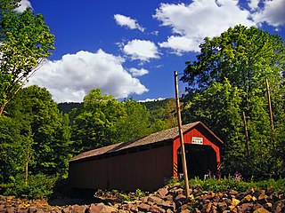
The Forksville Covered Bridge is a Burr arch truss covered bridge over Loyalsock Creek in the borough of Forksville, Sullivan County, in the U.S. state of Pennsylvania. It was built in 1850 and is 152 feet 11 inches (46.61 m) in length. The bridge was placed on the National Register of Historic Places in 1980. The Forksville bridge is named for the borough it is in, which in turn is named for its location at the confluence or "forks" of the Little Loyalsock and Loyalsock Creeks.

The Point Douglas–St. Louis River Road Bridge, built in 1865, is the second oldest known stone arch bridge in the state of Minnesota after Sibley's Ferry Bridge in Mendota, which was built in 1864. It was constructed in Stillwater Township to carry the Point Douglas to Superior Military Road over Brown's Creek. The bridge was listed on the National Register of Historic Places in 1975 for having local significance in the themes of engineering and transportation. It was nominated as an example of stone engineering and as a remnant of Minnesota's early government roads.

The Pithole Stone Arch Bridge is a 37-foot (11 m) masonry, deck arch bridge that spans Pithole Creek between Cornplanter and President Townships, Venango County in the U.S. state of Pennsylvania. The bridge was listed on the National Register of Historic Places in 1988 and was documented by the Historic American Engineering Record (HAER) in 1997.

The Warrington Stone Bridge is a historic stone arch bridge carrying Brugler Road over the Paulins Kill in the Warrington section of Knowlton Township in Warren County, New Jersey, United States. The bridge was built c. 1860 and added to the National Register of Historic Places on December 16, 1977, for its significance in transportation.
The Turner County Highway Department and/or its Turner County Highway Superintendent, in Turner County, South Dakota, arranged for the construction of numerous public works.

The Stone Arch Underpass is a historic stone arch bridge spanning Glen Road in Lebanon, New Hampshire. Built about 1848, it carried the Boston and Maine Railroad's former Northern Line. It is one of a small number of 19th-century stone arch bridges in the state, and the only one known in central western New Hampshire. The bridge was listed on the National Register of Historic Places in 1985. The railroad right-of-way has been functionally abandoned, and the bridge may become part of a continuation of the Northern Rail Trail.

The St. Alban's Bay Culvert is a historic bridge in Garrison Township, Minnesota, United States. It carries the four-lane U.S. Route 169 (US 169) over the head of a stream flowing out of Mille Lacs Lake. It was built from 1938 to 1939 as part of a major New Deal project to create a scenic parkway along the lakeshore. The bridge was listed on the National Register of Historic Places in 2015 as the St. Alban's Bay Culvert at Mille Lacs Lake for having state-level significance in the themes of architecture and politics/government. It was nominated for being a well-preserved example of the Minnesota Highway Department's earliest scenic improvements, its rare status as a highway bridge built by the department's Roadside Development Division—a unit usually focused on overlooks and waysides—and for its fine National Park Service rustic design.

The Bridge No. 63-137-90 is a historic bridge near Parker in rural Turner County, South Dakota. It was built sometime between 1934 and 1936, and is one of a large number of surviving stone bridges built as part of federal jobs programs in the county. It was listed on the National Register of Historic Places in 1999 as Bridge No. 63-137-090-Parker.
The Childstown Township Bridge Number S-15 is a historic bridge over an unnamed stream on 282nd Street in rural Turner County, South Dakota, west of Hurley. Built in 1940, it is one of a modest number of bridges surviving in the county that was built with New Deal funding. It was listed on the National Register of Historic Places in 2000.
The Dalton Township Bridge is a historic bridge over an unnamed stream on 446th Avenue in rural Turner County, South Dakota, north of Marion. Built in 1936, it is one of a modest number of bridges surviving in the county that was built with New Deal funding. It was listed on the National Register of Historic Places in 2000.
The Daneville Township Bridge No. E-26 is a historic stone arch bridge over an unnamed stream on 457th Avenue in rural Turner County, South Dakota, south of Viborg. Built in 1935, it is one of a modest number of bridges surviving in the county that was built with New Deal funding. It was listed on the National Register of Historic Places in 1999.
The Germantown Township Bridge S-29 is a historic stone arch bridge over an unnamed stream on 278th Street in rural Turner County, South Dakota, southwest of Chancellor. Built in 1942, it is one of a modest number of bridges surviving in the county that was built with New Deal funding. It was listed on the National Register of Historic Places in 2000.
The Salem Township Bridge E-1 is a historic stone arch bridge over an unnamed stream on 446th Street in rural Turner County, South Dakota, west of Hurley. Built in 1940, it is one of a modest number of bridges surviving in the county that was built with New Deal funding. It was listed on the National Register of Historic Places in 2000.
South Dakota Department of Transportation Bridge No. 63-016-150 is a historic bridge in rural western Turner County, South Dakota. Built in 1935, it is a well-preserved period stone-arch bridge, built with funding from a New Deal jobs program. It was listed on the National Register of Historic Places in 1999.

South Dakota Department of Transportation Bridge No. 63-132-040 is a historic bridge in rural Turner County, South Dakota. Built in 1939, it is a well-preserved period stone-arch bridge, built with funding from a New Deal jobs program. It was listed on the National Register of Historic Places in 1999.

The South Dakota Department of Transportation Bridge No. 63-160-056 was a historic truss bridge in rural Turner County, South Dakota, carrying 476th Avenue across the East Fork Vermillion River northeast of Parker. Built in 1905, it was one two surviving bridges built in the county by the J.A. Crane Company of Centerville, South Dakota. It was listed on the National Register of Historic Places in 1999. It was replaced by a modern steel beam bridge in about 2007.

South Dakota Department of Transportation Bridge No. 63-210-282 was a historic bridge in rural Turner County, South Dakota, carrying 461st Avenue across the East Fork Vermillion River southwest of Centerville. Built in 1909, it was a well-preserved example of bridges built for the county by the Iowa Bridge Company. It was listed on the National Register of Historic Places in 1999. The bridge's original Pratt through main span was replaced by a steel girder span in 2009–10.
Spring Valley Township Bridge No. E-31 is a historic bridge in rural Turner County, South Dakota, carrying 447th Avenue across unnamed stream west of Viborg. Built in 1938, it was a well-preserved example of a stone bridge built for the county with funding from the Works Progress Administration. It was listed on the National Register of Historic Places in 1999.

