Cheops Pyramid

Last updated
Cheops Pyramid
Cheops Pyramid seen from Yavapai Point.jpg
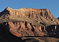
South aspect, from South Rim's Yavapai Point
Highest point
Elevation 5,401 ft (1,646 m) [1]
Prominence 800 ft (240 m) [1]
Parent peak Isis Temple (7,006 ft) [2]
Isolation 1.72 mi (2.77 km) [2]
Coordinates 36°07′13″N112°07′12″W / 36.1203033°N 112.1201072°W / 36.1203033; -112.1201072 Coordinates: 36°07′13″N112°07′12″W / 36.1203033°N 112.1201072°W / 36.1203033; -112.1201072 [3]
Geography
USA Arizona relief location map.svg
Red triangle with thick white border.svg
Cheops Pyramid
Location in Arizona
Usa edcp relief location map.png
Red triangle with thick white border.svg
Cheops Pyramid
Cheops Pyramid (the United States)
Location Grand Canyon National Park
Coconino County, Arizona, US
Parent range Kaibab Plateau [1]
Colorado Plateau
Topo map USGS Phantom Ranch
Geology
Type of rock sandstone, limestone, shale
Climbing
Easiest route class 4 climbing [2]

Cheops Pyramid is a 5,401-foot-elevation (1,646-meter) summit located in the Grand Canyon, in Coconino County of Arizona, US. [3] This butte is situated four miles north of Grand Canyon Village, 2.5 miles south-southwest of Buddha Temple, and 1.7 mile south-southeast of Isis Temple, which is the nearest higher neighbor. Topographic relief is significant as it rises 3,000 feet (910 meters) above the Colorado River in 1.5 mile. It was named by George Wharton James for the fanciful resemblance to the famous pyramid constructed by Egyptian Pharaoh Cheops. [4] This was in keeping with Clarence Dutton's tradition of naming geographical features in the Grand Canyon after mythological deities. [5] This butte's name was officially adopted in 1906 by the U.S. Board on Geographic Names. [3] According to the Köppen climate classification system, Cheops Pyramid is located in a Cold semi-arid climate zone. [6]

Contents

Geology

Cheops Pyramid is a flat-topped erosional remnant composed of Mississippian Redwall Limestone, overlaying the green shale slopes of the Cambrian Tonto Group, and below that red shale and Shinumo Quartzite of the Proterozoic Unkar Group. [7] Precipitation runoff from Cheops Pyramid drains south to the Colorado River via Phantom Creek (east), and Ninetyone Mile Creek (west).

See also

Related Research Articles

<span class="mw-page-title-main">Tonto Group</span> Cambrian geologic unit in the Grand Canyon region, Arizona

The Tonto Group is a name for an assemblage of related sedimentary strata, collectively known by geologists as a Group, that comprises the basal sequence Paleozoic strata exposed in the sides of the Grand Canyon. As currently defined, the Tonto groups consists of the Sixtymile Formation, Tapeats Sandstone, Bright Angel Shale, Muav Limestone, and Frenchman Mountain Dolostone. Historically, it included only the Tapeats Sandstone, Bright Angel Shale, and Muav Limestone. Because these units are defined by lithology and three of them interfinger and intergrade laterally, they lack the simple layer cake geology as they are typically portrayed as having and geological mapping of them is complicated.

<span class="mw-page-title-main">Temple Butte</span> Landform in the Grand Canyon, Arizona

Temple Butte, in the Grand Canyon, Arizona, US is a prominence below the East Rim. The butte lies on the west bank of the south-flowing Colorado River. The outfall from the Little Colorado River, draining from the Painted Desert to the east and southeast, is about 2-mi upstream.

<span class="mw-page-title-main">Isis Temple</span> Landform in the Grand Canyon, Arizona

Isis Temple is a prominence in the Grand Canyon, Arizona, Southwestern United States. It is located below the North Rim and adjacent to the Granite Gorge along the Colorado River. The Trinity Creek and canyon flow due south at its west border; its north, and northeast border/flank is formed by Phantom Creek and canyon, a west tributary of Bright Angel Creek; the creeks intersect about 3 mi (4.8 km) southeast, and 1.0 mi (1.6 km) north of Granite Gorge. The Isis Temple prominence, is only about 202 ft (62 m) lower than Grand Canyon Village, the main public center on Grand Canyon’s South Rim.

<span class="mw-page-title-main">Grand Canyon Supergroup</span> Sequence of sedimentary strata

The Grand Canyon Supergroup is a Mesoproterozoic to a Neoproterozoic sequence of sedimentary strata, partially exposed in the eastern Grand Canyon of Arizona. This group comprises the Unkar Group, Nankoweap Formation, Chuar Group and the Sixtymile Formation, which overlie Vishnu Basement Rocks. Several notable landmarks of the Grand Canyon, such as the Isis Temple and Cheops Pyramid, and the Apollo Temple, are surface manifestations of the Grand Canyon Supergroup.

<span class="mw-page-title-main">Hakatai Shale</span> Mesoproterozoic rock formation

The Hakatai Shale is a Mesoproterozoic rock formation with important exposures in the Grand Canyon, Coconino County, Arizona. It consists of colorful strata that exhibit colors varying from purple to red to brilliant orange. These colors are the result of the oxidation of iron-bearing minerals in the Hakatai Shale. It consists of lower and middle members that consist of bright-red, slope-forming, highly fractured, argillaceous mudstones and shale and an upper member composed of purple and red, cliff-forming, medium-grained sandstone. Its thickness, which apparently increases eastwards, varies from 137 to 300 m. In general, the Hakatai Shale and associated strata of the Unkar Group rocks dip northeast (10–30°) toward normal faults that dip 60° or more toward the southwest. This can be seen at the Palisades fault in the eastern part of the main Unkar Group outcrop area. In addition, thick, prominent, and dark-colored basaltic sills and dikes cut across the purple to red to brilliant orange strata of the Hakatai Shale.

<span class="mw-page-title-main">Zoroaster Temple</span> Landform in Coconino County, Arizona

Zoroaster Temple is a 7,123-foot-elevation (2,171-meter) summit located in the Grand Canyon, in Coconino County of Arizona, USA. It is situated 5.5 miles (8.9 km) northeast of the Yavapai Point overlook on the canyon's South Rim, from which it can be seen towering over 4,600 feet above the Colorado River and Granite Gorge. Its nearest higher neighbor is Brahma Temple, less than one mile to the north-northeast. Zoroaster Temple is named for Zoroaster, an ancient Iranian prophet. This name was used by George Wharton James and Clarence Dutton. Dutton began the tradition of naming geographical features in the Grand Canyon after mythological deities. This geographical feature's name was officially adopted in 1906 by the U.S. Board on Geographic Names.

<span class="mw-page-title-main">Brahma Temple (Grand Canyon)</span> Landform in the Grand Canyon, Arizona

Brahma Temple is a 7,551-foot-elevation summit located in the Grand Canyon, in Coconino County of Arizona, US. It is situated six miles (9.7 km) north-northeast of the Yavapai Point overlook on the canyon's South Rim, and 4.5 miles south of the North Rim's Bright Angel Point. It towers 5,000 feet above Phantom Ranch in Bright Angel Canyon. Its nearest higher neighbor is Oza Butte, four miles to the north-northwest. Other neighbors include Zoroaster Temple one mile to the south, and Deva Temple, 1.5 miles to the north. Brahma Temple is named for Brahma, the Hindu creator of the universe. This name was applied by Clarence Dutton who began the tradition of naming geographical features in the Grand Canyon after mythological deities. This geographical feature's name was officially adopted in 1906 by the U.S. Board on Geographic Names.

<span class="mw-page-title-main">Vishnu Temple (Grand Canyon)</span> Landform in the Grand Canyon, Arizona

Vishnu Temple is a 7,533-foot-elevation (2,296-meter) summit located in the Grand Canyon, in Coconino County of Arizona, US.

<span class="mw-page-title-main">Wotans Throne</span> Landform in the Grand Canyon, Arizona

Wotans Throne is a 7,721-foot-elevation (2,353-meter) summit located in the Grand Canyon, in Coconino County of Arizona, US. It is situated one mile immediately southwest of the Cape Royal overlook on the canyon's North Rim, 1.7 mile west-southwest of Freya Castle, two miles west-northwest of Vishnu Temple, and five miles east of Zoroaster Temple. It rises 5,200 feet above the Colorado River.

<span class="mw-page-title-main">Tower of Set</span> Landform in the Grand Canyon, Arizona

Tower of Set is a 6,012-foot-elevation (1,832-meter) summit located in the Grand Canyon, in Coconino County of Arizona, US. This butte is situated four miles north of Hopi Point overlook on the canyon's South Rim, two miles southeast of Tower of Ra, and three miles south-southwest of Shiva Temple, where it towers 3,600 feet above the Colorado River. Tower of Set was originally named Temple of Sett in 1879 by Thomas Moran, for the Egyptian deity of war, Set, because a niche worn into its wall evoked temples in the valley of the Nile. Another source states it was named by George Wharton James, in keeping with Clarence Dutton's tradition of naming geographical features in the Grand Canyon after mythological deities. This mountain's name was officially adopted in 1906 by the U.S. Board on Geographic Names. In 1919, Harriet Williams Russell Strong proposed connecting Hopi Point and Tower of Set across the river via an aerial tramway, an idea that never came to fruition. The first ascent was made in November 1977 by Bruce Grubbs and Jim Haggart. According to the Köppen climate classification system, Tower of Set is located in a cold semi-arid climate zone.

<span class="mw-page-title-main">Angels Gate</span> Landform in the Grand Canyon, Arizona

Angels Gate is a 6,761-foot (2,061 m)-elevation summit located in the Grand Canyon, in Coconino County of Arizona, United States. It is situated seven miles (11 km) due north of the Grandview Point overlook on the canyon's South Rim, three miles (4.8 km) west of Vishnu Temple, and three point five miles (5.6 km) southeast of Zoroaster Temple. Topographic relief is significant as it rises over 4,200 feet (1,300 m) above the Colorado River in three miles. Angels Gate is the place in Paiute mythology where the gods would return to earth by descending from the shadow world above. George Wharton James applied the "Angel Gate" name to this geographical feature in his book, In & Around the Grand Canyon, in 1900. This feature's name was officially adopted in 1906 by the U.S. Board on Geographic Names. Angels Gate has four peaks composed of Coconino Sandstone. The main highest summit and three spires are known as "Snoopy and his Doghouse" for a resemblance to Snoopy, and the first ascent was made April 1972 by Chuck Graf and Dave Ganci. According to the Köppen climate classification system, Angels Gate is located in a cold semi-arid climate zone.

<span class="mw-page-title-main">Buddha Temple (Grand Canyon)</span> Landform in the Grand Canyon, Arizona

Buddha Temple is a 7,212-foot-elevation (2,198-meter) summit located in the Grand Canyon, in Coconino County of northern Arizona, in the Southwestern United States. It is situated 6.5 miles (10.5 km) due north of the Mather Point overlook on the canyon's South Rim, and four miles southwest of the North Rim's Bright Angel Point. Topographic relief is significant as it rises over 3,800 feet in two miles above Bright Angel Canyon to the east, and 3,000 feet in less than one mile above Haunted Canyon to the immediate west. Its neighbors include Manu Temple 1.5 miles (2.4 km) to the northeast, Isis Temple 2.3 miles to the southwest, Zoroaster Temple 3.8 miles to the southeast, and Deva Temple, 3.5 miles to the east. Buddha Temple was named by Henry Gannett, a geographer for Clarence Dutton, in following Dutton's practice of naming features in the Grand Canyon after mythological deities, in this case Buddha. This geographical feature's name was officially adopted in 1906 by the U.S. Board on Geographic Names. The first ascent of this butte was made in 1973 by Bruce Grubbs, Chauncey Parker, and Mark Brown via the Northwest Arete. According to the Köppen climate classification system, Buddha Temple is located in a Cold semi-arid climate zone.

<span class="mw-page-title-main">Deva Temple</span> Landform in the Grand Canyon, Arizona

Deva Temple is a 7,353-foot-elevation (2,241-meter) summit located in the Grand Canyon, in Coconino County of northern Arizona, USA. It is situated three miles south of the North Rim's Bright Angel Point, and towers 3,700 feet above Bright Angel Canyon. Its nearest higher neighbor is Brahma Temple, 1.5 mile to the south. Other neighbors include Zoroaster Temple 2.5 miles to the south-southwest, Manu Temple three miles to the west-northwest, and Buddha Temple, 3.5 miles to the west. Deva Temple was named by Henry Gannett, a geographer for Clarence Dutton, in following Dutton's practice of naming features in the Grand Canyon after mythological deities, in this case, Deva. This geographical feature's name was officially adopted in 1906 by the U.S. Board on Geographic Names. According to the Köppen climate classification system, Deva Temple is located in a Cold semi-arid climate zone.

<span class="mw-page-title-main">Dox Castle</span> Landform in the Grand Canyon, Arizona

Dox Castle is a 4,780-foot-elevation (1,460-meter) summit located in the Grand Canyon, in Coconino County of northern Arizona, US. It is situated four miles north-northeast of Havasupai Point, two miles northwest of Evans Butte, and 2.5 miles southwest of Holy Grail Temple, where it towers 2,500 feet above the Colorado River.

<span class="mw-page-title-main">Gunther Castle</span> Landform in the Grand Canyon, Arizona

Gunther Castle is a 7,199-foot-elevation (2,194-meter) summit located in the Grand Canyon, in Coconino County of northern Arizona, US. It is situated three miles northwest of Chuar Butte, between Kwagunt Valley to the north, and Chuar Valley to the south. Topographic relief is significant as it rises nearly 4,500 feet above the Colorado River in three miles.

<span class="mw-page-title-main">Freya Castle</span> Landform in the Grand Canyon, Arizona

Freya Castle is a 7,288-foot-elevation (2,221-meter) summit located in the Grand Canyon, in Coconino County of northern Arizona, US. It is situated one mile southeast of the Cape Royal overlook on the canyon's North Rim, 1.5 mile north of Vishnu Temple, and 1.7 mile northeast of Wotans Throne. Topographic relief is significant as it rises 3,400 feet above the Unkar Valley in one mile.

<span class="mw-page-title-main">Newberry Butte</span> Landform in the Grand Canyon, Arizona

Newberry Butte is a 5,105-foot-elevation (1,556-meter) summit located in the Grand Canyon, in Coconino County of northern Arizona, US. It is situated 4.5 miles north of the South Rim's Grandview Point, three miles southwest of Vishnu Temple, and 2.5 miles south of Wotans Throne. Topographic relief is significant as it rises over 2,500 feet above the Colorado River and Granite Gorge in one mile. According to the Köppen climate classification system, Newberry Butte is located in a Cold semi-arid climate zone.

<span class="mw-page-title-main">Solomon Temple (Grand Canyon)</span> Landform in the Grand Canyon, Arizona

Solomon Temple is a 5,121-foot-elevation (1,561-meter) summit located in the Grand Canyon, in Coconino County of northern Arizona, USA. It is situated four miles north of Moran Point, 3.5 miles east of Newberry Butte, and 1.5 mile southeast of Rama Shrine, its nearest higher neighbor. Topographic relief is significant as it rises 2,500 feet above the Colorado River in less than one mile.

<span class="mw-page-title-main">Manu Temple</span> Landform in the Grand Canyon, Arizona

Manu Temple is a 7,184-foot-elevation (2,190-meter) summit located in the Grand Canyon, in Coconino County of northern Arizona, United States. It is situated one mile south of the North Rim's Widforss Point, 1.5 miles (2.4 km) northeast of parent Buddha Temple, and three miles southwest of the North Rim's Bright Angel Point. Topographic relief is significant as it rises nearly 3,600 feet in two miles above Bright Angel Canyon to the east, and 2,200 feet in less than one mile above Haunted Canyon to the immediate west. Its neighbors include Brahma Temple and Deva Temple to the east on the opposite side of Bright Angel Canyon. From the South Rim of the canyon it may be difficult to discern Manu Temple from the walls of the Kaibab Plateau one mile behind it, but when the lighting and atmosphere are favorable, this butte of great proportions can be seen clearly defined.

<span class="mw-page-title-main">Mather Point</span> Landform in the Grand Canyon, Arizona

Mather Point is a 7,119 foot (2,170 m)-cliff-elevation Point located in the central Grand Canyon, Coconino County of northern Arizona, United States. It was named in honor of Stephen Tyng Mather, an American industrialist and conservationist.

References

  1. 1 2 3 "Cheops Pyramid, Arizona". Peakbagger.com. Retrieved 2021-01-16.
  2. 1 2 3 "Cheops Pyramid – 5,401' AZ". Lists of John. Retrieved 2021-01-16.
  3. 1 2 3 "Cheops Pyramid". Geographic Names Information System . United States Geological Survey, United States Department of the Interior . Retrieved 2021-01-16.
  4. Gregory McNamee, Grand Canyon Place Names, 1997, Mountaineers Publisher, ISBN   9780898865332, page 34.
  5. Randy Moore and Kara Felicia Witt, The Grand Canyon: An Encyclopedia of Geography, History, and Culture, 2018, ABC-CLIO Publisher, page 151.
  6. Peel, M. C.; Finlayson, B. L.; McMahon, T. A. (2007). "Updated world map of the Köppen−Geiger climate classification". Hydrol. Earth Syst. Sci. 11. ISSN   1027-5606.
  7. N.H. Darton, Story of the Grand Canyon of Arizona, 1917, pages 26, 37.