
Kleptocracy is a government whose corrupt leaders (kleptocrats) use political power to expropriate the wealth of the people and land they govern, typically by embezzling or misappropriating government funds at the expense of the wider population. Thievocracy means literally the rule by thievery and is a term used synonymously to kleptocracy. One feature of political-based socioeconomic thievery is that there is often no public announcement explaining or apologizing for misappropriations, nor any legal charges or punishment levied against the offenders.

Boone Pickens Stadium has been home to the Oklahoma State University Cowboys football team in rudimentary form since 1919, and as a complete stadium since 1920. Aligned in an east-west direction since 1920, the field is the oldest in the Big 12 Conference.

Manjeri is a major town and municipality in Malappuram district, Kerala, India. It is the fourth-most populous municipality in state. It is situated 23 kilometres (14 mi) southeast to Karipur International Airport and 13 kilometres (8.1 mi) northeast to Malappuram, the district headquarters, and forms a part of Malappuram metropolitan area. It is one of the major commercial towns under the Malappuram urban agglomeration and serves as the headquarters of Eranad Taluk. Manjeri Municipality is a Local Self Government Institution with a jurisdiction of three villages namely Manjeri, Payyanad, and Narukara.

The Now Arena is a multi-purpose arena in Hoffman Estates, Illinois, a northwest suburb 25 miles (40 km) from Chicago, near land which formerly contained the Poplar Creek Music Theater. Since 2016, the arena has been home to the Windy City Bulls, the Chicago Bulls' affiliate in the NBA G League.

Muthuthala is a small town, village and gram panchayat. It lies northwest of Pattambi in Palakkad district, of the state of Kerala, India. It is located on the banks of the Bharathapuzha River. The infrastructure of the panchayath is divided into Kodumunda and Muthuthala.Muthuthala, Kodumunda and Karakkuth are important centres. The adjacent villages to Muthuthala are Pallippuram, Koppam and Pattambi. The major institutions are GOHSS Pattambi, GHSS Kodumunda, GLPS Kodumunda AMLP Kodumunda, Aups muthuthala, Aups perumudiyoor, SBI muthuthala etc. Also there are temples such as sree muthassiyar kavu, ayappan kavu, Ganapthi temple muthuthala. Siva temple perumudiyoor, kozhikottii temple etc. The main Islamic symbol of this village is Muhyidheen Juma Masjid located at Muthuthala centre. An Islamic educational institution named as Thanveerul Islam Madrassa is also running near to this. Thes agnostoma somayagam is conducted at perumudiyoor on 2016. Lakhs of people visited there. Major cultivation is paddy here. Banana and rubber plantations are also abundant here.

An economy is an area of the production, distribution and trade, as well as consumption of goods and services. In general, it is defined as a social domain that emphasize the practices, discourses, and material expressions associated with the production, use, and management of scarce resources'. A given economy is a set of processes that involves its culture, values, education, technological evolution, history, social organization, political structure, legal systems, and natural resources as main factors. These factors give context, content, and set the conditions and parameters in which an economy functions. In other words, the economic domain is a social domain of interrelated human practices and transactions that does not stand alone.

Idimuzhikkal or Chelembra is a town in Malappuram district, Kerala, India. Chelembra is the Panchayath and Idimuzhikal is the capital of this Panchayath. Chelembra grama panchayat in the district.
Naduvannur is a Census town in Kozhikode district in the state of Kerala, India and a part of Kozhikode Urban Agglomeration. The name Naduvannur denotes that it was the centre of the territory of Kurumbranad. 'Nadu' means centre and ur(oor) means place.
Kurumbalangode is a small village located near Nilambur in Malappuram district of Kerala, India. It is situated in chungathara grama panchayath. It is situated river side of Chaliyar River and western ghats. 70% of the local people are directly or indirectly working with rubber products and rest of them are working abroad, Govt job and doing other professions. The main source of income of the people is from rubber or latex related industries. There is a Higher Secondary School called Nirmala Higher Secondary School and several primary schools such as, Government UP School Kurumbalangode, Nirmala English Medium School, AMLP School Mundapadam etc. The school has contributed immensely for the educational development of Kurumbalangode, Erumamunda and near by villages. Kurumbalangode is one of the highly developed village in chungathara panchayath and Nilambur municipality.

Pallikkal is a T-shaped town, village and gram panchayat in Kondotty Taluk, Malappuram district in the state of Kerala, India.

Parappur (Malayalam: പറപ്പൂര്) is a village and townland two kilometers north of Kottakkal in Malappuram district in the state of Kerala, India.

Peruvallur is a census town in Tirurangadi Taluk, Malappuram district in the state of Kerala, India. Peruvallur has many agricultural fields and about 35 pure water ponds.
Thennala is a Grama panchayat in Malappuram district in the Indian state of Kerala. Thennala is known for its cultured population and localities. National Highway (NH-17) passes through the pookkipparamb. Parapanangadi is the nearest railway station (12 km) and Calicut International airport is the nearest airport (23 km).
Vallapuzha is a village and gram panchayat in Pattambi Taluk, Palakkad district in the state of Kerala, India.
Vailathur is a town 4 km from Tirur on the way to Malappuram and it is a junction turning to Valancheri and Malappuram. It also has a road to Tanur in the west side. Vailathur is a ward of Tanur Block Panchayat.
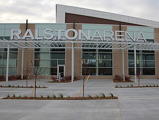
The Liberty First Credit Union Arena, formerly known as Ralston Arena and sometimes as Ralston Sports and Event Center, is an arena located in Ralston, Nebraska, a suburb of Omaha. It serves as the home of the Omaha Lancers of the United States Hockey League and the Omaha Beef of Champions Indoor Football. It was home to the Omaha Mavericks NCAA Division I men's basketball team, representing the University of Nebraska Omaha, from its opening until the end of the 2014–15 season. The school opened Baxter Arena for the 2015–16 season.

On 8 November 2016, the Government of India announced the demonetisation of all ₹500 and ₹1,000 banknotes of the Mahatma Gandhi Series. It also announced the issuance of new ₹500 and ₹2,000 banknotes in exchange for the demonetised banknotes. Prime Minister Narendra Modi claimed that the action would curtail the shadow economy, increase cashless transactions and reduce the use of illicit and counterfeit cash to fund illegal activity and terrorism.
AMLP School Cheruputhur also known as Aided Mapila Lower Primary School is a private aided lower primary school in Kerala, India. It has its own building. The school has total 8 classrooms. The lowest Class is 1 and the highest class in the school is 4. This school has 9 teachers. The school is currently being renovated by Mr. Mohammed Kamarrudin, a philanthropist from Dubai. He is an alumnus of the school and is fulfilling his childhood dream of making the school the best in the area. There is library facility available in this school.
Vengara Grama Panchayat is grama panchayat in Malappuram district, Kerala, India. It is situated in Vengara village in Thiroorangadi taluk. This panchayat was the largest panchayat in Malappuram district and was divided into Vengara and Kannamangalam in 1999-2000 year. The current geographical area of the panchayat is 18.66 km2. Though 70% of people in the panchyat depends upon agriculture, the income source is overseas jobs.

