
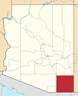
Cochise County is located in the southeastern corner of the U.S. state of Arizona. The population was 131,346 at the 2010 census. The county seat is Bisbee, while the most populous city is Sierra Vista.

The Chiricahua Mountains massif is a large mountain range in southeastern Arizona which is part of the Basin and Range province of the west and southwestern United States and northwest Mexico; the range is part of the Coronado National Forest. The highest point, Chiricahua Peak, rises 9,759 feet (2,975 m) above sea level, approximately 6,000 feet (1,800 m) above the surrounding valleys. The range takes its name from the Chiricahua Apaches native to the region.

Chiricahua National Monument is a unit of the National Park System located in the Chiricahua Mountains of southeastern Arizona. The monument was established on April 18, 1924, to protect its extensive hoodoos and balancing rocks. The Faraway Ranch, which was owned at one time by Swedish immigrants Neil and Emma Erickson, is also preserved within the monument.

This is a directory of properties and districts listed on the National Register of Historic Places in Arizona. There are about fourteen hundred listed sites in the state, and each of its fifteen counties has at least ten listings on the National Register. Forty-seven of the state's sites are further designated as National Historic Landmarks.
Fort Bowie was a 19th-century outpost of the United States Army located in southeastern Arizona near the present day town of Willcox, Arizona. The remaining buildings and site are now protected as Fort Bowie National Historic Site.

Chiricahua Peak is the name of a 9,763 feet (2,976 m) peak located in the Chiricahua Mountains of southeastern Arizona, located about 35 miles (56 km) north of the United States–Mexico border. It is the highest summit in the Chiricahua Mountains and the highest point in Cochise County.

Chiricahua National Forest was established as the Chiricahua Forest Reserve in Cochise County, Arizona by the General Land Office on July 1, 1902 with 169,600 acres (686 km2). After the transfer of federal forests to the U.S. Forest Service in 1905, it became a National Forest on March 4, 1907. On July 1, 1908 it absorbed Peloncillo National Forest, including lands in Hidalgo County, New Mexico. On July 1, 1917 Chiricahua was absorbed by Coronado National Forest and the name was discontinued.

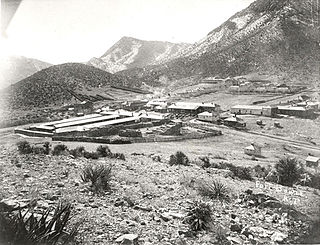
The Faraway Ranch Historic District is part of the Chiricahua National Monument in southern Arizona, and preserves an area associated with the final conflicts with the local Apache, one of the last frontier settlements, and in particular, its association with the people who promoted the establishment of the Chiricahua National Monument. Faraway Ranch is located in Bonita Canyon, which lies at an approximate altitude of 5160 feet and opens in a southwesterly direction into the Sulphur Springs Valley.
This is a list of the National Register of Historic Places listings in Cochise County, Arizona. It is intended to be a complete list of the properties and districts on the National Register of Historic Places in Cochise County, Arizona, United States. The locations of National Register properties and districts for which the latitude and longitude coordinates are included below, may be seen in a map.

Pearce, Arizona, and Sunsites, Arizona, are adjacent unincorporated communities in the Sulphur Springs Valley of Cochise County, Arizona, United States. The two communities are often referred to as Pearce-Sunsites, Pearce/Sunsites, or Pearce Sunsites.

The Portal Ranger Station, also known as Portal Work Station, is located in Cave Creek Canyon, in the eastern Chiricahua Mountains, in Coronado National Forest near Portal, southeastern Arizona.
Architects of the National Park Service are the architects and landscape architects who were employed by the National Park Service (NPS) starting in 1918 to design buildings, structures, roads, trails and other features in the United States National Parks. Many of their works are listed on the National Register of Historic Places, and a number have also been designated as National Historic Landmarks.

The Geologic history of the Chiricahua Mountains concerns the Chiricahua Mountains, an inactive volcanic range located in Coronado National Forest of southeastern Arizona, in the United States. They are part of an "archipelago" of mountain ranges known as the sky islands that connect the Sierra Madre Occidental in Mexico with the Rocky Mountains. The Chiricahua Mountains are home to a number of unusual geologic features associated with the Turkey Creek Caldera, some of which are protected by Chiricahua National Monument. The landscape has been dominantly shaped by faulting due to Basin and Range extension during the Miocene, volcanic activity, and erosion.

Ja Hu Stafford (1834–1913) was a pioneer of Cochise County, Arizona.
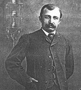
Neil Erickson was a Swedish-born American pioneer in Cochise County, Arizona. He and the members of his family were the founders and operators of Faraway Ranch now in the Faraway Ranch Historic District of the Chiricahua National Monument in the Chiricahua Mountains in southern Arizona.

Bonita Canyon is a box canyon on the western slope of the Chiricahua Mountains in southeastern Arizona, which lies at 5,360 feet (1,630 m) in elevation and opens in a southwesterly direction into the Sulphur Springs Valley.

