Cityscape of Cincinnati

Last updated
Downtown Cincinnati viewed from Mount Adams Downtown Cincinnati viewed from Mt. Adams.jpg
Downtown Cincinnati viewed from Mount Adams

Cincinnati, Ohio is home to numerous structures that are noteworthy due to their architectural characteristics or historic associations. The city also boasts Fountain Square and a riverfront that is being revitalized under The Banks project.

Contents

Famous buildings

Cincinnati Music Hall Cincinnati Music Hall (right-facing).jpg
Cincinnati Music Hall
The Carew Tower is the 2nd tallest building and a great example of Art Deco. Carew Tower Full.jpg
The Carew Tower is the 2nd tallest building and a great example of Art Deco.

Carew Tower: The second tallest building in Cincinnati and a National Historic Landmark with an open-air observation deck on 49th story. It was the basis for the Empire State Building and contains some of the finest examples of French Art Deco architecture.[ citation needed ]

Great American Tower at Queen City Square: The tower replaced the Carew Tower as Cincinnati's tallest.

Ingalls Building: The world's first reinforced concrete skyscraper.

Fourth and Vine Tower: The 5th tallest in the world and tallest in the U.S., outside of New York City when it was built in 1914.

Scripps Center: Home of the world headquarters for the E. W. Scripps Company.

Star Tower: A free-standing TV/Radio transmission tower.

Aronoff Center: Performing arts center, by world-renowned architect César Pelli.

Cincinnati Union Terminal: A train station (still housing an Amtrak station) that is now primarily a museum and widely considered one of the finest examples of the Art Deco style.

Cincinnati Music Hall: One of the oldest and largest performance halls in the U.S. particularly noted for its Gothic German architecture.

National Underground Railroad Freedom Center was recently built along the bank of the Ohio River as part of The Banks Project.

The John A. Roebling Suspension Bridge with Cincinnati in the background 2008-10-05 02 The John Roebling Bridge adj.jpg
The John A. Roebling Suspension Bridge with Cincinnati in the background

Riverbend Music Center is a 20,000-seat outdoor amphitheater complex located on the banks of the Ohio River at the eastern edge of the city limits. It features two covered pavilions each seating approximately 4,500 people and was designed by renowned architect Michael Graves, an alumnus of the University of Cincinnati.

Rosenthal Center for Contemporary Art by Iraqi architect Zaha Hadid, 2004 winner of the Pritzker Architecture Prize. Called by the New York Times the "most important American building to be completed since the end of the Cold War."

Saint Peter in Chains Basilica is the main Roman Catholic Basilica for the Greater Cincinnati region. Its cornerstone was set on May 20, 1841—and upon completion, it became the tallest structure in Cincinnati for its time.

Isaac M. Wise Temple is the historic temple erected for Rabbi Isaac Mayer Wise who was the founder of American Reform Judaism.

The Union Central Insurance Company building in Forest Park, a suburb of Cincinnati OH. Built 1964

Fountain Square

Tyler Davidson Fountain, centerpiece of Fountain Square TylerDavidsonFountainAtNight.jpg
Tyler Davidson Fountain, centerpiece of Fountain Square

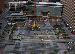
Fountain Square is a public square in Downtown Cincinnati, located at Fifth Street and Vine. Its centerpiece is the landmark bronze Tyler Davidson Fountain. The square is a popular hardscape, surrounded by hotels, banks, department stores, and restaurants. The space was donated to the city of Cincinnati by prominent citizen Henry Probasco and dedicated on its completion in 1871 to his brother-in-law, Tyler Davidson.

In 1998, the fountain underwent extensive restoration. In September 2005, the fountain was temporarily moved to the Cincinnati Art Museum while Square was extensively renovated. The fountain was returned to a different location on the Square on August 19, 2006, in preparation for its re-opening in early October 2006.

Fountain Square was featured in the credits of the television series WKRP in Cincinnati .

Riverfront

Cincinnati's riverfront skyline Cincinnati Skyline Dusk.JPG
Cincinnati's riverfront skyline

Being situated on the Ohio River, Cincinnati is home to several prominent bridges that connect the downtown to Covington, Kentucky and Newport, Kentucky. In fact, there are more bridges that cross the Ohio River in Cincinnati than at any other place on the River. These bridges include the historic and picturesque John A. Roebling Suspension Bridge, which served as a prototype for the Brooklyn Bridge; the Daniel Carter Beard Bridge (aka The Big Mac Bridge); and the Newport Southbank Bridge (sometimes referred to as the Purple People Bridge), which is the longest pedestrian-only bridge in the United States connecting two states.

Cincinnatians place great value on the riverfront for its entertainment and economic benefits. The riverfront is home to both Paycor Stadium home of the Cincinnati Bengals, and to Great American Ball Park home of the Cincinnati Reds, as well as to the National Underground Railroad Freedom Center. "The Banks", a 40-acre (160,000 m2) site planned for future mixed commercial, residential, and public recreational use is also on the riverfront. The annual WEBN Fireworks on Labor Day are celebrated at the river, as is Tall Stacks, the largest gathering of steam riverboats in the nation. Many cultural festivals are held at Sawyer Point, including the Cincy Blues Fest and the Cincinnati Celtic Festival, formerly held at Ault Park. Coney Island is on the river several miles east (upriver) from the Downtown area.

Neighborhoods

Over-the-Rhine Over-The-Rhine.JPG
Over-the-Rhine

Cincinnati's unique geography nestles its neighborhoods in small basins and the hillsides that overlook them. Because of this, many of the city's neighborhoods developed very strong identities. Today's city neighborhoods such as Clifton, Hyde Park, Mount Washington, Westwood, College Hill, and Carthage were originally settled as separate villages, with business sections of their own. Over-the-Rhine was an important neighborhood in German American history. Northside also has its own identity.

Also highly important to the city's landscape is the division into "East Side and West Side." The division came about after the construction of Interstate Route 71, which runs north from Kentucky towards Columbus, Ohio. The rivalry has been intense at times (limited violence or reported discrimination), but is considered mostly light-hearted, although a good number of city residents take the division more seriously. Accents, fashion, attitudes, city planning (i.e., the way the houses are laid out), financial demographics, and other items are some of the stereotypes and behaviors that separate the two distinctions. Though this division is often considered a point of contention in the city, it has only led to limited incidents of violence or litigious discrimination and is considered more of a "charming quirk" than a divisive hindrance to society.

Larger divisions

Interstates 71 and 75 define the four major areas of the city.

The suburbs of the city also tend to follow this pattern, with higher density found between the two highways (the business centers of Blue Ash, Evendale, and Sharonville, for instance), heavy industry and freight located along Mill Creek and I-75 (The sprawling GE Aviation plant, for instance), and residential suburbs to the east and west. In Kentucky the pattern continues, with densely populated Covington and Newport located between the 71/75 and 471 interstates, and lower density residential cities such as Villa Hills and Fort Thomas to either side.

New development projects

Fountain Square was renovated by 3CDC in 2005 FountainSquare.jpg
Fountain Square was renovated by 3CDC in 2005

Much of the new development plans are run through the Cincinnati Center City Development Corporation (3CDC) which was formed in July 2003 as part of the overall system to increase the effectiveness and efficiency of development activities in the City, as recommended by The Cincinnati Economic Development Task Force. 3CDC works collaboratively with the City and the Port of Greater Cincinnati Development Authority to take full advantage of each organization's resources and abilities. They plan to develop in three specific areas: The Banks, Fountain Square, Over-The-Rhine

Cincinnati's City Manager Office also organizes and promotes development within the city, through the Economic Development Division. EDD serves as a liaison between the City and developers, development authorities, and development corporations that are seeking to promote development within the City. These are broken down into Commercial, Mixed-Use, and Residential.

See also

Related Research Articles

<span class="mw-page-title-main">Downtown Pittsburgh</span> Neighborhood of Pittsburgh in Allegheny County, Pennsylvania, United States

Downtown Pittsburgh, colloquially referred to as the Golden Triangle, and officially the Central Business District, is the urban downtown center of Pittsburgh, Pennsylvania, United States. It is located at the confluence of the Allegheny River and the Monongahela River whose joining forms the Ohio River. The triangle is bounded by the two rivers.

<span class="mw-page-title-main">Over-the-Rhine</span> United States historic place

Over-the-Rhine is a neighborhood in Cincinnati, Ohio, United States. Historically, Over-the-Rhine has been a working-class neighborhood. It is among the largest, most intact urban historic districts in the United States.

<span class="mw-page-title-main">Downtown Louisville</span>

Downtown Louisville is the largest central business district in the Commonwealth of Kentucky and the urban hub of the Louisville, Kentucky Metropolitan Area. Its boundaries are the Ohio River to the north, Hancock Street to the east, York and Jacob Streets to the south, and 9th Street to the west. As of 2015, the population of Downtown Louisville was 4,700, although this does not include directly surrounding areas such as Old Louisville, Butchertown, NuLu, and Phoenix Hill.

<span class="mw-page-title-main">Downtown Portland, Oregon</span> Neighborhood in Portland, Oregon, United States

Downtown Portland is the central business district of Portland, Oregon, United States. It is on the west bank of the Willamette River in the northeastern corner of the southwest section of the city and where most of the city's high-rise buildings are found.

<span class="mw-page-title-main">Downtown Jacksonville</span> Neighborhood of Jacksonville, Florida

Downtown Jacksonville is the historic core and central business district (CBD) of Jacksonville, Florida. It comprises the earliest area of the city to be developed and is located in its geographic center along the narrowing point of the St. Johns River.

<span class="mw-page-title-main">Downtown Spokane</span> Central business district of Spokane in Washington, United States

Downtown Spokane or Riverside is the central business district of Spokane, Washington. The Riverside neighborhood is roughly bounded by I-90 to the south, Division Street to the east, Monroe Street to the west and Boone Avenue to the north. The topography of Downtown Spokane is mostly flat except for areas downstream of the Spokane Falls which are located in a canyon; the elevation is approximately 1,900 feet (580 m) above sea level.

<span class="mw-page-title-main">Downtown Columbus, Ohio</span> Neighborhood in Columbus, Ohio

Downtown Columbus is the central business district of Columbus, Ohio. Downtown is centered on the intersection of Broad and High Streets, and encompasses all of the area inside the Inner Belt. Downtown is home to most of the tallest buildings in Columbus.

<span class="mw-page-title-main">Hyde Park, Cincinnati</span> Neighborhood of Cincinnati in Ohio, United States

Hyde Park is a neighborhood on the east side of Cincinnati, Ohio. The population was 14,193 at the 2020 census.

Columbus, the state capital and Ohio's largest city, has numerous neighborhoods within its city limits. Neighborhood names and boundaries are not officially defined. They may vary or change from time to time due to demographic and economic variables.

<span class="mw-page-title-main">The Banks, Cincinnati</span> Mixed-use commercial, entertainment, retail, office in Ohio, United States

The Banks is a mixed-use development and neighborhood along the Ohio River in Cincinnati, Ohio, on the land between Paycor Stadium and Great American Ball Park.

<span class="mw-page-title-main">Detroit International Riverfront</span> Area of Detroit, Michigan that borders the Detroit River

The Detroit International Riverfront is a tourist attraction and landmark of Detroit, Michigan, extending from the Ambassador Bridge in the west to Belle Isle in the east, for a total of 5.5 miles. The International Riverfront encompasses a cruise ship passenger terminal and dock, a marina, a multitude of parks, restaurants, retail shops, skyscrapers, and high rise residential areas along with Huntington Place. The Marriott at the Renaissance Center and the Robert's Riverwalk Hotel are also situated along the International Riverfront. Private companies and foundations together with the city, state, and federal government have contributed several hundred million dollars toward the riverfront development. Key public spaces in the International Riverfront, such as the RiverWalk, Dequindre Cut Greenway and Trail, William G. Milliken State Park and Harbor, and a cruise ship passenger terminal and dock at Hart Plaza complement the architecture of the area. The area provides a venue for a variety of annual events and festivals including the Detroit Electronic Music Festival, Detroit Free Press International Marathon, the Detroit International Jazz Festival, Motor City Pride, the North American International Auto Show, River Days and Detroit China Festival. In February 2021, the Detroit International Riverfront was voted best riverwalk in the United States by USA Today readers. It was selected a second time as the best riverwalk in the U.S. in 2022.

<span class="mw-page-title-main">Cityscape of Louisville, Kentucky</span>

Louisville, Kentucky is home to numerous structures that are noteworthy due to their architectural characteristics or historic associations, the most noteworthy being the Old Louisville neighborhood, the third largest historic preservation district in the United States. The city also boasts the postmodern Humana Building and an expanding Waterfront Park which has served to remove the former industrial appearance of the riverfront.

<span class="mw-page-title-main">Downtown Omaha</span> Central business district in Omaha

Downtown Omaha is the central business, government and social core of the Omaha-Council Bluffs metropolitan area, U.S. state of Nebraska. The boundaries are Omaha's 20th Street on the west to the Missouri River on the east and the centerline of Leavenworth Street on the south to the centerline of Chicago Street on the north, also including the CHI Health Center Omaha. Downtown sits on the Missouri River, with commanding views from the tallest skyscrapers.

<span class="mw-page-title-main">Vine Street, Cincinnati</span>

Vine Street functions as Cincinnati's central thoroughfare. It bisects the downtown neighborhood, as well as the adjacent Over-the-Rhine neighborhood. The street also serves as the dividing line for the "east" and "west" sides of the city. All east-west addresses in the city start at zero at Vine Street.

<span class="mw-page-title-main">Cincinnati</span> City in Ohio, United States

Cincinnati is a city in and the county seat of Hamilton County, Ohio, United States. Settled in 1788, the city is located at the northern side of the confluence of the Licking and Ohio rivers, the latter of which marks the state line with Kentucky. The city is the economic and cultural hub of the Cincinnati metropolitan area. With an estimated population of 2,265,051, it is Ohio's largest metropolitan area and the nation's 30th-largest, and with a city proper population of 309,317, Cincinnati is the third-most populous city in Ohio after Columbus and Cleveland, and 65th in the United States.

<span class="mw-page-title-main">Downtown Cincinnati</span> Neighborhood in Cincinnati, Ohio, United States

Downtown Cincinnati is the central business district of Cincinnati, Ohio, United States, as well the economic and symbiotic center of the Cincinnati metropolitan area. It also contains a number of urban neighborhoods in the low land area between the Ohio River and the high land areas of uptown. These neighborhoods include Over-the-Rhine, Pendleton, Queensgate, and West End.

<span class="mw-page-title-main">Architecture of Albany, New York</span>

The architecture of Albany, New York, embraces a variety of architectural styles ranging from the early 18th century to the present. The city's roots date from the early 17th century and few buildings survive from that era or from the 18th and early 19th century. The completion of the Erie Canal in 1825 triggered a building boom, which continued until the Great Depression and the suburbanization of the area afterward. This accounts for much of the construction in the city's urban core along the Hudson River. Since then most construction has been largely residential, as the city spread out to its current boundaries, although there have been some large government building complexes in the modernist style, such as Empire State Plaza, which includes the Erastus Corning Tower, the tallest building in New York outside of New York City.

<span class="mw-page-title-main">Neighborhoods in Manchester, New Hampshire</span>

Manchester, the largest city in New Hampshire, is made up of 25 neighborhoods, according to the Manchester Planning Board in its 2010 master plan. Recognition of particular neighborhoods varies, with some having neighborhood associations, but none have any legal or political authority.

Cincinnati has several modes of transportation including sidewalks, roads, public transit, bicycle paths and regional and international airports. Most trips are made by car, with transit and bicycles having a relatively low share of total trips; in a region of just over 2 million people, less than 80,000 trips are made with transit on an average day. The city is sliced by three major interstate highways, I-71, I-74 and I-75, and circled by a beltway several miles out from the city limits. The region is served by two separate transit systems, one on each side of the river. SORTA, on the Ohio side is about 6 times larger than TANK on the Kentucky side. The transit system is largely radial with almost all lines terminating in or departing from Downtown Cincinnati. The city's hills preclude the regular street grid common to many cities built up in the 19th century, and outside of the downtown basin, regular street grids are rare except for in patches of flat land where they're small and oriented according to topography.

<span class="mw-page-title-main">Downtown Milwaukee</span> Area of Milwaukee, Wisconsin, United States

Downtown Milwaukee is the central business district of Milwaukee, Wisconsin. The economic and symbolic center of the city and the Milwaukee metropolitan area, it is Milwaukee's oldest district and home to many of region's cultural, financial educational and historical landmarks including Milwaukee City Hall, Fiserv Forum and the Milwaukee Art Museum. The city's modern history began in Downtown Milwaukee in 1795 when fur trader Jacques Vieau (1757–1852) built a post along a bluff on the east side, overlooking the Milwaukee and Menomonee rivers.

References

  1. "The Uptown Area". Uptown Consortium. 2010. Archived from the original on 16 August 2011. Retrieved 29 May 2011.