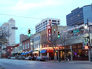
Sixth Street is a historic street and entertainment district in Austin, Texas, located within the city's urban core in downtown Austin. Sixth Street was formerly named Pecan Street under Austin's older naming convention, which had east–west streets named after trees and north–south streets named after Texas rivers.

Downtown Louisville is the largest central business district in the Commonwealth of Kentucky and the urban hub of the Louisville, Kentucky Metropolitan Area. Its boundaries are the Ohio River to the north, Hancock Street to the east, York and Jacob Streets to the south, and 9th Street to the west. As of 2015, the population of Downtown Louisville was 4,700, although this does not include directly surrounding areas such as Old Louisville, Butchertown, NuLu, and Phoenix Hill.

The White Building, also known as the Heberling Building, is located in the city of Bloomington, Illinois, United States. Located along Bloomington's East Douglas Street, the building was added to the National Register of Historic Places in June 1994 and represents one of the better examples of Commercial style architecture still extant in the city. It was built by Bloomington resident Samuel R. White in 1894–1895 to house his furniture sales company. By 1903 the Heberling Brothers pharmacy and their associated businesses occupied most of the building and the White company had moved its facilities to a nearby location. The White Building is a five-story red brick building which is elaborately windowed and has a three-story connected extension to its west which probably predates it.

The city of Davenport, Iowa, United States has neighborhoods dating back to the 1840s. The Davenport Plan and Zoning Commission divided the city into five areas: downtown, central, east end, near north, and northwest and west end. The neighborhoods contain many architectural designs, including Victorian, Queen Anne, and Tudor Revival. Many of the original neighborhoods were first inhabited by German settlers.

The Main Street Historic District in Medina, New York, United States, is the downtown commercial core of the village. It is a 12-acre (4.9 ha) area stretching south along Main Street from the Erie Canal to the railroad tracks.

South Downtown is a historic neighborhood of Downtown Atlanta, Georgia, United States. South Downtown is primarily home to city, county, state, and federal governmental offices, which prompted the city to adopt signage declaring the area "Government Walk." Although much of South Downtown is dominated by surface parking lots, the neighborhood was passed over during the redevelopment boom of the 1960s and 1970s that resulted in the demolition of much of Downtown's architecturally significant buildings. The result is myriad buildings from the 1950s and earlier that retain their historic structural integrity.
The Central Troy Historic District is an irregularly shaped, 96-acre (39 ha) area of downtown Troy, New York, United States. It has been described as "one of the most perfectly preserved 19th-century downtowns in the [country]" with nearly 700 properties in a variety of architectural styles from the early 19th to mid-20th centuries. These include most of Russell Sage College, one of two privately owned urban parks in New York, and two National Historic Landmarks. Visitors ranging from the Duke de la Rochefoucauld to Philip Johnson have praised aspects of it. Martin Scorsese used parts of downtown Troy as a stand-in for 19th-century Manhattan in The Age of Innocence.

The Crescent Warehouse Historic District is a 10.5-acre (4.2 ha) historic district in Downtown Davenport, Iowa, United States. The district is a collection of multi-story brick structures that formerly housed warehouses and factories. Most of the buildings have been converted into loft apartments. The district was listed on the National Register of Historic Places in 2003.

The Emory Place Historic District is a historic district in Knoxville, Tennessee, United States, located just north of the city's downtown area. The district consists of several commercial, residential, religious, and public buildings that developed around a late nineteenth century train and trolley station. The district includes the Knoxville High School building, St. John's Lutheran Church, First Christian Church, and some of the few surviving rowhouses in Knoxville. The district was listed on the National Register of Historic Places in 1994.

Gay Street is a street in Knoxville, Tennessee, United States, that traverses the heart of the city's downtown area. Since its development in the 1790s, Gay Street has served as the city's principal financial and commercial thoroughfare, and has played a primary role in the city's historical and cultural development. The street contains Knoxville's largest office buildings and oldest commercial structures. Several buildings on Gay Street have been listed on the National Register of Historic Places.

The Chelsea Commercial Historic District is a historic district located along both sides of Main Street from Orchard to North Street in Chelsea, Michigan; the district also includes the adjacent 100 blocks of Jackson, East Middle, and West Middle Streets, as well as structures on Park, East, and Orchard Streets. It was listed on the National Register of Historic Places in 2011.

Downtown Lafayette Historic District is a national historic district located at Lafayette, Tippecanoe County, Indiana. Lafayette began in 1825 as a transportation center for the west central area of Indiana. Its development and growth reflects the changes in transportation over the intervening years. From its location along the Wabash River, it grew first with river travel then for a short while from the Wabash and Erie Canal. When the railroads arrived in the 1850s, the town began to grow, initially along the rail lines. The Downtown Lafayette Historic District reflects these early changes.

The Petoskey Downtown Historic District is a commercial historic district, roughly bounded by Rose, Division, Michigan, and Petoskey streets in Petoskey, Michigan. It was listed on the National Register of Historic Places in 1986.

The Holland Downtown Historic District is a commercial historic district located along Eighth Street from just east of College Avenue to River Avenue, and along and River Avenue from Ninth Street to just north of Eighth Street in Holland, Michigan. The district was listed on the National Register of Historic Places in 1990.
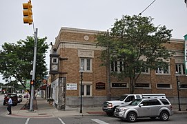
The Niles Downtown Historic District is a commercial historic district located in Niles, Michigan along Sycamore, Main and Cedar Streets between Front and 5th. The districts was listed on the National Register of Historic Places in 2007.

The Bay City Downtown Historic District is a primarily commercial historic district, located in Bay City, Michigan and roughly bounded by the Saginaw River, Second Street, Adam Street, and Center Avenue. It was listed on the National Register of Historic Places in 1985.

The 'Ionia Downtown Commercial Historic District is a primarily commercial district located roughly along West Main and Washington Streets, from Dexter Street to Library Street, in Ionia, Michigan. The district was listed on the National Register of Historic Places in 1984.

The Portland Downtown Historic District is a primarily commercial historic district located along Kent and Maple Streets, between Academy Street and the Looking Glass River, in Portland, Michigan. It was listed on the National Register of Historic Places in 2005.

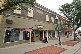
The Downtown Holly Commercial District is a commercial historic district located primarily South Saginaw Street and Battle Alley in Holly, Michigan. The district is roughly bounded by Maple Street, South Broad Street, First Street, and the Grand Trunk Railroad tracks. It was listed on the National Register of Historic Places in 1986.

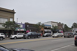
The Williamston Downtown Historic District is a commercial historic district consisting of the first blocks of East and West Grand River Avenue, and the first block of South Putnam Street in Williamston, Michigan. The district was listed on the National Register of Historic Places in 2012.