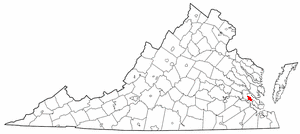
York County is a county in the eastern part of the Commonwealth of Virginia, located in the Tidewater. As of the 2020 census, the population was 70,045. The county seat is the unincorporated town of Yorktown.

Williamsburg is a city in the U.S. state of Virginia. As of the 2020 U.S. Census, it had a population of 15,425. Located on the Virginia Peninsula, Williamsburg is in the northern part of the Hampton Roads metropolitan area. It is bordered by James City County on the west and south and York County on the east.

Newport News is an independent city in the U.S. state of Virginia. As of the 2020 census, the population was 186,247. Located in the Hampton Roads region, it is the 5th most populous city in Virginia and 140th most populous city in the United States.

James City County is a county located in the Commonwealth of Virginia. As of the 2020 census, the population was 78,254. Although politically separate from the county, the county seat is the adjacent independent city of Williamsburg.

Dumfries, officially the Town of Dumfries, is a town in Prince William County, Virginia. The population was 4,961 at the 2010 United States Census.

Hampton Roads is the name of both a body of water that serves as a wide channel for the James, Nansemond and Elizabeth rivers between Old Point Comfort and Sewell's Point where the Chesapeake Bay flows into the Atlantic Ocean, and the surrounding metropolitan region located in the southeastern Virginia and northeastern North Carolina portions of the Tidewater region.

Colonial National Historical Park is located in the Hampton Roads region of Virginia and is operated by the National Park Service of the United States government. The park protects and interprets several sites relating to the Colony of Virginia and the history of the United States more broadly, ranging from the site of the first landing of the English settlers who would settle at Jamestown, to the battlefields of Yorktown where the British Army was finally defeated in the American Revolutionary War. Over 3 million people visit the park each year.

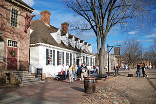
Colonial Williamsburg is a living-history museum and private foundation presenting a part of the historic district in the city of Williamsburg, Virginia, United States. The Colonial Williamsburg Foundation has 7300 employees at this location and globally.. There are 37 companies in The Colonial Williamsburg Foundation corporate family.

Middle Plantation in the Virginia Colony was the unincorporated town established in 1632 that became Williamsburg in 1699. It was located on high ground about halfway across the Virginia Peninsula between the James River and York River. Middle Plantation represented the first major inland settlement for the colony. It was established by an Act of Assembly to provide a link between Jamestown and Chiskiack, a settlement located across the Peninsula on the York River.

Bruton Parish Church is located in the restored area of Colonial Williamsburg in Williamsburg, Virginia, United States. It was established in 1674 by the consolidation of two previous parishes in the Virginia Colony, and remains an active Episcopal parish. The building, constructed 1711–15, was designated a National Historic Landmark in 1970 as a well-preserved early example of colonial religious architecture.

The Wren Building is the signature building of the College of William & Mary in Williamsburg, Virginia. Along with the Brafferton and President's House, these buildings form the College's Ancient Campus. With a construction history dating to 1695, it is the oldest academic building in continuous use in the United States. It was designated a National Historic Landmark in 1960.

Carter's Grove, also known as Carter's Grove Plantation, is a 750-acre (300 ha) plantation located on the north shore of the James River in the Grove Community of southeastern James City County in the Virginia Peninsula area of the Hampton Roads region of Virginia in the United States.

Buildings, sites, districts, and objects in Virginia listed on the National Register of Historic Places:

Historic Jamestown is the cultural heritage site that was the location of the 1607 James Fort and the later 17th-century town of Jamestown in America. It is located on Jamestown Island, on the James River at Jamestown, Virginia and operated as a partnership between Preservation Virginia and the U.S. National Park Service as part of Colonial National Historical Park.

College Creek is located in James City County in the Virginia Peninsula area of the Hampton Roads region of southeastern Virginia in the United States. From a point of origin near the independent city of Williamsburg, it is a tributary of the James River.

The history of Williamsburg, Virginia dates to the 17th Century. First named Middle Plantation, it changed its name to Williamsburg in 1699.

The Peyton Randolph House, also known as the Randolph-Peachy House, is a historic house museum in Colonial Williamsburg, Virginia. Its oldest portion dating to about 1715, it is one of the museum's oldest surviving buildings. It was designated a National Historic Landmark in 1973 as the home of Peyton Randolph (1721–1775), the first and third President of the Continental Congress.

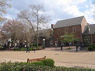
Merchants Square is a 20th-century interpretation of an 18th-century-style retail village in Colonial Williamsburg, Virginia, United States. It is listed on the National Register of Historic Places.

This is a list of the National Register of Historic Places listings in Williamsburg, Virginia.

Whitaker's Mill Archeological Complex, also known as Burwell's Mill, is the site of an early colonial mill complex in York County near Williamsburg. Located on the historic King's Creek Plantation near Route 199 and Water Country Parkway, the site has industrial remains of millworks from the 17th and 18th centuries, as well as military encampment sites associated with the American Revolutionary War and the American Civil War.


