Conestoga Township, Pennsylvania | |
---|---|
Country | United States |
State | Pennsylvania |
County | Lancaster |
Settled | 1759 |
Incorporated | 1712 |
Government | |
• Type | Board of Supervisors [1] |
• Chairman | Matthew Connelly |
• Vice Chairman | Joe Devoy |
• Member | John Berry |
Area | |
• Total | 16.58 sq mi (42.93 km2) |
• Land | 14.64 sq mi (37.91 km2) |
• Water | 1.94 sq mi (5.02 km2) |
Population | |
• Total | 3,922 |
• Estimate (2021) [3] | 3,914 |
• Density | 263.27/sq mi (101.65/km2) |
Time zone | UTC-5 (Eastern (EST)) |
• Summer (DST) | UTC-4 (EDT) |
Area code | 717 |
FIPS code | 42-071-15592 |
Website | conestogatwp |
Conestoga Township is a township in west central Lancaster County, Pennsylvania. At the 2020 census, the population was 3,922. [3]
Conestoga Township was formed in 1712 as part of Chester County. Lancaster County was not formed until 1729. Pequea Township was formed from Conestoga Township. [4]
Conestoga wagons are named for the township; it cannot be proven that the first such wagons were built in the township, but at least some were. [4]
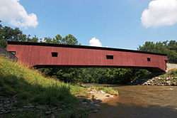
The Colemanville Covered Bridge and Big and Little Indian Rock Petroglyphs are listed on the National Register of Historic Places. [5]
According to the U.S. Census Bureau, the township has a total area of 16.4 square miles (42 km2), of which 14.6 square miles (38 km2) is land and 1.8 square miles (4.7 km2) (11.02%) is water. It includes the communities of Slackwater, Rockhill, Stone Hill, Conestoga, Safe Harbor, and Colemanville.
Census | Pop. | Note | %± |
---|---|---|---|
1980 | 3,032 | — | |
1990 | 3,470 | 14.4% | |
2000 | 3,749 | 8.0% | |
2010 | 3,776 | 0.7% | |
2020 | 3,922 | 3.9% | |
2021 (est.) | 3,914 | [3] | −0.2% |
U.S. Decennial Census [6] |
At the 2000 census, there were 3,749 people, 1,374 households, and 1,067 families living in the township. The population density was 256.3 people per square mile (99.0 people/km2). There were 1,409 housing units at an average density of 96.3 units per square mile (37.2 units/km2). The racial makeup of the township was 98.32% White, 0.32% Black or African American, 0.13% Native American, 0.16% Asian, 0.21% Pacific Islander, 0.13% from other races, and 0.72% from two or more races. 0.99% of the population were Hispanic or Latino of any race. [7] There were 1,374 households, 36.0% had children under the age of 18 living with them, 66.2% were married couples living together, 7.5% had a female householder with no husband present, and 22.3% were non-families. 17.3% of households were made up of individuals, and 5.7% were one person aged 65 or older. The average household size was 2.73 and the average family size was 3.10.
The age distribution was 26.9% under the age of 18, 7.4% from 18 to 24, 29.5% from 25 to 44, 26.3% from 45 to 64, and 9.9% 65 or older. The median age was 38 years. For every 100 females, there were 101.9 males. For every 100 females age 18 and over, there were 102.0 males.
The median household income was $51,895 and the median family income was $57,768. Males had a median income of $37,284 versus $25,956 for females. The per capita income for the township was $21,939. About 2.2% of families and 3.5% of the population were below the poverty line, including 2.2% of those under age 18 and 2.9% of those age 65 or over.
Willow Street is an unincorporated community and census-designated place (CDP) in Lancaster County, Pennsylvania, United States. The population was 7,578 at the 2010 census. In the early part of the 20th century, the main thoroughfare in town was lined with willow trees on both sides for the length of the town, hence the community's name. As time passed and the town grew, the road was widened and sidewalks were installed, which required the trees be removed. Only a few of the original trees remain to this day.
Brickerville is an unincorporated community and census-designated place (CDP) in Elizabeth Township, Lancaster County, Pennsylvania, United States, with a ZIP code of 17543. The population was 1,309 at the 2010 census.
East Lampeter Township is a township in central Lancaster County, Pennsylvania, United States. At the 2020 census, the population was 17,834.
Martic Township is a township in southwestern Lancaster County, Pennsylvania, United States. At the 2020 census, the population was 5,237. Martic Township was organized in 1729. It borders Conestoga, Providence, Pequea and Drumore townships.
East Providence Township is a township in Bedford County, Pennsylvania, United States. The population was 1,756 at the 2020 census. The unincorporated community of Breezewood is in the township, which holds the Township's municipal buildings.
Caernarvon Township is a township in Berks County, Pennsylvania, United States. The population was 4,252 at the 2020 census. It is often referred to as Morgantown, the township's largest village.
East Taylor Township is a township in Cambria County, Pennsylvania, United States, The population was 2,726 at the 2010 census, unchanged since the 2000 census. It is part of the Johnstown, Pennsylvania Metropolitan Statistical Area.
Miles Township is a township in Centre County, Pennsylvania, United States. It is part of the State College, Pennsylvania Metropolitan Statistical Area. The population was 2,013 at the 2020 census, an increase over the figure of 1,983 tabulated in 2010. Miles Township and nearby Milesburg were named after Samuel Miles, who co-owned the Centre Furnace, along with Colonel John Patton.
Gray Township is a township in Greene County, Pennsylvania, United States. The population was 182 at the 2020 census.
Shirley Township is a township in Huntingdon County, Pennsylvania, United States. The population was 2,407 at the 2020 census.
Union Township is a township in Huntingdon County, Pennsylvania, United States. The population was 951 at the 2020 census.
Lancaster Township is a civil township of Lancaster County, Pennsylvania, United States. It is in the central area of the county, and it immediately surrounds Lancaster City. As of the 2020 census, the township population was 18,591.
Manor Township is a second-class township in west-central Lancaster County, Pennsylvania, United States. As of the 2020 census, it had a population of 21,920.
Mountville is a borough in Lancaster County, Pennsylvania, United States. The population was 3,022 at the 2020 census, an increase over the figure of 2,802 tabulated in 2010. The original Charles Chips potato chip factory was located here.
Rothsville is an unincorporated community and census-designated place (CDP) in Warwick Township, Lancaster County, Pennsylvania, United States. The population was 3,044 at the 2010 census. Lititz is the town for residents' mailing addresses.
Warwick Township is a township in north-central Lancaster County, Pennsylvania, United States. The population was 19,068 at the 2020 census. It completely surrounds the borough of Lititz and contains the unincorporated villages of Brunnerville, Disston, Kissel Hill, Lexington, Millway, and Rothsville.
West Earl Township is a township in northeastern Lancaster County, Pennsylvania, United States. The population was 8,565 at the 2020 census. The township was founded by its first settler, Hans Conrad Groff (1661-1746) in 1717.
West Lampeter Township is a township that is located in central Lancaster County, Pennsylvania, United States. The population was 17,365 at the time of the 2020 census.
Point Township is a township in Northumberland County, Pennsylvania, United States. The population at the 2010 Census was 3,685, a decline from the figure of 3,722 tabulated in 2000.
Cranberry is a township in Venango County, Pennsylvania, United States. The population was 6,336 at the 2020 census, a decrease from 6,685 in 2010, which represented a decrease from the figure of 7,014 at the 2000 census.