The Shire of Colac Otway is a local government area in the Barwon South West region of Victoria, Australia, located in the south-western part of the state. It covers an area of 3,433 square kilometres (1,325 sq mi) and at the 2016 Census had a population of almost 21,000. It includes the towns of Apollo Bay, Beeac, Beech Forest, Birregurra, Colac, Cressy, Forrest, Johanna, Kennett River, Lavers Hill, Warrion and Wye River. It was formed in 1994 from the amalgamation of the City of Colac, Shire of Colac, Shire of Otway and part of the Shire of Heytesbury.

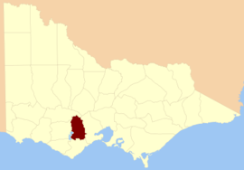
The Golden Plains Shire is a local government area in Victoria, Australia, located in the western part of the state. It covers an area of 2,704 square kilometres (1,044 sq mi) and at the 2016 Census, had a population of over 21,000. It includes the towns of Bannockburn, Gheringhap, Lethbridge, Linton, Berringa, Teesdale, Rokewood and Meredith.

The County of Grant is one of the 37 counties of Victoria which are part of the cadastral divisions of Australia, used for land titles. It is located to the west of Melbourne, on the west side of Port Phillip and includes Geelong. Ballarat is on its north-western edge. It is bounded in the west by the Yarrowee River, on the north by the Great Dividing Range and on the east by the Werribee River. The county was proclaimed in 1853.

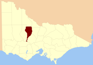
The County of Moira is one of the 37 counties of Victoria which are part of the cadastral divisions of Australia, used for land titles. It is located to the east of the Goulburn River, south of the Murray River, and west of part of the Ovens River. Part of Wangaratta is in the county, on the eastern end of it. It also includes Shepparton. The Shire of Moira is in a similar area.
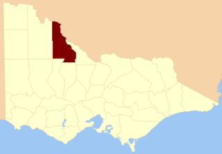
The County of Gladstone is one of the 37 counties of Victoria which are part of the cadastral divisions of Australia, used for land titles. It is located between the Avoca River in the west and Loddon River and Bet Bet Creek in the east. The county was proclaimed in 1870.
The County of Tatchera is one of the 37 counties of Victoria which are part of the cadastral divisions of Australia, used for land titles. It is located to the south of the Murray River, and to the south west of Swan Hill, with its western boundary at 143°E, and part of the southern boundary at 36°S.

The Shire of Leigh was a local government area about 140 kilometres (87 mi) west of Melbourne, the state capital of Victoria, Australia. The shire covered an area of 982 square kilometres (379.2 sq mi), and existed from 1861 until 1994.

The County of Kara Kara is one of the 37 counties of Victoria which are part of the cadastral divisions of Australia, used for land titles. The northern boundary of the county is at 36°S. At the north its western boundary is 143°E. Larger towns include St Arnaud and Donald. The County was proclaimed in 1871 together with the other counties of the Wimmera Land District.
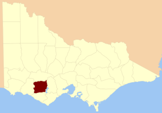
The County of Hampden is one of the 37 counties of Victoria which are part of the cadastral divisions of Australia, used for land titles. The county is in the Western District of Victoria bounded by Lake Corangamite in the east and the Hopkins River in the west. In the north and south the county was bounded approximately by the existing roads, now the Glenelg Highway and the Princes Highway. Larger towns include Terang and Skipton. The county was proclaimed in 1849.
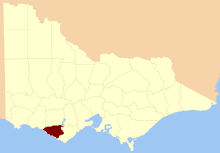
The County of Heytesbury is one of the 37 counties of Victoria which are part of the cadastral divisions of Australia, used for land titles. The county is in the Western District of Victoria bounded by the Gellibrand River in the east and the Hopkins River in the west. In the north, the county was bounded approximately by the existing road, now the Princes Highway. Larger towns include Camperdown and Cobden. The county was proclaimed in 1849.
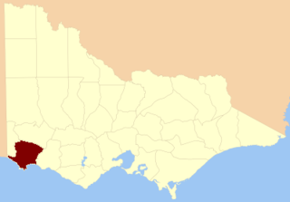
The County of Normanby in Victoria, is one of the 37 counties of Victoria which are part of the cadastral divisions of Australia, used for land titles. The county is in the Western District of Victoria bounded by the Glenelg River in the west and the Eumeralla River in the east, by a line through Casterton and Hamilton in the north, and by Bass Strait to the south. Larger towns include Hamilton, Portland and Heywood. The county was proclaimed in 1853.

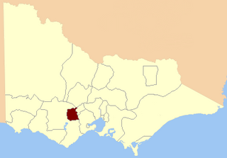
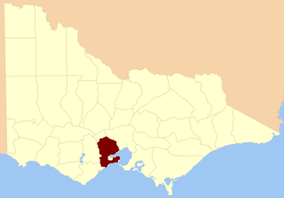
The County of Polwarth is one of the 37 counties of Victoria which are part of the cadastral divisions of Australia, used for land titles. The county is in the Western District of Victoria and includes the Cape Otway area, bounded by the Gellibrand River in the west and the Anglesea River and Barwon River in the east, in the north by a line from Winchelsea, through Colac to Larpent, and by Bass Strait to the south. The largest town is Colac. The county was proclaimed in 1849.
The electoral district of Allandale was an electoral district of the Legislative Assembly in the Australian state of Victoria, located north-west of Ballarat.

The Yarrowee River is a perennial river of the Corangamite catchment, located in the Central Highlands region of the Australian state of Victoria.
North Grenville was an electoral district of the Legislative Assembly in the Australian state of Victoria from 1856 to 1859. It was bordered on the east by the Yarrowee River and included an area south of Ballarat. The district of North Grenville was one of the initial districts of the first Victorian Legislative Assembly, 1856.
South Grant was an electoral district of the Legislative Assembly in the Australian state of Victoria from 1856 to 1877.

The Electoral district of Grant was one of the sixteen electoral districts of the original unicameral Victorian Legislative Council (Australia) of 1851 to 1856.

Grenville was an electoral district of the Legislative Assembly in the Australian state of Victoria from 1859 to 1927. It was located in western Victoria, south of Ballarat.

Polwarth and South Grenville was an electoral district of the Legislative Assembly in the Australian state of Victoria from 1859 to 1889. It was based in western Victoria.

The Leigh River is a perennial river of the Corangamite catchment, located in the Central Highlands region of the Australian state of Victoria.