
The Wilcox, Crittenden Mill, also known as Wilcox, Crittenden Mill Historic District, is a 17-acre (6.9 ha) property in Middletown, Connecticut that was listed on the National Register of Historic Places in 1986. It was the location of the Wilcox, Crittenden company, a marine hardware firm. The historic district listing included four contributing buildings and three other contributing sites.

North Uxbridge is a village and a post office in the town (township) of Uxbridge in Worcester County, Massachusetts, United States. The postal zip code is 01538. It is classified as a community or populated place located at latitude 42.088 and longitude -71.641 and the elevation is 266 feet (81 m). North Uxbridge appears on the Uxbridge U.S. Geological Survey Map. Worcester County is in the Eastern time zone and observes DST. North Uxbridge is located about 36 miles WSW of Boston, and 15 miles SE of Worcester. The town meeting in 1885 set aside North Uxbridge as a "special district", since its population had exceeded 1000 people. North Uxbridge appeared to be a separate Census tract in the 1960 census with a population of 1882. In 2013, an Uxbridge DIY show, The Garage, with Steve Butler, went worldwide from Steve's garage in North Uxbridge.

Ironstone is an historic village,, in the township of Uxbridge, Massachusetts, United States. It derived its name from plentiful bog iron found here which helped Uxbridge to become a center for three iron forges in the town's earliest settlement. South Uxbridge has historic sites, picturesque weddings, hospitality, industrial and distribution centers, and the new Uxbridge High School. This community borders North Smithfield, and Burrillville, Rhode Island, and Millville, Massachusetts. South Uxbridge receives municipal services from Uxbridge, for fire, police, EMS, School district, public works, and other services. There is a South Uxbridge fire station of the Uxbridge fire department. Worcester's Judicial District includes Uxbridge District Court. Ironstone appears on the Blackstone U.S. Geological Survey Map. Worcester County is in the Eastern time zone and observes DST.

The Hope Village Historic District is a historic rural mill settlement within Hope Village in Scituate, Rhode Island. Hope Village is located on a bend in the North Pawtuxet River in the southeastern corner of Scituate. Industrial activity has occurred in Hope Village since the mid-eighteenth century. Surviving industrial and residential buildings in the Historic District date back to the early 19th century. The village center sits at junction of Main Street and North Road. Hope Village radiates out from the center with houses on several smaller side streets in a compact configuration. Currently there is little commercial or industrial activity in Hope Village and none in the Historic District. The present stone mill building on the south side of Hope Village was built in 1844 by Brown & Ives of Providence, expanded in 1871 and modified in 1910. Approximately one quarter of the village's current housing stock was built as mill worker housing by various owners of Hope Mill.

Quinebaug Mill–Quebec Square Historic District is a historic district roughly bounded by the Quinebaug River, Quebec Square, and Elm and S. Main Streets in the town of Brooklyn in Windham County, Connecticut. The district encompasses a well-preserved 19th-century mill village. It was added to the National Register of Historic Places in 1985.
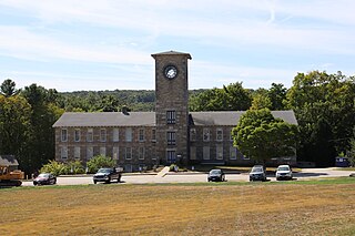
The Mansfield Hollow Historic District encompasses the remnants of a modest 19th-century industrial village on Mansfield Hollow Road in Mansfield, Connecticut. Originally industrialized with saw and grist mills, a silk mill was added in 1838, when it its most significant growth began. The surviving stone mill was built in 1882, and there are a number of nearby houses dating to the industrial period. The district was listed on the National Register of Historic Places in 1979.

The Talcottville Historic District is a historic district in the town of Vernon, Connecticut. Centered on Elm Hill Road and Main Street, it encompasses a 19th-century mill village, including archaeological remnants of very early cotton-spinning facilities, and old stone dam, and a major wood-frame mill constructed by the Talcott brothers. Also included in the village are a significant number of mill worker housing units, many dating to the middle decades of the 19th century, and an 1891 lenticular pony truss bridge, built by the Berlin Iron Bridge Company. The district was listed on the National Register of Historic Places in 1989.

The Hotchkissville Historic District is a historic district in the town of Woodbury, Connecticut, that was listed on the National Register of Historic Places in 1995. The district encompasses most of the historic village of Hotchkissville, which is centered at the junction of Washington and Weekeepeemee roads. The village began as a dispersed rural agricultural community, but developed in the 19th century with the arrival of industry, primarily the manufacture of textiles. Despite this, the village has retained a significantly rural character, and includes a broad cross-section of 18th- and 19th-century architectural styles.
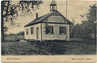
The West Goshen Historic District is a historic district in the village of West Goshen in the town of Goshen, Connecticut. It encompasses a well-preserved early 19th-century industrial village, with twenty historically significant properties in the village, most of which lie on Connecticut Route 4 between Beach Street and Thompson Road. The district was listed on the National Register of Historic Places in 1987.

The Central Village Historic District is a historic district in the Central Village area of Plainfield, Connecticut that was listed on the National Register of Historic Places (NRHP) in 1991. It encompasses a late 19th-century historic mill village, including a small commercial center where Connecticut Route 12 and 14 meet, a cluster of architecturally distinguished buildings built by mill owners and managers, and a collection of mill worker housing units. It includes the Plainfield Woolen Company Mill, which is separately listed, as well as archaeological remnants of other mill infrastructure. It also includes Plainfield's old town hall and high school. Other architecturally prominent buildings include the c. 1855 Italianate mansion of mill owner Arthur Fenner, and the 1845 Greek Revival Congregational Church.
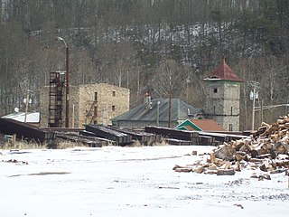
Daniels Mill is a historic mill complex located at Daniels, Howard County, Maryland, in a sheltered, wooded valley of the upper Patapsco River. The complex consists of seven early industrial structures, several concrete block and brick structures of 20th century date, and Gary Memorial United Methodist Church, a granite church built in the High Victorian Gothic style with an off-center tower entrance on the west gable. South of the church is a small cemetery.

The Hamilton Woolen Company Historic District encompasses the well preserved "Big Mill" complex of the Hamilton Woolen Company, built in the mid 19th century. Located at the confluence of McKinstry Brook and the Quinebaug River in central Southbridge, Massachusetts, the complex consists of a cluster of mill buildings and a rare collection of 1830s brick mill worker housing units located nearby. The district was listed on the National Register of Historic Places in 1989.

The Hemlock Glen Industrial Archeological District is a historic industrial archaeological site in Hampton, Connecticut. It consists of a series of mill sites on a tributary of the Shetucket River that operated from the mid-18th to early 20th centuries. The district was added to the National Register of Historic Places in 2007.

Hallville Mill Historic District is a historic district in the town of Preston, Connecticut, that was listed on the National Register of Historic Places in 1996. Contributing properties in the district are 23 buildings, two other contributing structures, and one other contributing site over a 50-acre (20 ha) area. The district includes the dam that forms Hallville Pond, historic manufacturing buildings and worker housing, and the Hallville Mill Bridge, a lenticular pony truss bridge built circa 1890 by the Berlin Iron Bridge Company.
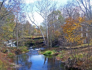
The Bloomvale Historic District is located east of the hamlet of Salt Point, New York, United States. It is a collection of buildings and structures around the intersection of Clinton Corners Road, state highway NY 82 and the East Branch of Wappinger Creek. Most of it is in the Town of Pleasant Valley; the eastern portion is in the Town of Washington.

The Valley Falls Cotton Mill Site is the site of a historic mill at Valley Falls Park in Vernon, Connecticut. Mills were operated on the site from colonial times until 1877, when the last mill burned. The site was listed on the National Register of Historic Places in 1997.
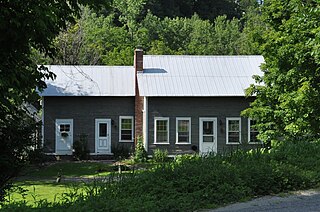
The Royalton Mill Complex is a three-building residential site in what is now a rural setting of Royalton, Vermont. The two houses and barn are historically associated with a mill, whose breached dams and remnant foundations lie just to the north. One of the houses, built about 1780, is believed to be Royalton's oldest surviving building. The complex was listed on the National Register of Historic Places in 1983.

The South Willington Historic District is a historic district encompassing the historic village of South Willington in the town of Willington, Connecticut. The village, mostly stretched along Connecticut Route 32, developed as a 19th-century industrial mill village associated with the Gardiner Hall Jr. Company. The district was listed on the National Register of Historic Places in 2017.

The Cargill Falls Mill, also known historically as the Wilkinson Mill, is a historic textile mill complex at 52-58 Pomfret Street in Putnam, Connecticut. Founded in 1806, it is one of the state's oldest mill complexes, and it retains examples of mill architecture spanning more than 175 years. It was listed on the National Register of Historic Places in 2014.
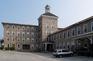
The Manchaug Village Historic District is a historic district encompassing the 19th century industrial village center of Manchaug in Sutton, Massachusetts. Developed in the 1820s around textile mills on the Mumford River, it was the largest industrial area in Sutton, with at least three mill complexes in operation. The district is centered on the junction of Main Street with Manchaug, Putnam Hill, and Whitins Roads.


