Moran State Park is a public recreation area on Orcas Island in Puget Sound's San Juan Islands in the state of Washington, United States. The state park encompasses over 5,000 acres of various terrain including forests, wetlands, bogs, hills, and lakes. It is the largest public recreation area in the San Juan Islands and the fourth largest state park in the state. A park focal point is the observation tower atop Mount Constitution.

Lime Kiln Point State Park is a 42-acre Washington state park on the western shore of San Juan Island in the San Juan archipelago. The park is considered one of the best places in the world to view wild orcas from a land-based facility. Due to the unique bathymetric properties of the site, visitors on the shore can be within 20 feet of whales jumping out of the water. The park was the site of lime kilns beginning in 1860, and one kiln has been restored as a public exhibit.

Jones Island State Park is a Washington state park coterminous with Jones Island, one of the San Juan Islands in San Juan County, Washington, USA. It is located one mile (1.6 km) west of the southwestern corner of Orcas Island and accessible only by boat. The island has a land area of 188 acres (76 ha) and no resident population. The island was named by the Wilkes Expedition in 1841 for naval officer Jacob Jones.

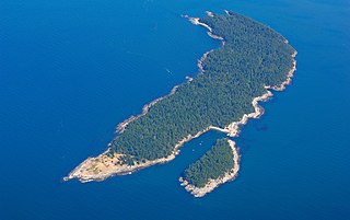
James Island is one of the San Juan Islands in San Juan County, Washington, United States. It lies in Rosario Strait just off the eastern shore of Decatur Island and west of the city of Anacortes. The entire island comprises James Island State Park of the Washington State Park System. It has a land area of 113 acres (46 ha) with 12,335 feet (3,760 m) of saltwater shoreline. The island has no potable water or residents. It has three different camping areas, each with at least one toilet. The camping areas combine for a total of 13 campsites and are connected by a loop trail. James Island was named by Charles Wilkes in 1841 to commemorate the naval hero Reuben James. The property was transferred from the federal government to the Washington State Parks and Recreation Commission in 1964.
Skull Island is the name of two small islands in the San Juan Archipelago in the U.S. state of Washington. The northernmost Skull Island is located off the coast of Orcas Island in Massacre Bay, the most northern extension of the island's West Sound. It is identified as 3.7-acre (1.5 ha) Skull Island State Park Property by the Washington State Parks and Recreation Commission. It was named for holding skulls and bones of a band of Lummi who were killed by raiding Haida in 1858. Since 2013, it has been part of the San Juan Islands National Monument.

Birch Bay State Park is a 194-acre (79 ha) Washington state park located nine miles (14 km) south of Blaine in Whatcom County. The park has 8,255 feet (2,516 m) of saltwater shoreline on Birch Bay and 15,000 feet (4,600 m) of freshwater shoreline along Terrell Creek. Recreational opportunities include camping, picnicking, fishing, hiking, crabbing, clamming, and boating.
Turn Island is a 34-acre (14 ha) island in the San Juan Islands in the Salish Sea in the U.S. state of Washington. The island sits in the San Juan Channel about 900 feet off the eastern edge of San Juan Island. It is preserved as Turn Island Marine State Park and is part of the San Juan Islands National Wildlife Refuge. The island has 12 campsites and is only accessible by water.
Patos Island is a small island in the San Juan Islands of the U.S. state of Washington. Since 1893, it has been home to the Patos Island Lighthouse, guiding vessels through Boundary Pass between Canada and the United States. The name comes from the Spanish pato, meaning "duck," which was given to the island in 1792 by Commander Dionisio Alcalá Galiano of the Sutil and Captain Cayetano Valdés y Flores of the Mexicana.

Matia Island is an island in the San Juan Islands of the U.S. state of Washington. The island's entire 145 acres (59 ha) comes under the protection of the U.S. Fish and Wildlife Service and is cooperatively managed by the Washington State Parks and Recreation Commission. Matia Island is a National Wildlife Refuge, part of the San Juan Islands National Wildlife Refuge. A 2-acre (0.81 ha) camping area around Rolfe Cove is managed as a State Marine Park by the Washington State Parks and Recreation Commission under an agreement dating back to 1959. Pets, wood collecting, and campfires are not allowed on the island. Except for the Wilderness Loop Trail and the campground, all areas above the high tide line are closed to the public.

Clark Island is an island in the San Juan Islands of the U.S. state of Washington. It is located near Barnes Island off the northeast coast of Orcas Island. Clark Island Marine State Park, which encompasses the entire 55-acre (22 ha) island, has two picnicking sites, 15 primitive campsites, and nine mooring buoys.

The San Juan Islands National Wildlife Refuge is in the San Juan Islands of the Salish Sea, north of Puget Sound, in the State of Washington. Created in 1976, it comprises 83 small, uninhabited islands, scattered throughout the San Juans, with a combined area of approximately 454 acres (1.84 km2). The Refuge is managed by the U.S. Fish and Wildlife Service.
Blind Island State Park is a public recreation area consisting of three-acre (1.2 ha) Blind Island in San Juan County, Washington. The island lies off Shaw Island near the entrance to Blind Bay and is part of San Juan Islands National Monument. It has about 1,280 feet (390 m) of saltwater shoreline and is part of the Cascadia Marine Trail, with all campsites restricted to visitors arriving in non-motorized watercraft. It became a state park in 1970 under lease from the U.S. Bureau of Land Management and is cooperatively managed by the BLM and Washington State Parks.
Eagle Island State Park is a public recreation area in south Puget Sound occupying the entirety of Eagle Island in Pierce County, Washington. The five-acre (2.0 ha) island sits in Balch Passage between McNeil and Anderson islands about 750 feet (230 m) off Anderson Island's north shore. The island was named for Harry Eagle, one of the party members of the Wilkes Expedition of 1841.
McMicken Island Marine State Park is a public recreation area on Harstine Island in south Puget Sound, Mason County, Washington. The state park's 222 acres (90 ha) include 11.5 acres (4.7 ha) of forested McMicken Island and 1,661 feet (506 m) of saltwater shoreline with a sheltered cove. A sand bar connects McMicken Island to Harstine Island at low tide. Park activities include hiking, boating, and harvesting shellfish. The park is administered as a satellite of Jarrell Cove State Park. It bears the name of William C. McMicken, who was Washington Surveyor General from 1873 to 1886.
Stretch Point State Park is a public recreation area occupying eight acres (3.2 ha) of land on the northern tip of Stretch Island in Mason County, Washington. The state park is only accessible by boat and is administered as a satellite of Jarrell Cove State Park.

Posey Island State Park is a public recreation area consisting of 1-acre (0.40 ha) Posey Island in San Juan County, Washington. The island is located .25 miles (0.40 km) north of Pearl Island, near Roche Harbor, San Juan Island. It has about 1,000 feet (300 m) of saltwater shoreline and is part of the Cascadia Marine Trail, with campsites restricted to visitors arriving in non-motorized watercraft. The island-park is managed by the Washington State Parks and Recreation Commission. It became a state park in 1960 under lease from the U.S. Bureau of Land Management.
Stuart Island State Park in San Juan County, Washington is a marine camping park in the Washington State Park System. It consists of 433 acres (175 ha) of land and waterways on and around Stuart Island, named for Frederick D. Stuart, clerk to explorer Charles Wilkes.
Upright Channel Park is a former unit of the Washington State Park System consisting of 20 acres (8.1 ha) of island, beach, and tidelands on Upright Channel in the northwest corner of Lopez Island. The park was not listed as a Washington State Parks property as of March 2014. San Juan County assumed management of the property per a Memorandum of Understanding in May 2014.
Saddlebag Island Marine State Park is a public recreation area made up of 26-acre (11 ha) Saddlebag Island, part of the San Juan Islands, in Skagit County, Washington. The island sits in Padilla Bay four miles (6.4 km) northeast of Anacortes, Washington. Dot Island and Huckleberry Island lie nearby. Saddlebag Island was held in private ownership until 1974, when the state purchased it for $192,000 for use as a state park.