| Drumcondra Geelong, Victoria | |||||||||||||||
|---|---|---|---|---|---|---|---|---|---|---|---|---|---|---|---|
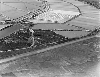
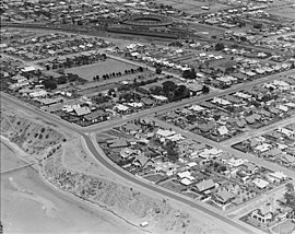 The Esplanade, Drumcondra in 1927. The railway roundhouse at the Geelong West locomotive depot is visible in the background. | |||||||||||||||
 Drumcondra | |||||||||||||||
| Coordinates | 38°07′55″S144°21′14″E / 38.132°S 144.354°E Coordinates: 38°07′55″S144°21′14″E / 38.132°S 144.354°E | ||||||||||||||
| Population | 560 (2016 census) [1] | ||||||||||||||
| • Density | 1,900/km2 (4,800/sq mi) | ||||||||||||||
| Postcode(s) | 3215 | ||||||||||||||
| Area | 0.3 km2 (0.1 sq mi) | ||||||||||||||
| LGA(s) | City of Greater Geelong | ||||||||||||||
| State electorate(s) | Lara | ||||||||||||||
| Federal Division(s) | Corio | ||||||||||||||
| |||||||||||||||
Drumcondra is a wealthy residential bayside suburb of Geelong, Victoria, Australia, overlooking Corio Bay. It is the smallest suburb in Geelong and one of the smallest in Victoria. It was named after Drumcondra in Ireland. At the 2016 census, Drumcondra had a population of 560. [1]

Geelong is a port city located on Corio Bay and the Barwon River, in the state of Victoria, Australia. Geelong is 75 kilometres (47 mi) south-west of the state capital, Melbourne. It is the second largest Victorian city, with an estimated urban population of 192,393 as of June 2016.

Victoria is a state in south-eastern Australia. Victoria is Australia's smallest mainland state and its second-most populous state overall, thus making it the most densely populated state overall. Most of its population lives concentrated in the area surrounding Port Phillip Bay, which includes the metropolitan area of its state capital and largest city, Melbourne, Australia's second-largest city. Victoria is bordered by Bass Strait and Tasmania to the south, New South Wales to the north, the Tasman Sea to the east, and South Australia to the west.

Australia, officially the Commonwealth of Australia, is a sovereign country comprising the mainland of the Australian continent, the island of Tasmania and numerous smaller islands. It is the largest country in Oceania and the world's sixth-largest country by total area. The neighbouring countries are Papua New Guinea, Indonesia and East Timor to the north; the Solomon Islands and Vanuatu to the north-east; and New Zealand to the south-east. The population of 25 million is highly urbanised and heavily concentrated on the eastern seaboard. Australia's capital is Canberra, and its largest city is Sydney. The country's other major metropolitan areas are Melbourne, Brisbane, Perth and Adelaide.
Its boundaries are the Melbourne Road, Glenleith Avenue, The Esplanade and Bell Parade. It is classified as a "block" with its main road being Beach Parade, with only 9 streets in total and around 200 houses. Some of Geelong's most-prized and valuable real estate is located along here. [2]
The area was established with the first house built on the site of 5 Glenleith Avenue in April 1912. The houses then were continued to be built on that street in that year, making 2012 their 100th anniversary.
The mansion Lunan House is located in the suburb, built of Barrabool sandstone for wool merchant James Strahan in 1849. In later years it became a teachers college, before being converted back to a private house. The house is listed on the Victorian Heritage Register. [3]

The Victorian Heritage Register (VHR) lists places deemed to be of cultural heritage significance to the State of Victoria, Australia. It has statutory weight under the Heritage Act 1995 which established Heritage Victoria as the State Government listing and permit authority. Listing on the Victorian Heritage Register is separate from listing by a local Council or Shire, known as a Heritage Overlay. Heritage Victoria is currently part of the Department of Environment, Land, Water and Planning of the Government of Victoria, Australia. Heritage Victoria reports to the Heritage Council who approve recommendations to the Register and hear appeals when a registration is disputed. The Council also hears appeals by an owner to a permit issued by Heritage Victoria. The Minister for Planning is the responsible Minister for Heritage Victoria and the Heritage Act 1995. As of 2013, there were over 2,200 places and objects listed on the VHR.
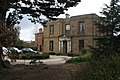 Lunan House