East Barron, Queensland

Last updated

East Barron
Queensland
CSIRO ScienceImage 4061 Farmer hilling his potato crop between East Barron and Stonehouse Roads Atherton QLD.jpg
Potato crop, East Barron area, 1998
Australia Queensland location map.svg
Red pog.svg
East Barron
Coordinates 17°18′07″S145°32′39″E / 17.3019°S 145.5441°E / -17.3019; 145.5441 (East Barron (centre of locality))
Population278 (2021 census) [1]
 • Density6.950/km2 (18.00/sq mi)
Postcode(s) 4883
Area40.0 km2 (15.4 sq mi)
Time zone AEST (UTC+10:00)
Location
LGA(s) Tablelands Region
State electorate(s) Hill
Federal division(s) Kennedy
Suburbs around East Barron:
Kairi Lake Tinaroo Yungaburra
Atherton East Barron Peeramon
Wongabel Upper Barron Upper Barron

East Barron is a rural locality in the Tablelands Region, Queensland, Australia. [2] In the 2021 census, East Barron had a population of 278 people. [1]

Contents

Geography

The Barron River forms most of the western boundary of the locality flowing into Lake Tinaroo (created by the Tinaroo Dam) which then forms the northern boundary of the locality. Peterson Creek, also flowing into Lake Tinaroo, forms the north-east boundary of the locality, while Gwynne Creek forms the south-western boundary of the locality, before crossing the locality to become a tributary of the Barron River. [3]

The elevation ranges from 680 metres (2,230 ft) in the north of the locality near Lake Tinaroo to 800 metres (2,600 ft) in the south of the locality. There is small chain of hills known as The Pinnacles in the north of the locality with heights up to 790 to 810 metres (2,590 to 2,660 ft). [3]

The Curtin Fig National Park and (despite the name) the Yungaburra National Park are in the east of the locality. [4] Apart from these protected areas, the land is used for grazing on native vegetation and growing a variety of crops including sugarcane. [5]

In the north of the locality, the Gilles Range Road enters the locality from the north-east (Yungaburra) and exits to the west (Atherton). Further south, the Malanda–Atherton Road enters the locality from the south-east (Upper Barron) and exits to the west (Atherton). [6]

History

East Barron State School opened on 28 April 1915 and closed on 1964. [7] [8] It was at 331 East Barron Road ( 17°19′25″S145°31′49″E / 17.32364°S 145.53029°E / -17.32364; 145.53029 (East Barron State School (former)) ). [9] [10] [11]

Demographics

In the 2016 census, East Barron had a population of 234 people. [12]

In the 2021 census, East Barron had a population of 278 people. [1]

Heritage listings

Curtain fig tree, 2015 THE CURTAIN FIG TREE.jpg
Curtain fig tree, 2015

East Barron has a number of heritage-listed sites, including:

Education

There are no schools in East Barron. The nearest government primary schools are Yungaburra State School in neighbouring Yungaburra to the east and Malanda State School in Malanda to the south-east. The nearest government secondary schools are Atherton State High School in Atherton to the west and Malanda State High School in Malanda to the south-east. [13] [14]

Attractions

The Curtain Fig Tree is a very large example of a strangler fig and is estimated to be over 500 years old ( 17°17′09″S145°34′25″E / 17.2858°S 145.5735°E / -17.2858; 145.5735 (The Curtain Fig Tree) ). [15]

Related Research Articles

<span class="mw-page-title-main">Yungaburra</span> Town in Queensland, Australia

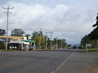
Yungaburra is a rural town and locality in the Tablelands Region, Queensland, Australia. In the 2021 census, the locality of Yungaburra had a population of 1,272 people.

<span class="mw-page-title-main">Atherton Tableland</span> Fertile plateau in northern Queensland, Australia

The Atherton Tableland is a fertile plateau, which is part of the Great Dividing Range in Queensland, Australia. It has very deep, rich basaltic soils and the main industry is agriculture. The principal river flowing across the plateau is the Barron River, which was dammed to form the irrigation reservoir named Lake Tinaroo. Unlike many other rural areas, the Tablelands is experiencing a significant growth in population.

<span class="mw-page-title-main">Atherton, Queensland</span> Town in Queensland, Australia

Atherton is a rural town and locality in the Tablelands Region, Queensland, Australia. In the 2021 census, the locality of Atherton had a population of 7,724 people.

<span class="mw-page-title-main">Tolga, Queensland</span> Town in Queensland, Australia

Tolga is a rural town and locality in the Tablelands Region, Queensland, Australia. In the 2021 census, the locality of Tolga had a population of 3,177 people.

<span class="mw-page-title-main">Tinaroo Dam</span> Dam in Far North Queensland

The Tinaroo Dam, officially the Tinaroo Falls Dam, is a major ungated concrete gravity dam with a central ogee spillway across the Barron River located on the Atherton Tableland in Far North Queensland, Australia. The dam's purpose includes irrigation for the Mareeba-Dimbulah Irrigation Scheme, water supply, hydroelectricity generation, and recreation. Completed between 1953 and 1958, the dam creates the impounded reservoir, Lake Tinaroo.

<span class="mw-page-title-main">Tinaroo, Queensland</span> Suburb of Tablelands Region, Queensland, Australia

Tinaroo is a rural locality in the Tablelands Region, Queensland, Australia. In the 2021 census, Tinaroo had a population of 293 people.

<span class="mw-page-title-main">Malanda, Queensland</span> Town in Queensland, Australia

Malanda is a rural town and locality in the Tablelands Region, Queensland, Australia. In the 2021 census, the locality of Malanda had a population of 2,000 people. The economy is based upon agriculture and tourism.

<span class="mw-page-title-main">Curtain Fig Tree</span> Historic site in Queensland, Australia

"Layers: Locality; Population centres; Heritage register". Queensland Globe. Queensland Government. Retrieved 28 July 2024.

<span class="mw-page-title-main">Shire of Eacham</span> Local government area in Queensland, Australia

The Shire of Eacham was a local government area of Queensland. It was located on the Atherton Tableland, a plateau forming part of the Great Dividing Range west of the city of Cairns. The shire, administered from the town of Malanda, covered an area of 1,126.4 square kilometres (434.9 sq mi), and existed as a local government entity from 1910 until 2008, when it amalgamated with several other councils in the Tableland area to become the Tablelands Region.

<span class="mw-page-title-main">Gillies Highway</span>

The Gillies Highway is a road that runs from Gordonvale in the Cairns Region through the Gillies Range to Atherton in the Tablelands Region, both in Queensland, Australia. Its official name is Gillies Range Road, and it was originally known as the Cairns Range Road.

<span class="mw-page-title-main">Tablelands Region</span> Local government area in Queensland, Australia

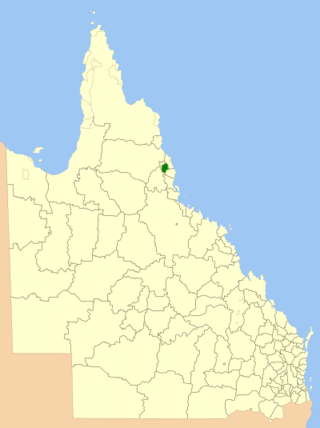
The Tablelands Region is a local government area in Far North Queensland, Australia inland from the city of Cairns. Established in 2008, it was preceded by four previous local government areas which dated back more than a century. On 1 January 2014, one of those local government areas, the Shire of Mareeba, was re-established independent of the Tablelands Region.

<span class="mw-page-title-main">Lake Eacham, Queensland</span> Suburb of Tablelands Region, Queensland, Australia

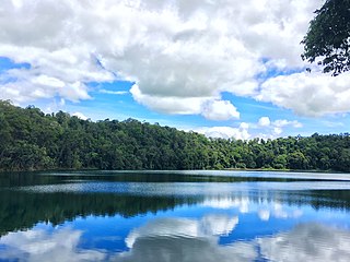
Lake Eacham is a rural locality in the Tablelands Region, Queensland, Australia. In the 2021 census, Lake Eacham had a population of 459 people.

Barrine is a rural locality in the Tablelands Region, Queensland, Australia. In the 2021 census, Barrine had a population of 303 people.

<span class="mw-page-title-main">Lake Barrine, Queensland</span> Suburb of Tablelands Region, Queensland, Australia

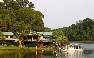
Lake Barrine is a rural locality in the Tablelands Region, Queensland, Australia. In the 2021 census, Lake Barrine had a population of 170 people.

<span class="mw-page-title-main">Peeramon</span> Town in Queensland, Australia

Peeramon is a rural town and locality in the Tablelands Region, Queensland, Australia. In the 2021 census, the locality of Peeramon had a population of 778 people.

<span class="mw-page-title-main">Tarzali</span> Town in Queensland, Australia

Tarzali is a rural town and locality in the Tablelands Region, Queensland, Australia. In the 2021 census, the locality of Tarzali had a population of 431 people.

<span class="mw-page-title-main">Upper Barron</span> Suburb of Tablelands Region, Queensland, Australia

Upper Barron is a rural locality in the Tablelands Region, Queensland, Australia. In the 2021 census, Upper Barron had a population of 503 people.

<span class="mw-page-title-main">Danbulla, Queensland</span> Suburb of Tablelands Region, Queensland, Australia

Danbulla is a locality in the Tablelands Region, Queensland, Australia. In the 2021 census, Danbulla had a population of 88 people.

Moregatta is a rural locality in the Tablelands Region, Queensland, Australia. In the 2021 census, Moregatta had a population of 62 people.

Atherton–Malanda–Millaa Millaa Road is a continuous 39.0-kilometre (24.2 mi) road route in the Tablelands local government area of Queensland, Australia. It has two official names, Malanda–Atherton Road and Millaa Millaa–Malanda Road. The entire route is signed as part of State Route 25. Malanda–Atherton Road is a state-controlled district road, while Millaa Millaa–Malanda Road is part regional and part district.

References

  1. 1 2 3 Australian Bureau of Statistics (28 June 2022). "East Barron (SAL)". 2021 Census QuickStats. Retrieved 28 February 2023. OOjs UI icon edit-ltr-progressive.svg
  2. "East Barron – locality in Tablelands Region (entry 48614)". Queensland Place Names. Queensland Government . Retrieved 29 December 2020.
  3. 1 2 "Layers: Locality; Mountains and ranges; Contours; Watercourses". Queensland Globe. Queensland Government. Archived from the original on 19 December 2017. Retrieved 28 July 2024.
  4. "Layers: Locality; Protected areas and forests; Land use". Queensland Globe. Queensland Government. Archived from the original on 19 December 2017. Retrieved 28 July 2024.
  5. "Layers: Locality; Protected areas and forests; Land use; Sugarcane area". Queensland Globe. Queensland Government. Archived from the original on 19 December 2017. Retrieved 28 July 2024.
  6. Google (10 August 2023). "East Barron, Queensland" (Map). Google Maps . Google. Retrieved 10 August 2023.
  7. Queensland Family History Society (2010), Queensland schools past and present (Version 1.01 ed.), Queensland Family History Society, ISBN   978-1-921171-26-0
  8. "NEW SCHOOLS". The Telegraph . No. 13, 206. Queensland, Australia. 19 March 1915. p. 2. Retrieved 3 September 2023 via National Library of Australia.
  9. "Bartle Frere" (Map). Queensland Government. 1943. Archived from the original on 8 October 2023. Retrieved 5 December 2023.
  10. "Queensland Two Mile series sheet 2m404" (Map). Queensland Government. 1943. Archived from the original on 8 October 2023. Retrieved 5 December 2023.
  11. "Queensland Globe". State of Queensland . Retrieved 5 December 2023.
  12. Australian Bureau of Statistics (27 June 2017). "East Barron (SSC)". 2016 Census QuickStats. Retrieved 20 October 2018. OOjs UI icon edit-ltr-progressive.svg
  13. 1 2 "The Curtain Fig Tree (entry 602734)". Queensland Heritage Register . Queensland Heritage Council. Retrieved 28 July 2024.
  14. "Layers: Locality; Schools and school catchments". Queensland Globe. Queensland Government. Archived from the original on 19 December 2017. Retrieved 28 July 2024.
  15. "Tourist points - Queensland". Queensland Open Data. Queensland Government. 18 November 2020. Archived from the original on 24 November 2020. Retrieved 24 November 2020.