
Yungaburra is a rural town and locality in the Tablelands Region, Queensland, Australia. In the 2016 census, the locality of Yungaburra had a population of 1,239 people.

The Atherton Tableland is a fertile plateau, which is part of the Great Dividing Range in Queensland, Australia. It has very deep, rich basaltic soils and the main industry is agriculture. The principal river flowing across the plateau is the Barron River, which was dammed to form the irrigation reservoir named Lake Tinaroo. Unlike many other rural areas, the Tablelands is experiencing a significant growth in population.

Atherton is a rural town and locality in the Tablelands Region, Queensland, Australia. In the 2016 census, Atherton had a population of 7,331 people.

Lake Barrine is a freshwater lake on the eastern parts of Atherton Tableland in the locality of Lake Barrine, in the Tablelands Region of Far North Queensland, Australia, close to Lake Eacham. The lake and surrounds are protected within the Crater Lakes National Park and are accessible via the Gillies Highway.

The Pinnacles are a series of seven volcanic cinder cones on the Atherton Tableland, near Yungaburra, Queensland, Australia. They were formed more than 350,000 years ago.

Malanda is a rural town and locality in the Tablelands Region, Queensland, Australia. In the 2016 census, the locality of Malanda had a population of 1,985 people. The economy is based upon agriculture and tourism.
The Mount Hypipamee Crater, also known as The Crater, is a huge diatreme located south-east of Herberton on the Atherton Tableland in Far North Queensland, Australia. It is 61 metres in diameter and 82 metres deep.
The Shire of Eacham was a local government area of Queensland. It was located on the Atherton Tableland, a plateau forming part of the Great Dividing Range west of the city of Cairns. The shire, administered from the town of Malanda, covered an area of 1,126.4 square kilometres (434.9 sq mi), and existed as a local government entity from 1910 until 2008, when it amalgamated with several other councils in the Tableland area to become the Tablelands Region.

The Shire of Atherton was a local government area of Queensland. It was located on the Atherton Tableland, a plateau forming part of the Great Dividing Range west of the city of Cairns. The shire, administered from the town of Atherton, covered an area of 623.1 square kilometres (240.6 sq mi), and existed as a local government entity from 1881 until 2008, when it amalgamated with several other councils in the Tableland area to become the Tablelands Region.

The Gillies Highway is a road that runs from Gordonvale in the Cairns Region through the Gillies Range to Atherton in the Tablelands Region, both in Queensland, Australia. Its official name is Gillies Range Road, and it was originally known as the Cairns Range Road.

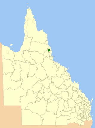
The Tablelands Region is a local government area in Far North Queensland, Australia inland from the city of Cairns. Established in 2008, it was preceded by four previous local government areas which dated back more than a century. On 1 January 2014, one of those local government areas, the Shire of Mareeba, was re-established independent of the Tablelands Region.
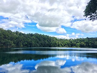
Lake Eacham is a rural locality in the Tablelands Region, Queensland, Australia. In the 2021 census, Lake Eacham had a population of 459 people.

Gunnawarra is a rural locality in the Tablelands Region, Queensland, Australia. In the 2021 census, Gunnawarra had a population of 27 people.

Lake Eacham Hotel is a heritage-listed hotel at 6–8 Kehoe Place, Yungaburra, Tablelands Region, Queensland, Australia. It was built in 1910 by Side Brothers. It was added to the Queensland Heritage Register on 21 October 1992.

Yungaburra Community Centre is a heritage-listed community hall at 19 Cedar Street, Yungaburra, Tablelands Region, Queensland, Australia. It was built from 1910 to c. 1926. It is also known as Tivoli picture theatre, Williams Estate Hall, and Yungaburra Hall. It was added to the Queensland Heritage Register on 21 October 1992.

Gadgarra is a rural locality in the Tablelands Region, Queensland, Australia. In the 2021 census, Gadgarra had "no people or a very low population".

Peeramon is a rural town and locality in the Tablelands Region, Queensland, Australia. In the 2016 census, the locality of Peeramon had a population of 628 people.

Upper Barron is a rural locality in the Tablelands Region, Queensland, Australia. In the 2021 census, Upper Barron had a population of 503 people.
Lamb Range is a locality in the Cairns Region, Queensland, Australia. In the 2021 census, Lamb Range had a population of 7 people.

Danbulla is a locality in the Tablelands Region, Queensland, Australia. In the 2021 census, Danbulla had a population of 88 people.


