Peeramon

Last updated

Map all coordinates using: OpenStreetMap  
Download coordinates as: KML
Peeramon
Queensland
Queensland State Archives 1269 Mr R Campbells Dairy Peeramon Atherton c 1935.png
Mr R Campbell's Dairy, Peeramon, circa 1935
Australia Queensland location map.svg
Red pog.svg
Peeramon
Coordinates 17°18′35″S145°36′43″E / 17.3097°S 145.6119°E / -17.3097; 145.6119 (Peeramon (town centre)) Coordinates: 17°18′35″S145°36′43″E / 17.3097°S 145.6119°E / -17.3097; 145.6119 (Peeramon (town centre))
Population628 (2016 census) [1]
 • Density22.11/km2 (57.27/sq mi)
Postcode(s) 4885
Area28.4 km2 (11.0 sq mi)
Time zone AEST (UTC+10:00)
Location
LGA(s) Tablelands Region
State electorate(s) Hill
Federal division(s) Kennedy
Localities around Peeramon:
East Barron Yungaburra Lake Eacham
Upper Barron Peeramon Lake Eacham
Kureen Kureen Malanda

Peeramon is a rural town and locality in the Tablelands Region, Queensland, Australia. [2] [3] In the 2016 census, the locality of Peeramon had a population of 628 people. [1]

Contents

Geography

The locality is bounded to the east by Lake Barrine Road and to the south-east by the Johnstone River. [4]

There are a number of neighbourhoods in Peeramon (from north-west to south-east):

Mount Quincan ( 17°18′03″S145°34′38″E / 17.3007°S 145.5772°E / -17.3007; 145.5772 (Mount Quincan) ) is in the north-west of the locality and rises to 889 metres (2,917 ft) above sea level. [8] [9]

History

The town's name is an Aboriginal word, referring to a local hill. The name was assigned by the Queensland Railways Department on 25 April 1910. [2]

Lake Eacham State School opened on 1911. It was built by the Sydes Brothers, [10] who were chosen from the tenders called in September 1910. [11] A teacher's residence was built in 1917. [12] In 1919, it was renamed Peeramon State School. It closed in 1959. [13] It was at 107 Mckenzie Road (corner Peeramon School Road, 17°18′36″S145°37′26″E / 17.3099°S 145.6239°E / -17.3099; 145.6239 (Peeramon State School) ). [14] [15]

The Millaa Millaa branch railway opened from Yungaburra to Kureen (via Peeramon) on 18 October 1910.

The Peeramon Methodist Church opened on Thursday 1 August 1918. [16]

In the 2016 census, the locality of Peeramon had a population of 628 people. [1]

Education

There are no schools in Peeramon. The nearest government primary schools are Yunaburra State School in neighbouring Yungaburra to the north and Malanda State School in neighbouring Malanda to the south. The nearest government secondary school is Malanda State High School in Malanda. [4]

Related Research Articles

Yungaburra Town in Queensland, Australia

Yungaburra is a rural town and locality in the Tablelands Region, Queensland, Australia. In the 2016 census, the locality of Yungaburra had a population of 1,239 people.

The Atherton Tableland is a fertile plateau which is part of the Great Dividing Range in Queensland, Australia.

Atherton, Queensland Town in Queensland, Australia

Atherton is a rural town and locality in the Tablelands Region, Queensland, Australia. In the 2016 census, Atherton had a population of 7,331 people.

Tolga, Queensland Town in Queensland, Australia

Tolga is a rural town and locality in the Tablelands Region, Queensland, Australia. In the 2016 census, Tolga had a population of 2,718 people.

Mount Garnet, Queensland Town in Queensland, Australia

Mount Garnet is a rural town and locality in the Tablelands Region, Queensland, Australia. In the 2016 census, Mount Garnet had a population of 430 people.

Malanda, Queensland Town in Queensland, Australia

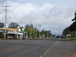
Malanda is a rural town and locality in the Tablelands Region, Queensland, Australia. In the 2016 census, Malanda had a population of 1,985 people. The economy is based upon agriculture and tourism.

Millaa Millaa, Queensland Town in Queensland, Australia

Millaa Millaa is a rural town and locality in the Tablelands Region, Queensland, Australia. In the 2016 census, Millaa Millaa had a population of 514 people.

Millaa Millaa Falls Waterfall in Far North Queensland, Australia

Millaa Millaa Falls is a heritage-listed plunge waterfall at Theresa Creek Road, Millaa Millaa, Tablelands Region, Queensland, Australia. It was added to the Queensland Heritage Register on 5 December 2005.

Shire of Eacham Local government area in Queensland, Australia

The Shire of Eacham was a local government area of Queensland. It was located on the Atherton Tableland, a plateau forming part of the Great Dividing Range west of the city of Cairns. The shire, administered from the town of Malanda, covered an area of 1,126.4 square kilometres (434.9 sq mi), and existed as a local government entity from 1910 until 2008, when it amalgamated with several other councils in the Tableland area to become the Tablelands Region.

Tablelands Region Local government area in Queensland, Australia

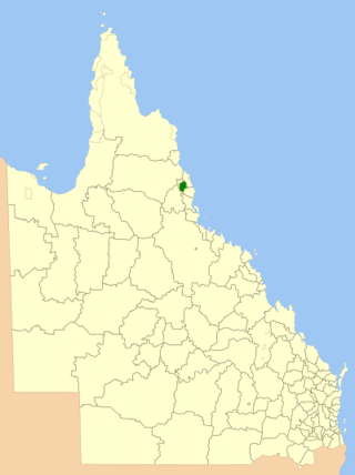
The Tablelands Region is a local government area in Far North Queensland, Australia inland from the city of Cairns. Established in 2008, it was preceded by four previous local government areas which dated back more than a century. On 1 January 2014, one of those local government areas, the Shire of Mareeba, was re-established independent of the Tablelands Region.

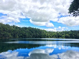
Lake Eacham is a rural locality in the Tablelands Region, Queensland, Australia. In the 2016 census, Lake Eacham had a population of 457 people.

Koumala is a rural town and coastal locality in the Mackay Region, Queensland, Australia. In the 2016 census, the locality of Koumala had a population of 831 people.

Tablelands railway line, Queensland

The Tablelands railway line is a railway line in North Queensland, Australia. It was opened in a series of sections between 1887 and 1916. It commences at Cairns and at its maximum extent, reached Ravenshoe at the southern end of the Atherton Tableland. The rail system served by this line was unusual for Queensland in that the majority of lines that connected to it were built by private companies and later purchased by the Queensland Government.

Malanda Falls Swimming Pool Historic site in Queensland, Australia

Malanda Falls Swimming Pool is a heritage-listed swimming pool at Malanda Falls Park, Malanda, Tablelands Region, Queensland, Australia. It was built from 1906 onwards. It was added to the Queensland Heritage Register on 5 February 2010.

Lake Eacham Hotel Historic site in Queensland, Australia

Lake Eacham Hotel is a heritage-listed hotel at 6-8 Kehoe Place, Yungaburra, Tablelands Region, Queensland, Australia. It was built in 1910 by Side Brothers. It was added to the Queensland Heritage Register on 21 October 1992.

Yungaburra Court House Historic site in Queensland, Australia

Yungaburra Court House is a heritage-listed courthouse at 6 - 10 Cedar Street, Yungaburra, Tablelands Region, Queensland, Australia. It was built from 1909 to 1921. It is also known as Court of Petty Sessions. It was added to the Queensland Heritage Register on 21 October 1992.

Ellinjaa is a rural locality in the Tablelands Region, Queensland, Australia. In the 2016 census, Ellinjaa had a population of 31 people.

Kureen is a rural locality in the Tablelands Region, Queensland, Australia. In the 2016 census Kureen had a population of 122 people.

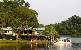
Lake Barrine is a rural locality in the Tablelands Region, Queensland, Australia. In the 2016 census, Lake Barrine had a population of 152 people.

Minbun is a rural locality in the Tablelands Region, Queensland, Australia. In the 2016 census Minbun had a population of 75 people.

References

  1. 1 2 3 Australian Bureau of Statistics (27 June 2017). "Peeramon (SSC)". 2016 Census QuickStats. Retrieved 20 October 2018. OOjs UI icon edit-ltr-progressive.svg
  2. 1 2 "Peeramon – town in Tablelands Region (entry 26298)". Queensland Place Names. Queensland Government . Retrieved 29 December 2020.
  3. "Peeramon – locality in Tablelands Region (entry 48834)". Queensland Place Names. Queensland Government . Retrieved 29 December 2020.
  4. 1 2 "Queensland Globe". State of Queensland . Retrieved 12 July 2022.
  5. "Chumbrumba – locality unbounded in Tablelands Regional (entry 39243)". Queensland Place Names. Queensland Government . Retrieved 7 March 2022.
  6. "Weerimba – locality unbounded in Tablelands Regional (entry 39345)". Queensland Place Names. Queensland Government . Retrieved 7 March 2022.
  7. "Tula – locality unbounded in Tablelands Regional (entry 39331)". Queensland Place Names. Queensland Government . Retrieved 7 March 2022.
  8. "Mountain peaks and capes - Queensland". Queensland Open Data. Queensland Government. 12 November 2020. Archived from the original on 25 November 2020. Retrieved 25 November 2020.
  9. "Mount Quincan – mountain in Tablelands Region (entry 27831)". Queensland Place Names. Queensland Government . Retrieved 25 November 2020.
  10. "LAKE EACHAM SCHOOL". The Telegraph . No. 11841. Queensland, Australia. 29 October 1910. p. 2 (SECOND EDITION). Archived from the original on 12 July 2022. Retrieved 12 July 2022 via National Library of Australia.
  11. "WORKS TENDERS". Cairns Post . Vol. XXIV, no. 820. Queensland, Australia. 21 September 1910. p. 4. Archived from the original on 12 July 2022. Retrieved 12 July 2022 via National Library of Australia.
  12. "NEW PUBLIC WORKS". Daily Standard . No. 1402. Queensland, Australia. 8 June 1917. p. 5 (SECOND EDITION). Archived from the original on 12 July 2022. Retrieved 12 July 2022 via National Library of Australia.
  13. Queensland Family History Society (2010), Queensland schools past and present (Version 1.01 ed.), Queensland Family History Society, ISBN   978-1-921171-26-0
  14. "Bartle Frere" (Map). Queensland Government. 1949. Retrieved 12 July 2022.
  15. "Queensland Two Mile series sheet 2m404" (Map). Queensland Government. 1943. Archived from the original on 14 January 2021. Retrieved 12 July 2022.
  16. "Opening of the Methodist Church at Peeramon". The Northern Herald . Vol. XXII, no. 279. Queensland, Australia. 8 August 1918. p. 49. Archived from the original on 12 July 2022. Retrieved 12 July 2022 via National Library of Australia.

Further reading