
The Russell Company Upper Mill is an historic structure in Middletown, Connecticut, built in 1836 and listed on the National Register of Historic Places. The building stands at the junction of Russell Street and East Main Street in South Farms. There is a small pond to the south. East Main Street's commercial and industrial development ends there. To the north, small businesses border the street, followed by the buildings of Russell Manufacturing Company, the area's most dominant feature. Russell Street crosses Sumner Brook nearby and ascends to a large residential district to the west. The mill is currently a condo-apartment complex.

The Main Street Historic District encompasses the historic commercial center of Middletown, Connecticut, United States. Middletown was one of the most important ports on the Connecticut River during the colonial period, and Main Street "has been the center of community life since the earliest period of settlement". Today Main Street is home to a number of 19th century buildings, maintaining the bulk of its historic character. It was listed on the National Register of Historic Places in 1983.
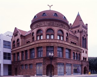
The Barnum Museum is a museum at 820 Main Street in Bridgeport, Connecticut, United States. It has an extensive collection related to P. T. Barnum and the history of Bridgeport, and is housed in a historic building on the National Register of Historic Places.

The Main Street Historic District in Danbury, Connecticut, United States, is the oldest section of that city, at its geographical center. It has long been the city's commercial core and downtown. Its 132 buildings, 97 of which are considered contributing properties, include government buildings, churches, commercial establishments and residences, all in a variety of architectural styles from the late 18th century to the early 20th. It is the only major industrial downtown of its size in Connecticut not to have developed around either port facilities or a water power site.

Wyoming is a village and census-designated place on the Wood River in southern Rhode Island, primarily in the town of Richmond, Rhode Island, but extending north across the river into the town of Hopkinton, Rhode Island. The population was 270 at the 2010 census. It is the site of the Wyoming Village Historic District and a post office assigned ZIP code 02898.
The Lower Lisbon Street Historic District encompasses part of the earliest commercial center of Lewiston, Maine. Located on the west side of Lisbon Street, the city's main commercial area, between Cedar and Chestnut Streets are a collection of commercial buildings representing a cross section of architectural styles, built between 1850 and 1950. When the historic district was listed on the National Register of Historic Places in 1985, it included 18 buildings. Eleven of these have since been demolished, and one has a significantly altered facade.

The Southport Historic District in the town of Fairfield, Connecticut is a 225-acre (91 ha) area historic district that was listed on the National Register of Historic Places in 1971. It preserves a portion of the modern neighborhood and former borough of Southport, Connecticut. Since the British burnt almost all of Southport's structures in 1779, there is only one home built prior to that date, the Meeker House at 824 Harbor Road, which survives.

Bridgeport is a historic seaport city in the U.S. state of Connecticut, and its largest city. With a census-estimated population of 144,399 in 2019, it is also the fifth-most populous in New England. Located in Fairfield County at the mouth of the Pequonnock River on Long Island Sound, it is 60 miles (97 km) from Manhattan and 40 miles (64 km) from The Bronx. It is bordered by the towns of Trumbull to the north, Fairfield to the west, and Stratford to the east. Bridgeport and other settlements in Fairfield County make up the Bridgeport-Stamford-Norwalk-Danbury metropolitan statistical area, the second largest metropolitan area in Connecticut. The Bridgeport-Stamford-Norwalk-Danbury metropolis forms part of the New York megacity.

Bassickville Historic District is a historic district encompassing a well-preserved late 19th-century residential development on the west side of Bridgeport, Connecticut. Located on Bassick, Howard, and Fairview Avenues, the area was developed as a residential subdivision of worker housing by Edmund Bassick. The development is characterized by nearly identical 1-1/2 story frame cottages exhibiting the Stick style of architecture. The district was listed on the National Register of Historic Places in 1987.
The Upper State Street Historic District encompasses a well-preserved neighborhood commercial district of the late 19th century in the East Rock neighborhood of New Haven, Connecticut. The district is an irregular strip running NNE to SSW mainly along State Street in New Haven, one block west of Interstate 91, the highway which determines the district's eastern and southern borders. The district was listed on the U.S. National Register of Historic Places in 1984.

The Bridgeport Downtown South Historic District encompasses the historic elements of the southern part of downtown Bridgeport, Connecticut. It is 27 acres (11 ha) in size, roughly bordered on the east by Main and Middle Streets, on the north by Elm Street, the west by Broad Street, and the south by Cesar Batalla Way. This area includes the highest concentration of buildings developed in the commercial downtown between about 1840 and the 1930s, the period of the city's major growth as a manufacturing center, and includes a diversity of architectural styles representative of that time period. The district was listed on the National Register of Historic Places in 1987.
Palliser, Palliser & Company was a Bridgeport, Connecticut, and New York City architectural firm and publisher of architectural pattern books.

The Barnum–Palliser Historic District is a 5.9-acre (2.4 ha) residential historic district in Bridgeport, Connecticut. The area, bounded roughly by Austin Street, Myrtle Avenue, Atlantic Street, and Park Avenue, was developed by P.T. Barnum to provide worker housing in the 1880s. Many of the houses were designed by Palliser, Palliser & Co., and are interesting examples of Italianate, Queen Anne, and Stick/Eastlake architecture. The district was listed on the National Register of Historic Places in 1982.

The Bridgeport Downtown North Historic District encompasses a portion of the commercial downtown of Bridgeport, Connecticut. It isroughly bounded on the north by Congress Street, the east by Water and Middle Streets, the south by Fairfield Avenue, and the west by Lyon Terrace, roughly the northeastern quadrant of the downtown area. It is one of two large clusters of historically significant commercial and civic buildings encapsulating the city's growth as an urban industrial and regional government center. It was listed on the National Register of Historic Places in 1987.

The Depot Square Historic District encompasses the historic commercial business district of Randolph, Vermont. Developed in the mid-19th century around the facilities of the Central Vermont Railway, the area features a high concentration of well-preserved Second Empire and late Victorian commercial architecture. It was listed on the National Register of Historic Places in 1975.

The Walnut Hill District is a historic district encompassing a predominantly residential area southwest of downtown New Britain, Connecticut. Roughly bounded by Walnut Hill Park and the New Britain General Hospital, as well as West Main, Main, Arch, and Hart Streets, the area mirrors in residential architecture the growth of the city as an industrial center between 1840 and 1930. The district was listed on the National Register of Historic Places in 1975.
The Golden Hill Historic District encompasses a well-preserved formerly residential area on the northwest fringe of downtown Bridgeport, Connecticut. Located mainly on Lyon Terrace, Gold Hill Street, and Congress Street, the district includes 11 formerly residential buildings now mainly in commercial use, which were built between about 1890 and 1930. It also includes Bridgeport City Hall, and the Golden Hill United Methodist Church. The district was listed on the National Register of Historic Places in 1987.

The Deacon's Point Historic District encompasses a historic 19th-century residential area of eastern Bridgeport, Connecticut. Roughly bounded by Seaview Avenue and Williston, Bunnell and Deacon Streets, the district was first laid out for development shortly after the American Civil War, and contains modest examples of residential architecture dating from 1866 to the early 20th century. The district was listed on the National Register of Historic Places in 1992.

The Division Street Historic District encompasses one of the best-preserved 19th-century residential areas of Bridgeport, Connecticut. Now separated from downtown Bridgeport by the Connecticut Route 25 highway, the area includes a cross-section of 19th-century architectural styles, as well as a diversity of sophistication, from working-class accommodations to high-style Victorian mansions. The district was listed on the National Register of Historic Places in 1982.

The East Bridgeport Historic District encompasses one of the best-preserved 19th-century neighborhoods of Bridgeport, Connecticut. Bounded by Arctic Street, East Main Street, the railroad tracks, and the Pequonnock River, this area was a planned development of Bridgeport promoter P.T. Barnum and landowner William H. Noble. Its development prompted the significant growth of industry and economic activity east of the Pequonnock River. The district was listed on the National Register of Historic Places in 1979.


