
Kingston is a village and a census-designated place within the town of South Kingstown in Washington County, Rhode Island, United States, and the site of the main campus of the University of Rhode Island. The population was 6,974 at the 2010 census. Much of the village center is listed on the National Register of Historic Places as Kingston Village Historic District. It was originally known as Little Rest.

The Eleazer Arnold House is a historic house built for Eleazer Arnold in about 1693, and located in the Great Road Historic District at Lincoln, Rhode Island. It is now a National Historic Landmark owned by Historic New England, and open to the public on weekends.

The Clemence–Irons House is a historic house located in Johnston, Rhode Island. It was built by Richard Clemence in 1691 and is a rare surviving example of a "stone ender", a building type first developed in the western part of England and common in colonial Rhode Island. The house is listed on the National Register of Historic Places, and is a historic house museum owned and operated by Historic New England. It is open Saturdays between June and mid-October.

The College Hill Historic District is located in the College Hill neighborhood of Providence, Rhode Island, United States. It was designated a National Historic Landmark District on December 30, 1970. The College Hill local historic district, established in 1960, partially overlaps the national landmark district. Properties within the local historic district are regulated by the city's historic district zoning ordinance, and cannot be altered without approval from the Providence Historic District Commission.

The William Whalley Homestead is an historic farmstead in Little Compton, Rhode Island. The main house is a 1+1⁄2-story wood-frame structure, probably built sometime between 1815 and 1830. The property includes a late 19th century gabled barn and a stone and wood outbuilding, and is bounded by a low stone wall. The main house is a fairly typical Cape style house, five bays wide, with a central chimney. The property as a whole is a well-preserved example of a typical 19th-century farmstead in the area.

The Esek Hopkins House is an historic home on 97 Admiral Street on the north side of Providence, Rhode Island, United States.

The Osborn–Bennett Historic District is a residential historic district in Tiverton, Rhode Island consisting of four houses. The district was added to the National Register of Historic Places in 2006.

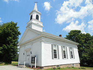
Arnold Mills Historic District is a historic district encompassing a modest 19th-century mill village in eastern Cumberland, Rhode Island. The district lies along the Nate Whipple Highway and Sneech Pond Road, south of the Arnold Mills Reservoir. Sneech Pond Road was formerly the major east-west highway through the area prior to the construction of the Nate Whipple Highway in the 1960s. The Arnold Mills village is in part bisected by Abbott Run, the stream which serves as the outlet of the reservoir; Sneech Pond Road crosses the run on an early 20th-century steel Pratt pony truss, now closed to vehicular traffic. The houses along this road generally date from the late 18th to mid-19th century, and mainly reflect Federal and Greek Revival styling. The most prominent structure in the district is the Arnold Mills United Methodist Church, located at the western end of the district on Nate Whipple Highway; it was built 1825-27 and remodeled in 1846.

The Joy Homestead, also known as the Job Joy House, is an historic house on Old Scituate Avenue in Cranston, Rhode Island. This 2+1⁄2-story gambrel-roof wood-frame house was built sometime between 1764 and 1778. It was occupied by members of the Joy family until 1884, and was acquired by the Cranston Historical Society in 1959. The house is believed to a stopping point on the first day's march in 1781 of the French Army troops en route from Providence to Yorktown during the American Revolutionary War.

The Providence Jewelry Manufacturing Historic District is a predominantly industrial historic district in Providence, Rhode Island. It covers a roughly 19-acre (7.7 ha) area in the city's Jewelry District, just south of Downtown Providence. While the area began as a residential neighborhood, it emerged in the late 19th and early 20th centuries as a center of Providence's jewelry manufacturing businesses. The oldest industrial building in the district is the 1848 Elm Street Machine Shop, a 2+1⁄2-story stone structure that now houses offices of Brown University.
The Lambda Chi Site, designated RI-704, is an historic archaeological site in South Kingstown, Rhode Island. It encompasses the site of an 18th-to-19th century homestead near Kingston village.

The Joseph Slocum House is an historic house on Slocum Road in North Kingstown, Rhode Island. It is a 1+1⁄2-story wood-frame house, five bays wide, with a large central chimney. It faces south on the east side of Slocum Road. The house has been dated to the mid-18th century based on architectural evidence; its first documented owner was Joseph Slocum, in the early 19th century. The house is a rare surviving 18th-century farmhouse, a type once numerous in the town.

Forge Farm is an historic farm in Warwick, Rhode Island. Established in the mid-17th century by the Greene family, it is one of the oldest farms in Rhode Island. It was the birthplace of General Nathanael Greene, a prominent American general in the American Revolutionary War. The core of the main house was built in 1684 by James Greene, son of John Greene, who purchased the land from local Native Americans. It has been extended and altered numerous times in the 18th and 19th centuries. Nathanael Greene was born in this house in 1742, and the farm was owned for many years by Nathanael's brother Christopher, and wife, Deborah (Ward) Greene, daughter of Continental Congress member Samuel Ward.

The Foster–Payne House is a historic house at 25 Belmont Street in Pawtucket, Rhode Island. Built in 1878, the two-story multi-gabled house is distinguished by its clapboarded and exterior woodwork and opulent parlors in the interior. The property also has a matching carriagehouse with gable roof and cupola. The house was originally constructed and owned by Theodore Waters Foster, but it was sold to George W. Payne in 1882. The Foster–Payne House is architecturally significant as a well-designed and well-preserved late 19th century suburban residence. It was added to the National Register of Historic Places in 1983.
The Sterling Hill Historic District encompasses a well-preserved early 19th-century rural village center on western edge of the town of Sterling, Connecticut. Centered at the junction of Plainfield Pike and Sterling Hill Road, it consists of a cluster of 19th and early 19th-century houses, and a church. Unlike other period villages, it has largely been unaffected by later development. It was listed on the National Register of Historic Places in 1986.

Luther's Corner is a historic district encompassing the original economic center of Swansea, Massachusetts. The district is centered on the junction of Old Warren and Pearse Roads, the former being a major stage route between Fall River and Providence, Rhode Island, and was for many years associated with the locally prominent Luther Family. Luther's Corner was added to the National Register of Historic Places in 1990.

The Parker Homestead is a historic home and grounds in Little Silver, Monmouth County, New Jersey, United States, located at 235 Rumson Road near Sickles Park. The main house was originally built circa 1720, and includes materials from an earlier structure the early and late 19th century, and the 1910s and 1920s. It is one of the oldest extant buildings in the state. The farmstead which also includes three outlying barns were listed on the New Jersey Register of Historic Places and the National Register of Historic Places. in 2011.

The Perry Homestead Historic District encompasses a cluster of residences built as a family compound by the locally prominent Perry family in Westerly, Rhode Island. Extending mainly along the northern part of Margin Street south of downtown Westerly, the area was developed in the 1920s, and includes five family residences, a caretaker's house, and shared landscaping of a former gentleman's farm. The district was added to the National Register of Historic Places in 2016.

The Edgewood Historic District–Aberdeen Plat is a residential historic district in the Edgewood neighborhood of eastern Cranston, Rhode Island. Bounded by Berwick Lane and Sefton Drive to the north, Broad Street to the west, Chiswick Road to the south, and the Providence River to the east, this area was developed between 1901 and 1957 as a streetcar suburb for middle and upper middle class residents on what was once a country estate. The district was listed on the National Register of Historic Places in 2016.
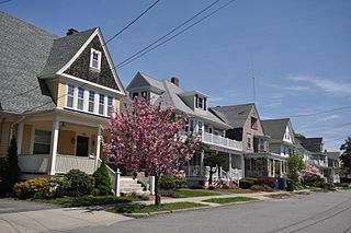
The Edgewood Historic District–Sally Greene Homestead Plats is a residential historic district in the Edgewood neighborhood of eastern Cranston, Rhode Island. Bounded by Glen Avenue to the north, Broad Street to the west, Massasoit Street to the south, and the Providence River to the east, this area was developed between 1900 and 1963 as a streetcar suburb for middle and lower middle class residents on what was once a country estate. The district was listed on the National Register of Historic Places in 2016.


