
Scouting in New Mexico has had a rich and colorful history, from the 1910s to the present day, serving thousands of youth in programs that suit the environment in which they live. The state is home to the Philmont Scout Ranch.

Cortez is a home rule municipality that is the county seat and the most populous municipality of Montezuma County, Colorado, United States. The city population was 8,766 at the 2020 United States Census.

Enchanted Rock is a pink granite mountain located in the Llano Uplift about 17 miles (27 km) north of Fredericksburg, Texas and 24 miles (39 km) south of Llano, Texas, United States. Enchanted Rock State Natural Area, which includes Enchanted Rock and surrounding land, spans the border between Gillespie and Llano counties, south of the Llano River. Enchanted Rock covers roughly 640 acres (260 ha) and rises around 425 feet (130 m) above the surrounding terrain to an elevation of 1,825 feet (556 m) above sea level. It is the largest pink granite monadnock in the United States. Enchanted Rock State Natural Area, a part of the Texas state park system, includes 1,644 acres (665 ha). In 1936, the area was designated a Recorded Texas Historic Landmark. In 1971, Enchanted Rock was designated as a National Natural Landmark by the National Park Service.
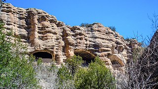
Gila Cliff Dwellings National Monument is a U.S. National Monument created to protect Mogollon cliff dwellings in the Gila Wilderness on the headwaters of the Gila River in southwest New Mexico. The 533-acre (2.16 km2) national monument was established by President Theodore Roosevelt through executive proclamation on November 16, 1907. It is located in the extreme southern portion of Catron County. Visitors can access the monument by traveling northbound from Silver City, New Mexico, 45 miles (72 km) on NM 15.

El Morro National Monument is a U.S. national monument in Cibola County, New Mexico, United States. Located on an ancient east–west trail in the western part of the state, the monument preserves the remains of a large prehistoric pueblo atop a great sandstone promontory with a pool of water at its base, which subsequently became a landmark where over the centuries explorers and travelers have left personal inscriptions that survive today.

Acoma Pueblo is a Native American pueblo approximately 60 miles (97 km) west of Albuquerque, New Mexico, in the United States.

Hubbell Trading Post National Historic Site is a historic site on Highway 191, north of Chambers, with an exhibit center in Ganado, Arizona. It is considered a meeting ground of two cultures between the Navajo and the settlers who came to the area to trade.

This is a list of properties and historic districts in Montana that are listed on the National Register of Historic Places. The state's more than 1,100 listings are distributed across all of its 56 counties.

Mogollon, also called the Mogollon Historic District, is a former mining town located in the Mogollon Mountains in Catron County, New Mexico, United States. Located east of Glenwood and Alma, it was founded in the 1880s at the bottom of Silver Creek Canyon to support the gold and silver mines in the surrounding mountains. The "Little Fannie" mine became the most important employer for the town. During the 1890s, Mogollon had a transient population of between 3,000 and 6,000 miners. Because of its isolation, it had a reputation as one of the wildest mining towns in the West. Today Mogollon is listed as Fannie Hill Mill and Company Town Historic District on the National Register of Historic Places.

Embudo is an unincorporated community in Rio Arriba County, New Mexico, United States. The community runs along both sides of the Rio Grande on New Mexico State Road 68, beginning at Embudo Station located 2.9 miles (4.7 km) south of the intersection of New Mexico State Road 75, near where the Embudo Creek flows into the Rio Grande, encompassing the communities of La Bolsa and Rinconada and ending at the Taos County Line.
Fort Marcy was a military reservation in Santa Fe, New Mexico used during the American Civil War and Mexican–American War. It was decommissioned in the 1890s.

Silver Hill is a neighborhood in southeast Albuquerque, New Mexico, which is significant as one of the oldest developments on the city's East Mesa. Much of the neighborhood is included in the Silver Hill Historic District, which was listed on the National Register of Historic Places in 1986. The neighborhood is roughly bounded by Central Avenue, Yale Boulevard, Central New Mexico Community College, and Presbyterian Hospital. The northeast corner of the neighborhood borders the University of New Mexico campus.

Cherry Spring is an unincorporated farming and ranching community established in 1852 in Gillespie County, in the U.S. state of Texas. It is located on Cherry Spring Creek, which runs from north of Fredericksburg to Llano. The creek was also sometimes known as Cherry Springs Creek by residents. The community is located on the old Pinta Trail. The Cherry Spring School was added to the National Register of Historic Places Listings in Gillespie County, Texas on May 6, 2005. The school was designated a Recorded Texas Historic Landmark in 1985.

Nob Hill is a neighborhood in Albuquerque, New Mexico, United States, consisting of a commercial district along Central Avenue and surrounding residential areas. Located just east of the University of New Mexico, the neighborhood was developed between about 1925 and 1950 and has since become a popular tourist and shopping destination. Known for its eclectic mix of mostly locally owned businesses, Nob Hill has been described as "the heart of Albuquerque's Route 66 culture and also its hippest, funkiest retail and entertainment district". The neighborhood is named after Nob Hill in San Francisco, California.

The Silver City Woman's Club is a historic women's club located at 411 Silver Heights Boulevard in Silver City, New Mexico. The club was founded in 1909, and it built its meeting house in 1935–36. Richard Tatsch designed the clubhouse in the Pueblo Revival style, which reflected the region's architectural history. The clubhouse provided two spaces for the club's community activities and private meetings; the former included distributing food to needy families and conducting child welfare inspections on behalf of the state, while the latter included self-improvement courses in music and literature. The women's club has continuously held its activities in the building since its construction; it has also provided a space for community meetings and large events.
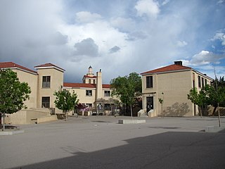
Monte Vista Elementary School is a public elementary school in the Nob Hill neighborhood of Albuquerque, New Mexico, whose campus is listed in the New Mexico State Register of Cultural Properties and the National Register of Historic Places. It is notable as one of the city's best examples of Mediterranean Revival architecture and as the historical focal point of the surrounding neighborhood. It is a part of Albuquerque Public Schools.

Monte Vista Fire Station is a historic former fire station in the Nob Hill neighborhood of Albuquerque, New Mexico. Built in 1936 using Works Progress Administration funding, it is notable as a well-preserved WPA municipal project and for its significance in the early development of the Nob Hill area. The building served in its original role as a fire station until 1972 and currently houses a restaurant. It is the city's third oldest surviving fire station after the AT&SF Fire Station, built in 1920, and the old station #2 on the corner of High St. and Silver Ave. opened in 1926.


