
Waseca County is a county in the U.S. state of Minnesota. As of the 2020 census, the population was 18,968. Its county seat is Waseca.

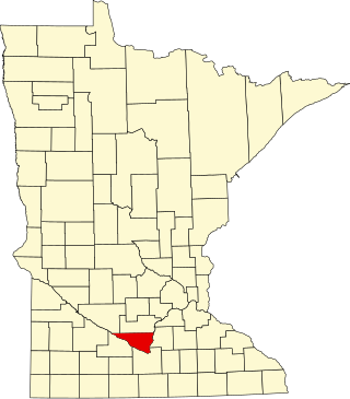
Nicollet County is a county in the U.S. state of Minnesota. As of the 2020 census, the population was 34,454. Its county seat is St. Peter.

St. Peter is a city and the county seat of Nicollet County, Minnesota United States. It is 10 miles north of the Mankato – North Mankato metropolitan area. The population was 12,066 at the 2020 census. It is home to Gustavus Adolphus College.

Nicollet Avenue is a major street in Minneapolis, Richfield, Bloomington, and Burnsville in the U.S. state of Minnesota. It passes through a number of locally well-known neighborhoods and districts, notably Eat Street in south Minneapolis and the traffic-restricted Nicollet Mall in downtown Minneapolis.

Nicollet Island is an island in the Mississippi River just north of Saint Anthony Falls in central Minneapolis, Minnesota. According to the United States Census Bureau the island has a land area of 194,407 square metres (0.075 sq mi) and a 2000 census population of 144 persons. The island makes up a large part of the city-designated Nicollet Island/East Bank neighborhood. The island is named for cartographer Joseph Nicollet, who mapped the Upper Mississippi in the 1830s.

Saint Anthony Main is a stretch of buildings on Main Street across from Saint Anthony Falls in the Marcy-Holmes and Nicollet Island/East Bank neighborhoods of Minneapolis. The area is part of Southeast, Minneapolis, as it was originally the Main Street through the township of St. Anthony, Minnesota prior to most of that township's annexation in 1872. It opened as a festival marketplace in the 1980s.

This is a list of sites in Minnesota which are included in the National Register of Historic Places. There are more than 1,700 properties and historic districts listed on the NRHP; each of Minnesota's 87 counties has at least 2 listings. Twenty-two sites are also National Historic Landmarks.
West Newton is a ghost town in section 30 of West Newton Township in Nicollet County, Minnesota, United States, along the Minnesota River, near New Ulm.

The Eastman tunnel, also called the Hennepin Island tunnel, was a 2,000-foot-long (600 m) underground passage in Saint Anthony, Minnesota, dug beneath the Mississippi River riverbed between 1868 and 1869 to create a tailrace so water-powered business could be located upstream of Saint Anthony Falls on Nicollet Island. The tunnel ran downstream from Nicollet Island, beneath Hennepin Island, and exited below Saint Anthony Falls.

Norseland is an unincorporated community in Lake Prairie Township, Nicollet County, Minnesota, United States, near St. Peter. It is near the junction of State Highway 22 and Nicollet County Road 52.
Dayton's Bluff is a neighborhood located on the east side of the Mississippi River in the southeast part of the city of Saint Paul, Minnesota which has a large residential district on the plateau extending backward from its top. The name of the bluff commemorates Lyman Dayton, for whom a city in Hennepin County was also named. On the edge of the southern and highest part of Dayton's Bluff, in Indian Mounds Park, is a series of seven large aboriginal mounds, 4 to 18 feet high, that overlook the river and the central part of the city.
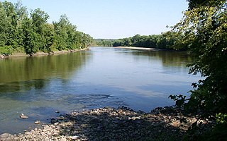
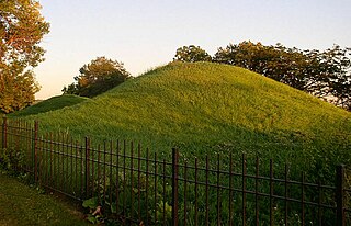
Traverse des Sioux is a historic site in the U.S. state of Minnesota. Once part of a pre-industrial trade route, it is preserved to commemorate that route, a busy river crossing on it, and a nineteenth-century settlement, trading post, and mission at that crossing place. It was a transshipment point for pelts in fur trading days, and the namesake for an important United States treaty that forced the Dakota people to cede part of their homeland and opened up much of southern Minnesota to European-American settlement.

This list is of the properties and historic districts which are designated on the National Register of Historic Places or that were formerly so designated, in Hennepin County, Minnesota; there are 194 entries as of November 2024. A significant number of these properties are a result of the establishment of Fort Snelling, the development of water power at Saint Anthony Falls, and the thriving city of Minneapolis that developed around the falls. Many historic sites outside the Minneapolis city limits are associated with pioneers who established missions, farms, and schools in areas that are now suburbs in that metropolitan area.

The Andrew R. McGill House is a historic house in Saint Paul, Minnesota, United States.

The Vision of Peace is a statue in the three-story memorial concourse lobby along the Fourth Street entrance of the Saint Paul City Hall and Ramsey County Courthouse in Saint Paul, Minnesota, United States. The memorial to the Minnesota 20th-century war dead was created by Swedish sculptor Carl Milles, who named it Indian God of Peace. He drew on memories of a Native American ceremony he witnessed in Ponca City, Oklahoma. Although there is no connection between Native American spirituality and his own vision, Milles depicted five Native Americans seated around a fire holding sacred pipes. Emerging from the smoke of those pipes is a "god of peace" which Milles imagined speaking to "all the world.”
This is a list of the National Register of Historic Places listings in Nicollet County, Minnesota. It is intended to be a complete list of the properties and districts on the National Register of Historic Places in Nicollet County, Minnesota, United States. The locations of National Register properties and districts for which the latitude and longitude coordinates are included below, may be seen in an online map.

This is a list of the National Register of Historic Places listings in Washington County, Minnesota. It is intended to be a complete list of the properties and districts on the National Register of Historic Places in Washington County, Minnesota, United States. The locations of National Register properties and districts for which the latitude and longitude coordinates are included below, may be seen in an online map.
American Indian Rock Art in Minnesota MPS is a Multiple Property Submission (MPS) of the eligibility of many rock art properties for listing on the National Register of Historic Places. The listing is to protect and preserve Native American petroglyphs, pictographs and petroform rock art sites in the present day U.S. state of Minnesota.

Edward Payson Bassford (1837–1912) was an architect who practiced in St. Paul, Minnesota, in the late 19th century. Born in Calais, Maine, on June 7, 1837, he moved to St. Paul in 1866. He worked in the office of Abraham Radcliffe for a time, then founded his own architectural firm. By the 1870s, Bassford was the busiest architect in St. Paul, working on designs for houses, schools, and many commercial buildings. His firm also employed architects who later were famous in their own right, such as Cass Gilbert, Augustus Gauger, Edward J. Donohue, Silas Jacobson, and Charles Bassford. He died in Osakis, Minnesota, on July 20, 1912.

Eugene Saint Julien Cox was an American politician and lawyer.
