
The Great Northern Railway was an American Class I railroad. Running from Saint Paul, Minnesota, to Seattle, Washington, it was the creation of 19th-century railroad entrepreneur James J. Hill and was developed from the Saint Paul & Pacific Railroad. The Great Northern's route was the northernmost transcontinental railroad route in the U.S.

The Yellowstone River is a tributary of the Missouri River, approximately 671 miles (1,080 km) long, in the Western United States. Considered the principal tributary of upper Missouri, via its own tributaries it drains an area with headwaters across the mountains and high plains of southern Montana and northern Wyoming, and stretching east from the Rocky Mountains in the vicinity of Yellowstone National Park. It flows northeast to its confluence with the Missouri River on the North Dakota side of the border, about 25 miles (40 km) west of Williston.
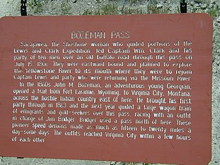
Bozeman Pass el. 5,702 feet (1,738 m) is a mountain pass situated approximately 13 miles (21 km) east of Bozeman, Montana and approximately 15 miles (24 km) west of Livingston, Montana on Interstate 90. It separates the Bridger and Gallatin mountain ranges.

The National Register of Historic Places in the United States is a register including buildings, sites, structures, districts, and objects. The Register automatically includes all National Historic Landmarks as well as all historic areas administered by the U.S. National Park Service. Since its introduction in 1966, more than 97,000 separate listings have been added to the register.
Big Rivers Regional Trail is a paved 4.5-mile (7.2 km) rail trail that overlooks the confluence of the Minnesota and Mississippi rivers along the northern edge of Dakota County, Minnesota, United States. It runs between the cities of Eagan and Lilydale.

Interstate 94 (I-94) runs east–west for 352.4 miles (567.1 km) through the southern half of the US state of North Dakota, from the Montana state line east to the Red River at Fargo. The route generally follows the route of the Northern Pacific Railway.

The Northern Transcon, a route operated by the BNSF Railway, traverses the most northerly route of any railroad in the western United States. This route was originally part of the Chicago, Burlington and Quincy Railroad, Northern Pacific Railway, Great Northern Railway and Spokane, Portland and Seattle Railway systems, merged into the Burlington Northern Railroad system in 1970.

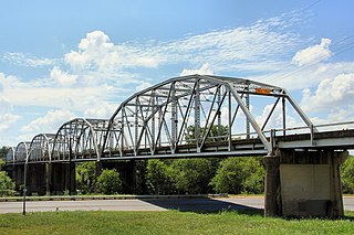
Originally called the High Bridge, the Hi-Line Bridge is a historic railroad bridge located over the Sheyenne River in Valley City, North Dakota. The bridge is 3,860 feet (1,180 m) long and 162 feet (49 m) above the river. Construction work began on July 5, 1906, and it was ready for service on May 8, 1908. At the time it was the longest bridge for its height in the world. It currently remains one of the longest and highest single track railroad viaducts in the United States, and was designated as a National Historic Civil Engineering Landmark by the American Society of Civil Engineers in 2005.

The King Iron Bridge & Manufacturing Company was a late-19th-century bridge building company located in Cleveland, Ohio. It was founded by Zenas King (1818–1892) in 1858 and subsequently managed by his sons, James A. King and Harry W. King and then his grandson, Norman C. King, until the mid-1920s. Many of the bridges built by the company were used during America's expansion west in the late 19th century and early 20th century, and some of these bridges are still standing today.
The Chicago, Milwaukee, St. Paul and Pacific Railroad Company Historic District consists of the historic right-of-way of the Chicago, Milwaukee, St. Paul and Pacific Railroad in the Bitterroot Mountains from East Portal, Montana, to the mouth of Loop Creek, Idaho, a distance of 14.5 miles (23.3 km). The district was once part of the railroad's mainline from Chicago, Illinois to Tacoma, Washington.
The Blackledge River Railroad Bridge is a Warren truss bridge that was built on the site of a c. 1870 railroad bridge. The original bridge was completed and opened by August 3, 1877. Likely built by the Colchester Railway Company, the bridge was part of the 3.59 miles (5.78 km) of track from Colchester, Connecticut, to Turnerville. The line was leased to the Boston and New York Air-Line Railroad and reported improvement in 1879 and a new 110-foot long (34 m) iron bridge by 1881. The line was leased to the New York, New Haven and Hartford Railroad in 1882. After dominating the region, the New York, New Haven and Hartford Railroad petitioned for changes to the Air Line and the approval came on July 7, 1911.

The Burlington, Cedar Rapids and Northern Railway (BCR&N) was a railroad that operated in the United States from 1876 to 1903. It was formed to take over the operations of the bankrupt Burlington, Cedar Rapids and Minnesota Railway, which was, in turn, the result of merging several predecessor lines, the construction of which began in 1869. The corporate headquarters were in Cedar Rapids, Iowa, and it had operations in Iowa and in Minnesota. It was succeeded by the Chicago, Rock Island and Pacific Railway.

Snowden Bridge is a high-clearance, vertical-lift railroad bridge, built in 1913, that spans the Missouri River between Roosevelt and Richland Counties in Montana, USA, between Bainville and Fairview, Montana, and near Fort Union Trading Post National Historic Site and the ghost town of Mondak near Montana's eastern border with North Dakota. Snowden Bridge is a near twin of the Fairview Bridge, which crosses the Yellowstone River in North Dakota, both bridges having been built by Montana Eastern Railway within 10 miles (16 km) of each other over different rivers in different states.
The Dakota Rail Trail runs 28.1 miles (42.6 km) from Wayzata to Lester Prairie, Minnesota. It is on part of the former track bed of the Hutchinson Spur of the Great Northern Railway. The railway line helped bring wheat and raw materials from Central Minnesota to the flour mills, factories and warehouses in Minneapolis from 1885 until 2001. The railway line, from which there are views of the countryside, was also designed to bring tourists to the communities on Lake Minnetonka in the late 1880s.
The Montopolis Bridge is a historic Parker through truss bridge in Austin, Texas. It is located in the Montopolis neighborhood where a bicycle and pedestrian walkway crosses the Colorado River in southeastern Travis County. The bridge consists of five 200-foot Parker through truss spans and four 52-foot steel I-beam approach spans resting on reinforced concrete abutments. It was added to the National Register of Historic Places on October 10, 1996. The Montopolis Bridge sits at the best crossing of the Colorado River in the area with the historic crossing of the El Camino Real de los Tejas National Historic Trail just to the east.

The Camp Clarke Bridge Site in Morrill County, Nebraska, near Bridgeport dates from 1875. Also known as 25 MO 68, it was listed on the National Register of Historic Places in 1974.
The South Dakota Dept. of Transportation Bridge No. 48-244-204 is a bridge over the Little White River just west of White River, South Dakota. At 314 feet (96 m) in length, it is the longest concrete slab bridge in the state. Built in 1934 to carry South Dakota Highway 44 across the river, it now carries a local road north of that road's current alignment.
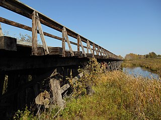
The Minnesota and International Railway Trestle at Blackduck in Beltrami County, Minnesota was the longest timber trestle in the state. It was built in 1901 and 1902 by the Minnesota and International Railway, a subsidiary of the Northern Pacific Railroad, on a line between Koochiching and Bemidji, Minnesota, where it met a branch line of the parent railroad running north from Brainerd. The bridge carried the railroad over Coburn Creek and a difficult marsh in Blackduck and was noted for its considerable length and intact substructure when it was added to the National Register of Historic Places 2014.

South Dakota Department of Transportation Bridge No. 63-210-282 was a historic bridge in rural Turner County, South Dakota, carrying 461st Avenue across the East Fork Vermillion River southwest of Centerville. Built in 1909, it was a well-preserved example of bridges built for the county by the Iowa Bridge Company. It was listed on the National Register of Historic Places in 1999. The bridge's original Pratt through main span was replaced by a steel girder span in 2009–10.


