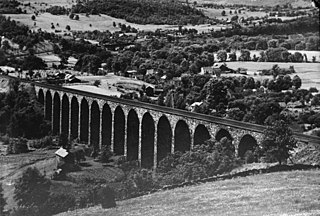
Starrucca Viaduct is a stone arch bridge that spans Starrucca Creek near Lanesboro, Pennsylvania, in the United States. Completed in 1848 at a cost of $320,000, it was at the time the world's largest stone railway viaduct and was thought to be the most expensive railway bridge as well. Still in use, the viaduct is listed on the National Register of Historic Places and is designated as a National Historic Civil Engineering Landmark.
The Elm Grove Stone Arch Bridge, also known as the Monument Place Bridge, is the oldest extant bridge, built in 1817, in the U.S. state of West Virginia. The bridge carries U.S. Route 40 over Little Wheeling Creek in Elm Grove. The bridge was placed on the National Register of Historic Places on August 21, 1981.
Plunketts Creek Bridge No. 3 was a rubble masonry stone arch bridge over Plunketts Creek in Plunketts Creek Township, Lycoming County in the U.S. state of Pennsylvania. It was built between 1840 and 1875, probably closer to 1840, when the road along the creek between the unincorporated villages of Barbours and Proctor was constructed. Going upstream from the mouth, the bridge was the third to cross the creek, hence its name.

The US 41–Fanny Hooe Creek Bridge is a highway bridge located on US Highway 41 (US 41) over the Fanny Hooe Creek about one mile east of Copper Harbor, adjacent to Fort Wilkins State Park, in Grant Township, Michigan. It was listed on the National Register of Historic Places in 1999.

The County Farm Bridge is a historic stone arch bridge in Wilton, New Hampshire. Built in 1885, it carries Old County Farm over Whiting Brook, just south of its northern junction with Burton Highway in a rural section of northwestern Wilton. It is an unusually late and well-preserved example of a 19th-century stone arch bridge, and was listed on the National Register of Historic Places in 1981.

The Cedar Swamp Covered Bridge, also known as the Station Bridge and by various other names, was a historic wooden covered bridge spanning Otter Creek between Cornwall and Salisbury, Vermont. The Town lattice truss bridge was built in 1864-1865 and added to the National Register of Historic Places in 1974. It was destroyed by fire in September 2016.
Lalino Stone Arch Bridge is a historic stone arch bridge located near Middleville in Herkimer County, New York. It was constructed in 1870 and spans Perkosky brook a tributary of Maltanner Creek, which empties into West Canada Creek. It is 35 feet long and has a single arch with a span of 23 feet and rise of eight feet, six inches.

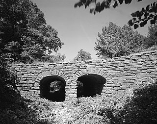
Old City Road Stone Arch Bridge is a historic stone arch bridge located near Welch Corners in Herkimer County, New York. It was constructed in 1898 and spans City Brook, a tributary of West Canada Creek. It is 64 feet long and has a double arch with spans of 28 feet and rise of 12 feet.

Route 29 Stone Arch Bridge is a historic stone arch bridge located near Middleville in Herkimer County, New York. It was constructed in 1870 and spans the south branch of Maltanner Creek, which empties into West Canada Creek. It is situated on the north side of present New York State Route 29. It is 35 feet long and has a single arch with a span of 20 feet and rise of 12 feet.

The Pithole Stone Arch Bridge is a 37-foot (11 m) masonry, deck arch bridge that spans Pithole Creek between Cornplanter and President Townships, Venango County in the U.S. state of Pennsylvania. The bridge was listed on the National Register of Historic Places in 1988 and was documented by the Historic American Engineering Record (HAER) in 1997.

Quinlan's Covered Bridge, also called the Quinlan Covered Bridge, or colloquially known as the Lower Covered Bridge, and Sherman Covered Bridge is a wooden covered bridge that crosses Lewis Creek in Charlotte, Vermont on Monkton Road. It was listed on the National Register of Historic Places in 1974. It is one of nine 19th-century Burr arch covered bridges in the state.

Van Metre Ford Stone Bridge is a historic stone arch bridge located near Martinsburg, Berkeley County, West Virginia. Built by Pennsylvania builder Silas Harry, it was built in 1832, and is a three span bridge crossing Opequon Creek. It is 132 feet long and constructed of ashlar limestone. The center span measures 32 feet and the two side spans are each 29.5 feet long.

The Yosemite Valley Bridges are eight bridges in the Yosemite Valley of Yosemite National Park, most of them spanning the Merced River. Five of them were built in 1928, with the remainder built between 1921 and 1933. The bridges feature a concrete structure faced with local stone, in an elliptical or three-centred arch configuration. They are notable for their uniform character and for their conformance to tenets of the National Park Service rustic style. Design work for the seven newer bridges was by George D. Whittle of the San Francisco District Office of the U.S. Bureau of Public Roads for the National Park Service. Concrete bridges were chosen at the urging of Thomas Chalmers Vint of the Park Service, in lieu of alternative designs for steel truss bridges, or suspension bridges suggested by the park superintendent.
The Seguin Covered Bridge, also called the Upper Covered Bridge and the Sequin Covered Bridge, is a wooden covered bridge that crosses Lewis Creek in Charlotte, Vermont on Roscoe Road. It was built about 1850, and is a distinctive variant of a Burr arch design. It was listed on the National Register of Historic Places in 1974.

Valley Railroad Stone Bridge is a historic stone arch bridge spanning Folly Mills Creek near Jolivue, Augusta County, Virginia. It was built in 1874 by the Valley Railroad, and is a four-span structure with an overall length of 130 feet (40 m) and a width of 15 feet (4.6 m). It is constructed of granite and faced in ashlar and features semi-circular arches set on gently splayed piers. It was acquired by the Virginia Department of Transportation in 1965. It is considered a scenic landmark along Interstate 81.

The Bridge at Falling Creek is a historic stone arch bridge located near Richmond, in Chesterfield County, Virginia. It was built about 1823 of rough-cut, uncoursed granite. It is carried by two semicircular barrel arches with voussoirs of rough-finished granite. Its width including parapets is 24 feet (7.3 m), and its length is 148 feet (45 m). It carried the southbound lanes of U.S. Route 301 until 1977, when it was put out of service. It is accessible from a wayside that includes the Falling Creek UDC Jefferson Davis Highway Marker. The bridge was partially damaged in 2004 but still remains significant. It was listed on the National Register of Historic Places in 1995.
The Mulladay Hollow Bridge is a stone arch bridge in rural Carroll County, Arkansas. It carries County Road 204 across Mulladay Hollow Creek, near the southwestern tip of Lake Leatherwood It has two spans, and is built out of roughly square and semi-coursed fieldstone. The arches are elliptical in shape, 9 feet (2.7 m) in height and 9.5 feet (2.9 m) wide, with nearly-square voussoirs forming the arches. The barrels of the arches are skewed with respect to the spandrels, and the wing walls are slightly curved. The roadway carried by the bridge is 30 feet (9.1 m) wide, and the total length of the structure is 120 feet (37 m). The bridge was built with Works Progress Administration funding as part of the development of Lake Leatherwood as a recreation area.

The Sacketts Brook Stone Arch Bridge, also known locally as the Hi-Lo Biddy Stone Arch Bridge, is a historic bridge just outside the village of Putney, Vermont. It is a stone arch bridge that formerly carried Mill Street across Sacketts Brook, about 0.25 miles (0.40 km) east of United States Route 5. It was built in 1906 by James Otis Follett, an area stonemason, and is one of a few surviving examples of his work. The bridge was listed on the National Register of Historic Places in 1976.
The Chicago, Rock Island and Pacific Railroad Stone Arch Viaduct, also known as the Old Stone Arch, is located northeast of Shelby, Iowa, United States. The span carried the Chicago, Rock Island and Pacific Railroad tracks over Little Silver Creek. It measures 35 feet (11 m) from the water level to the deck, 20 feet (6.1 m) in width, and 30 feet (9.1 m) in length. The bridge has flanking wingwalls that measure 40 feet (12 m) in length. Limestone for the bridge was quarried near Earlham, Iowa and transported by train to the site. It is one of two such bridges known to exist in Shelby County. The Rock Island was the first railroad to enter the county, and continued to operate here into the 1950s. At that time they abandoned the line when the Atlantic cutoff was built providing a more direct route between Atlantic, Iowa and Council Bluffs. While the tracks were removed, the stone arch, the railroad grade, and the right-of-way were left intact. They are now part of the Rock Island Old Stone Arch Nature Trail. The bridge was listed on the National Register of Historic Places in 1998.

The West Sixth Street Bridge is a historic stone arch bridge in downtown Austin, Texas. Built in 1887, the bridge is one of the state's oldest masonry arch bridges. It is located at the site of the first bridge in Austin, carrying Sixth Street across Shoal Creek to link the western and central parts of the old city. The bridge was added to the National Register of Historic Places in 2014.


