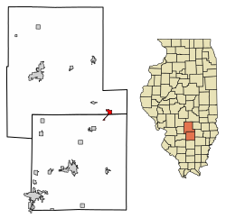
Farina, Illinois

Last updated

Farina, Illinois
Marion County Illinois Incorporated and Unincorporated areas Farina Highlighted.svg
Location in Marion County, Illinois
Usa edcp location map.svg
Red pog.svg
Farina
Location in the United States
Coordinates: 38°49′49″N88°46′47″W / 38.83028°N 88.77972°W / 38.83028; -88.77972 [1]
CountryUnited States
StateIllinois
Counties Fayette, Marion
Townships La Clede, Meacham
Area
[2]
  Total1.46 sq mi (3.79 km2)
  Land1.46 sq mi (3.77 km2)
  Water0.01 sq mi (0.02 km2)
Elevation
[1]
574 ft (175 m)
Population
 (2020) [3]
  Total540
  Density370.62/sq mi (143.09/km2)
Time zone UTC-6 (CST)
  Summer (DST) UTC-5 (CDT)
ZIP code
62838
Area code 618
FIPS code 17-25375
GNIS feature ID2398860 [1]
Wikimedia CommonsFarina, Illinois

Farina is a village in Fayette and Marion counties, Illinois, United States. The population was 540 at the 2020 census. [3] It is the only community with the name "Farina" in the United States. [4]

Contents

History

Farina was founded in 1867. [5] The community was named after farina (food), from its location in the wheat-growing district. [6]

Geography

Farina's limits extend southwest along Illinois Route 37 into Marion County. Interstate 57 passes through the northwest corner of the village at Exit 135, leading northeast 26 miles (42 km) to Effingham and southwest 21 miles (34 km) to Salem. Illinois Route 37 passes through the enter of Farina and runs parallel to I-57. Illinois Route 185 leads northwest 24 miles (39 km) to Vandalia, the Fayette County seat.

According to the 2021 census gazetteer files, Farina has a total area of 1.46 square miles (3.78 km2), of which 1.46 square miles (3.78 km2) (or 99.52%) is land and 0.01 square miles (0.03 km2) (or 0.48%) is water. [7] The village is located at the headwaters of the East Fork of the Kaskaskia River, which drains the village to the southwest.

Demographics

Historical population
CensusPop.Note
1870 232
1880 31837.1%
1890 61894.3%
1900 69312.1%
1910 77411.7%
1920 701−9.4%
1930 694−1.0%
1940 80415.9%
1950 787−2.1%
1960 692−12.1%
1970 634−8.4%
1980 594−6.3%
1990 575−3.2%
2000 558−3.0%
2010 518−7.2%
2020 5404.2%
U.S. Decennial Census [8]

As of the 2020 census [9] there were 540 people, 255 households, and 176 families residing in the village. The population density was 368.85 inhabitants per square mile (142.41/km2). There were 236 housing units at an average density of 161.20 per square mile (62.24/km2). The racial makeup of the village was 95.74% White, 0.00% African American, 0.37% Native American, 0.93% Asian, 0.00% Pacific Islander, 0.19% from other races, and 2.78% from two or more races. Hispanic or Latino of any race were 1.11% of the population.

There were 255 households, out of which 40.8% had children under the age of 18 living with them, 49.80% were married couples living together, 16.08% had a female householder with no husband present, and 30.98% were non-families. 30.98% of all households were made up of individuals, and 15.29% had someone living alone who was 65 years of age or older. The average household size was 3.49 and the average family size was 2.94.

The village's age distribution consisted of 24.6% under the age of 18, 13.6% from 18 to 24, 19.8% from 25 to 44, 18.2% from 45 to 64, and 23.8% who were 65 years of age or older. The median age was 38.2 years. For every 100 females, there were 98.1 males. For every 100 females age 18 and over, there were 101.1 males.

The median income for a household in the village was $35,313, and the median income for a family was $54,464. Males had a median income of $27,381 versus $19,375 for females. The per capita income for the village was $23,298. About 26.7% of families and 20.9% of the population were below the poverty line, including 28.7% of those under age 18 and 17.4% of those age 65 or over.

Related Research Articles

<span class="mw-page-title-main">Mulberry Grove, Illinois</span> Village in Illinois, United States

Mulberry Grove is a village in eastern Bond County, Illinois, United States. The population was 520 at the 2020 census.

<span class="mw-page-title-main">Edgewood, Illinois</span> Village in Illinois, United States

Edgewood is a village in Effingham County, Illinois, United States. The population was 398 at the 2020 Census. Edgewood is part of the Effingham, IL Micropolitan Statistical Area.

<span class="mw-page-title-main">Bingham, Illinois</span> Village in Illinois, United States

Bingham is a village in Fayette County, Illinois, United States. The population was 60 at the 2020 census.

<span class="mw-page-title-main">Brownstown, Illinois</span> Village in Illinois, United States

Brownstown is a village in Fayette County, Illinois, United States. The population was 690 at the 2020 census, down from 759 at the 2010 census.

<span class="mw-page-title-main">Ramsey, Illinois</span> Village in Illinois, United States

Ramsey is a village in Fayette County, Illinois, United States. The population was 911 as of the 2020 census.

<span class="mw-page-title-main">St. Peter, Illinois</span> Village in Illinois, United States

St. Peter or Saint Peter is a village in Fayette County, Illinois, United States. The population was 322 at the 2020 census.

<span class="mw-page-title-main">Liverpool, Illinois</span> Village in Illinois, United States

Liverpool is a village in Fulton County, Illinois, United States. The population was 94 at the 2010 census.

<span class="mw-page-title-main">Lomax, Illinois</span> Village in Illinois, United States

Lomax is a village in Henderson County, Illinois, United States. The population was 454 at the 2010 census, a decline from 477 in 2000. It is part of the Burlington, IA–IL Micropolitan Statistical Area.

<span class="mw-page-title-main">Yale, Illinois</span> Village in Illinois, United States

Yale is a village in Jasper County, Illinois, United States. The population was 86 at the 2010 census.

<span class="mw-page-title-main">Lily Lake, Illinois</span> Village in Illinois, United States

Lily Lake is a village in Kane County, Illinois, United States. The town is 15 miles (24 km) southwest of Elgin and 50 miles (80 km) west of Chicago. The village is in the far western part the Chicago metro area. It was incorporated as a village on November 6, 1990. The population was 1,032 at the 2020 census, up from 993 in 2010.

<span class="mw-page-title-main">Oreana, Illinois</span> Village in Illinois, United States

Oreana is a village in Macon County, Illinois, United States, which had a population of 891 at the 2020 census. It is included in the Decatur, Illinois Metropolitan Statistical Area.

<span class="mw-page-title-main">Alhambra, Illinois</span> Village in Illinois, United States

Alhambra is a village in Madison County, Illinois, United States. The population was 622 at the 2020 census.

<span class="mw-page-title-main">Franklin, Illinois</span> Village in Illinois, United States

Franklin is a village in Morgan County, Illinois, United States. The population was 610 at the 2020 census, unchanged from 2010. It is part of the Jacksonville Micropolitan Statistical Area.

<span class="mw-page-title-main">La Fayette, Illinois</span> Village in Illinois, United States

La Fayette is a village in Stark County, Illinois. It is located south of Kewanee off Route 78 on Route 17|IL-17. The population was 223 at the 2010 census, down from 227 in 2000. It is part of the Peoria, Illinois Metropolitan Statistical Area. Once a prominent strip coal mine and farming village with; a general store, high school(until 1970), hotel, bank, grain elevator, train depot, and many other features and amenities. Once the coal mines shut down and railroad was removed in the early 1980s, it slowly became a low income and high poverty village with many people moving away and it eventually diminished to the hollow shell of what it once was.

<span class="mw-page-title-main">Alto Pass, Illinois</span> Village in Illinois, United States

Alto Pass is a village in Union County, Illinois, United States. The population was 342 at the 2020 census, a decrease from 391 in 2010. The Bald Knob Cross and Bald Knob Wilderness are nearby. Alto Pass lies roughly 5.1 miles to the northwest of downtown Cobden, Illinois. Illinois Route 127 runs just west of the village's downtown area.

<span class="mw-page-title-main">Bush, Illinois</span> Village in Illinois, United States

Bush is a village in Williamson County, Illinois, United States. As of the 2000 census, the village population was 257.

<span class="mw-page-title-main">Bloomingburg, Ohio</span> Village in Ohio, United States

Bloomingburg is a village in Fayette County, Ohio, United States. The population was 878 at the 2020 census.

<span class="mw-page-title-main">Bear Grove Township, Fayette County, Illinois</span> Township in Illinois, United States

Bear Grove Township is one of twenty townships in Fayette County, Illinois, USA. As of the 2020 census, its population was 553 and it contained 232 housing units. The township was originally known as Johnson Township.

<span class="mw-page-title-main">LaClede Township, Fayette County, Illinois</span> Township in Illinois, United States

LaClede Township is one of twenty townships in Fayette County, Illinois, USA. As of the 2020 census, its population was 844 and it contained 374 housing units.

<span class="mw-page-title-main">South Hurricane Township, Fayette County, Illinois</span> Township in Illinois, United States

South Hurricane Township is one of twenty townships in Fayette County, Illinois, USA. As of the 2020 census, its population was 220 and it contained 100 housing units. This township split from Hurricane Township sometime after 1921.

References

  1. 1 2 3 U.S. Geological Survey Geographic Names Information System: Farina, Illinois
  2. "2022 U.S. Gazetteer Files: Illinois". United States Census Bureau. Retrieved February 24, 2023.
  3. 1 2 "P1. Race – Farina village, Illinois: 2020 DEC Redistricting Data (PL 94-171)". U.S. Census Bureau. Retrieved February 24, 2023.
  4. "Search Domestic Names: Farina". Geographic Names Information System. U.S. Board on Geographic Names. Retrieved February 24, 2023.
  5. Illinois Central Magazine. Illinois Central Railroad Company. 1922. p. 46.
  6. Gannett, Henry (1905). The Origin of Certain Place Names in the United States. Govt. Print. Off. pp.  124.
  7. Bureau, US Census. "Gazetteer Files". Census.gov. Retrieved June 29, 2022.
  8. "Census of Population and Housing". Census.gov. Retrieved June 4, 2015.
  9. "Explore Census Data". data.census.gov. Retrieved June 28, 2022.