Farragut, Iowa

Last updated

Farragut, Iowa
Farragut, IA.jpg
Fremont County Iowa Incorporated and Unincorporated areas Farragut Highlighted.svg
Location of Farragut, Iowa
Coordinates: 40°43′12″N95°28′51″W / 40.72000°N 95.48083°W / 40.72000; -95.48083
Country Flag of the United States.svg  United States
State Flag of Iowa.svg  Iowa
County Fremont
Area
[1]
  Total0.40 sq mi (1.04 km2)
  Land0.40 sq mi (1.04 km2)
  Water0.00 sq mi (0.00 km2)
Elevation
[2]
961 ft (293 m)
Population
 (2020)
  Total490
  Density1,221.95/sq mi (471.76/km2)
Time zone UTC-6 (Central (CST))
  Summer (DST) UTC-5 (CDT)
ZIP code
51639
Area code 712
FIPS code 19-26985
GNIS feature ID2394751 [2]

Farragut is a city in Fremont County, Iowa, United States. The population was 490 at the time of the 2020 census. [3]

Contents

History

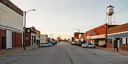
Farragut had its start in the year 1870 by the building of the Burlington & Missouri River Railroad through that territory. [4] It is named for Admiral David Farragut. [5]

Geography

Farragut is located near the East Nishnabotna River.

According to the United States Census Bureau, the city has a total area of 0.41 square miles (1.06 km2), all of it land. [6]

Demographics

Historical populations
YearPop.±%
1880 380    
1890 406+6.8%
1900 514+26.6%
1910 431−16.1%
1920 494+14.6%
1930 523+5.9%
1940 496−5.2%
1950 495−0.2%
1960 495+0.0%
1970 521+5.3%
1980 603+15.7%
1990 498−17.4%
2000 509+2.2%
2010 485−4.7%
2020 490+1.0%
Source: "U.S. Census website". United States Census Bureau . Retrieved March 28, 2020. and Iowa Data Center
Source:
U.S. Decennial Census [7] [3]
The population of Farragut, Iowa from US census data FarragutIowaPopPlot.png
The population of Farragut, Iowa from US census data

2010 census

As of the census [8] of 2010, there were 485 people, 215 households, and 137 families residing in the city. The population density was 1,182.9 inhabitants per square mile (456.7/km2). There were 229 housing units at an average density of 558.5 per square mile (215.6/km2). The racial makeup of the city was 99.6% White, 0.2% Native American, and 0.2% from two or more races. Hispanic or Latino of any race were 2.3% of the population.

There were 215 households, of which 29.8% had children under the age of 18 living with them, 53.0% were married couples living together, 7.4% had a female householder with no husband present, 3.3% had a male householder with no wife present, and 36.3% were non-families. 34.4% of all households were made up of individuals, and 19.1% had someone living alone who was 65 years of age or older. The average household size was 2.26 and the average family size was 2.89.

The median age in the city was 46 years. 22.9% of residents were under the age of 18; 6.4% were between the ages of 18 and 24; 18.4% were from 25 to 44; 31.4% were from 45 to 64; and 21% were 65 years of age or older. The gender makeup of the city was 43.1% male and 56.9% female.

2000 census

As of the census [9] of 2000, there were 509 people, 221 households, and 144 families residing in the city. The population density was 1,390.2 inhabitants per square mile (536.8/km2). There were 234 housing units at an average density of 639.1 per square mile (246.8/km2). The racial makeup of the city was 97.64% White, 0.39% Asian, 0.98% from other races, and 0.98% from two or more races. Hispanic or Latino of any race were 1.57% of the population.

There were 221 households, out of which 27.6% had children under the age of 18 living with them, 55.7% were married couples living together, 7.2% had a female householder with no husband present, and 34.8% were non-families. 32.1% of all households were made up of individuals, and 22.2% had someone living alone who was 65 years of age or older. The average household size was 2.30 and the average family size was 2.85.

25.9% are under the age of 18, 5.1% from 18 to 24, 23.2% from 25 to 44, 22.0% from 45 to 64, and 23.8% who were 65 years of age or older. The median age was 42 years. For every 100 females, there were 85.1 males. For every 100 females age 18 and over, there were 80.4 males.

The median income for a household in the city was $34,250, and the median income for a family was $47,813. Males had a median income of $31,397 versus $21,000 for females. The per capita income for the city was $16,667. About 3.9% of families and 7.5% of the population were below the poverty line, including none of those under age 18 and 10.9% of those age 65 or over.

Education

It is within the Shenandoah Community School District. [10]

It was served by the Farragut Community School District until it closed in 2016. [11] From about 2010 until 2016 Farragut was in a grade-sharing relationship with the Hamburg Community School District; prior to 2015 Farragut students had to go to Hamburg for middle school, while after 2015 all elementary school students went to Hamburg. [12] Nishnabotna High School in Farragut became the community high school for both Farragut and Hamburg. [13]

Transportation

While there is no fixed-route transit service in Farragut, intercity bus service is provided by Jefferson Lines in nearby Shenandoah. [14]

Related Research Articles

<span class="mw-page-title-main">Manilla, Iowa</span> City in Iowa, United States

Manilla is a city in Crawford County, Iowa, United States, along the West Branch of the West Nishnabotna River. The population was 775 at the time of the 2020 census.

<span class="mw-page-title-main">Fremont County, Iowa</span> County in Iowa, United States

Fremont County is a county located in the U.S. state of Iowa. As of the 2020 census the population was 6,605, making it the state's seventh-least populous county. The county seat is Sidney. The county was formed in 1847 and named for the military officer John C. Fremont.

<span class="mw-page-title-main">Brayton, Iowa</span> City in Iowa, United States

Brayton is a city in Audubon County, Iowa, United States, along the East Nishnabotna River. The population was 143 at the 2020 census.

<span class="mw-page-title-main">Exira, Iowa</span> City in Iowa, United States

Exira is a city in Audubon County, Iowa, United States, along the East Nishnabotna River and U.S. Route 71. The population was 787 at the time of the 2020 census.

<span class="mw-page-title-main">Manning, Iowa</span> City in Iowa, United States

Manning is a city in Carroll County, Iowa, United States, along Iowa Highway 141. The population was 1,455 at the time of the 2020 census. It is named for Orlando Harrison Manning, a Lieutenant Governor of Iowa.

<span class="mw-page-title-main">Lewis, Iowa</span> City in Iowa, United States

Lewis is a city in Cass County, Iowa, United States, along the East Nishnabotna River. The population was 357 at the time of the 2020 census.

<span class="mw-page-title-main">Hamburg, Iowa</span> City in Iowa, United States

Hamburg is a city in Fremont County, Iowa, United States, that is the most southwestern city in Iowa, hugging the borders of Missouri to the south and Nebraska to the west. It is situated between the Nishnabotna and Missouri rivers. The population was 890 at the time of the 2020 census. It derives its name from the German city of Hamburg.

<span class="mw-page-title-main">Imogene, Iowa</span> City in Iowa, United States

Imogene is a city in Fremont County, Iowa, United States. The population was 39 at the time of the 2020 census.

<span class="mw-page-title-main">Randolph, Iowa</span> City in Iowa, United States

Randolph is a city in Fremont County, Iowa, United States. The population was 189 at the time of the 2020 census. It is the birthplace of Virginia Smith, Republican U.S. representative from the 3rd District of Nebraska from 1975 until 1991.

<span class="mw-page-title-main">Riverton, Iowa</span> City in Iowa, United States

Riverton is a city in Fremont County, Iowa, United States, along the East Nishnabotna River. The population was 245 at the time of the 2020 census.

<span class="mw-page-title-main">Elliott, Iowa</span> City in Iowa, United States

Elliott is a city in Montgomery County, Iowa, United States, along the East Nishnabotna River. The population was 338 at the time of the 2020 census.

<span class="mw-page-title-main">Essex, Iowa</span> City in Iowa, United States

Essex is a city in Page County, Iowa, United States. The population was 722 in the 2020 census, a decline from the 884 population in 2000.

<span class="mw-page-title-main">Northboro, Iowa</span> City in Iowa, United States

Northboro is a city in Page County, Iowa, United States. The population was 52 at the time of the 2020 census.

<span class="mw-page-title-main">Carson, Iowa</span> City in Iowa, United States

Carson is a city in Pottawattamie County, Iowa, United States. The population was 766 at the 2020 census. Carson has a number of interesting and historic places.

<span class="mw-page-title-main">Hancock, Iowa</span> City in Iowa, United States

Hancock is a city in Pottawattamie County, Iowa, United States, along the West Nishnabotna River. The population was 200 at the time of the 2020 census.

<span class="mw-page-title-main">Oakland, Iowa</span> City in Iowa, United States

Oakland is a city located along the West Nishnabotna River in Pottawattamie County, Iowa, United States. The population was 1,524 at the time of the 2020 census. Formerly named Big Grove, Oakland is home to Nishna Heritage Museum and a number of historical buildings.

<span class="mw-page-title-main">Defiance, Iowa</span> City in Iowa, United States

Defiance is a city in Shelby County, Iowa, United States, along the West Branch of the West Nishnabotna River. The population was 245 at the time of the 2020 census.

<span class="mw-page-title-main">Irwin, Iowa</span> City in Iowa, United States

Irwin is a city in Shelby County, Iowa, United States, along the West Nishnabotna River. The population was 319 at the time of the 2020 census.

<span class="mw-page-title-main">Shenandoah, Iowa</span> City in Iowa, United States

Shenandoah is a city in Page and Fremont counties in Iowa, United States. The population was 4,925 at the time of the 2020 U.S. Census. Once referred to as the "seed and nursery center of the world," Shenandoah is the home to Earl May Seed Company and the radio station KMA, founded by Earl E. May. The early live radio stations gave many performers their start, including The Everly Brothers and Charlie Haden.

<span class="mw-page-title-main">North English, Iowa</span> City in Iowa, United States

North English is a city located mainly in Iowa county with a small portion in Keokuk county in the U.S. state of Iowa. The population was 1,065 at the time of the 2020 census. It is named for the English River.

References

  1. "2020 U.S. Gazetteer Files". United States Census Bureau. Retrieved March 16, 2022.
  2. 1 2 U.S. Geological Survey Geographic Names Information System: Farragut, Iowa
  3. 1 2 "2020 Census State Redistricting Data". census.gov. United states Census Bureau. Retrieved August 12, 2021.
  4. History of Fremont County, Iowa: Containing a History of the County, Its Cities, Towns, Etc. Iowa Historical Company. 1881. pp.  543.
  5. Gannett, Henry (1905). The Origin of Certain Place Names in the United States. Govt. Print. Off. pp.  124.
  6. "US Gazetteer files 2010". United States Census Bureau. Archived from the original on January 25, 2012. Retrieved May 11, 2012.
  7. "Census of Population and Housing". Census.gov. Retrieved June 4, 2015.
  8. "U.S. Census website". United States Census Bureau . Retrieved May 11, 2012.
  9. "U.S. Census website". United States Census Bureau . Retrieved January 31, 2008.
  10. "Shenandoah Iowa Department of Education School District Boundary Verification 2017 - 2018." Iowa Department of Education. Retrieved on June 18, 2018.
  11. "Farragut Community School District has dissolved". Associated Press at Des Moines Register. July 1, 2016. Retrieved June 18, 2018.
  12. Ryan, Mackenzie (March 26, 2015). "Two districts to close schools to keep accreditation". Des Moines-Register . Retrieved June 18, 2018.
  13. Álvarez, Brenda (April 11, 2017). "How a Community Copes When a School Shuts its Doors". NEA Today, National Education Association . Retrieved June 18, 2018.
  14. "Iowa Bus Stops" . Retrieved September 28, 2023.