Randolph, Iowa

Last updated

Randolph, Iowa
Randolph, IA.jpg
Fremont County Iowa Incorporated and Unincorporated areas Randolph Highlighted.svg
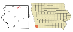
Location of Randolph, Iowa
Coordinates: 40°52′23″N95°33′53″W / 40.87306°N 95.56472°W / 40.87306; -95.56472
Country Flag of the United States.svg  United States
State Flag of Iowa.svg  Iowa
County Fremont
Area
[1]
  Total0.30 sq mi (0.78 km2)
  Land0.30 sq mi (0.78 km2)
  Water0.00 sq mi (0.00 km2)
Elevation
[2]
974 ft (297 m)
Population
 (2020)
  Total189
  Density630.00/sq mi (243.15/km2)
Time zone UTC-6 (Central (CST))
  Summer (DST) UTC-5 (CDT)
ZIP code
51649
Area code 712
FIPS code 19-65640
GNIS feature ID2396317 [2]

Randolph is a city in Fremont County, Iowa, United States. The population was 189 at the time of the 2020 census. [3] It is the birthplace of Virginia Smith, Republican U.S. representative from the 3rd District of Nebraska from 1975 until 1991.

Contents

History

Randolph was platted in 1877, shortly before the completion of the railroad through the territory. [4] The community name was bestowed by agriculturalist Frank Peavy, who named it after Lord Randolph Churchill, father of Winston Churchill. [5]

Geography

Randolph is located at the junction of Deer Creek and the West Nishnabotna River.

According to the United States Census Bureau, the city has a total area of 0.32 square miles (0.83 km2), all land. [6]

Demographics

Historical populations
YearPop.±%
1880 213    
1890 276+29.6%
1900 373+35.1%
1910 304−18.5%
1920 404+32.9%
1930 344−14.9%
1940 379+10.2%
1950 295−22.2%
1960 257−12.9%
1970 214−16.7%
1980 223+4.2%
1990 243+9.0%
2000 209−14.0%
2010 168−19.6%
2020 189+12.5%
Source: "U.S. Census website". United States Census Bureau . Retrieved March 29, 2020. and Iowa Data Center
Source:
U.S. Decennial Census [7] [3]

2010 census

As of the census [8] of 2010, there were 168 people, 72 households, and 50 families residing in the city. The population density was 525.0 inhabitants per square mile (202.7/km2). There were 85 housing units at an average density of 265.6 per square mile (102.5/km2). The racial makeup of the city was 98.2% White, 0.6% African American, and 1.2% from two or more races. Hispanic or Latino of any race were 0.6% of the population.

There were 72 households, of which 30.6% had children under the age of 18 living with them, 58.3% were married couples living together, 5.6% had a female householder with no husband present, 5.6% had a male householder with no wife present, and 30.6% were non-families. 23.6% of all households were made up of individuals, and 5.6% had someone living alone who was 65 years of age or older. The average household size was 2.33 and the average family size was 2.78.

The median age in the city was 47.3 years. 20.2% of residents were under the age of 18; 7.9% were between the ages of 18 and 24; 17.4% were from 25 to 44; 36.8% were from 45 to 64; and 17.9% were 65 years of age or older. The gender makeup of the city was 49.4% male and 50.6% female.

2000 census

As of the census [9] of 2000, there were 209 people, 82 households, and 59 families residing in the city. The population density was 658.7 inhabitants per square mile (254.3/km2). There were 88 housing units at an average density of 277.3 per square mile (107.1/km2). The racial makeup of the city was 99.04% White, and 0.96% from two or more races.

There were 82 households, out of which 34.1% had children under the age of 18 living with them, 58.5% were married couples living together, 11.0% had a female householder with no husband present, and 28.0% were non-families. 23.2% of all households were made up of individuals, and 7.3% had someone living alone who was 65 years of age or older. The average household size was 2.55 and the average family size was 2.97.

28.2% are under the age of 18, 5.7% from 18 to 24, 24.4% from 25 to 44, 28.7% from 45 to 64, and 12.9% who were 65 years of age or older. The median age was 38 years. For every 100 females, there were 88.3 males. For every 100 females age 18 and over, there were 92.3 males.

The median income for a household in the city was $34,861, and the median income for a family was $36,500. Males had a median income of $27,273 versus $20,417 for females. The per capita income for the city was $13,925. About 7.6% of families and 14.3% of the population were below the poverty line, including 17.7% of those under the age of eighteen and 12.5% of those 65 or over.

Education

Fremont–Mills Community School District operates public schools. [10]

Transportation

While there is no fixed-route transit service in Randolph, intercity bus service is provided by Jefferson Lines in nearby Shenandoah. [11]

Notable people

Related Research Articles

<span class="mw-page-title-main">Dodge County, Nebraska</span> County in Nebraska, United States

Dodge County is a county in the U.S. state of Nebraska. As of the 2020 United States Census, the population was 37,167. Its county seat is Fremont. The county was formed in 1855 and named after Iowa Senator Augustus C. Dodge.

<span class="mw-page-title-main">Fremont County, Iowa</span> County in Iowa, United States

Fremont County is a county located in the U.S. state of Iowa. As of the 2020 census the population was 6,605, making it the state's seventh-least populous county. The county seat is Sidney. The county was formed in 1847 and named for the military officer John C. Fremont.

<span class="mw-page-title-main">Fairbank, Iowa</span> City in Iowa, United States

Fairbank is a city in Buchanan and Fayette counties in the U.S. state of Iowa. The population was 1,111 at the time of the 2020 census.

<span class="mw-page-title-main">Maynard, Iowa</span> City in Iowa, United States

Maynard is a city in Fayette County, Iowa, United States. The population was 476 at the time of the 2020 census.

<span class="mw-page-title-main">Farragut, Iowa</span> City in Iowa, United States

Farragut is a city in Fremont County, Iowa, United States. The population was 490 at the time of the 2020 census.

<span class="mw-page-title-main">Imogene, Iowa</span> City in Iowa, United States

Imogene is a city in Fremont County, Iowa, United States. The population was 39 at the time of the 2020 census.

<span class="mw-page-title-main">Riverton, Iowa</span> City in Iowa, United States

Riverton is a city in Fremont County, Iowa, United States, along the East Nishnabotna River. The population was 245 at the time of the 2020 census.

<span class="mw-page-title-main">Sidney, Iowa</span> City in Iowa, United States

Sidney is a city in Fremont County, Iowa, United States. The population was 1,070 at the time of the 2020 census. It is the county seat of Fremont County and is one of the smallest county seats in the state.

<span class="mw-page-title-main">Thurman, Iowa</span> City in Iowa, United States

Thurman is a city in Fremont County, Iowa. As of the 2020 census, the city population was 167.

<span class="mw-page-title-main">Little Sioux, Iowa</span> City in Iowa, United States

Little Sioux is a city in Harrison County, Iowa, United States. The population was 166 at the time of the 2020 census. The city is most known for Little Sioux Scout Ranch of the Boy Scouts of America.

<span class="mw-page-title-main">Modale, Iowa</span> City in Iowa, United States

Modale is a city in Harrison County, Iowa, United States. The population was 273 at the time of the 2020 census.

<span class="mw-page-title-main">Fremont, Iowa</span> City in Iowa, United States

Fremont is a city in Mahaska County, Iowa, United States. The population was 708 at the time of the 2020 census.

<span class="mw-page-title-main">Dixon, Iowa</span> City in Iowa, United States

Dixon is a city in Scott County, Iowa, United States. The population was 202 at the time of the 2020 census.

<span class="mw-page-title-main">Blakesburg, Iowa</span> City in Iowa, United States

Blakesburg is a city in Wapello County, Iowa, United States. The population was 274 at the 2020 census.

<span class="mw-page-title-main">Chillicothe, Iowa</span> City in Iowa, United States

Chillicothe is a city in Wapello County, Iowa, United States. The population was 76 at the 2020 census.

<span class="mw-page-title-main">Kirkville, Iowa</span> City in Iowa, United States

Kirkville is a city in Wapello County, Iowa, United States. The population was 157 at the time of the 2020 census.

<span class="mw-page-title-main">Fremont Hills, Missouri</span> City in Missouri, United States

Fremont Hills is a city in Christian County, Missouri, United States. The population was 1,049 at the 2020 census. It is part of the Springfield, Missouri Metropolitan Statistical Area.

<span class="mw-page-title-main">Randolph, Nebraska</span> City in Nebraska, United States

Randolph is a city in Cedar County, Nebraska, United States. The population was 881 at the 2020 census. It refers to itself as "The Honey Capital of the Nation" due to the per-capita number of bee keeping families.

<span class="mw-page-title-main">Tabor, Iowa</span> City in Iowa, United States

Tabor is a city in Fremont County and extends northward into Mills County in the U.S. state of Iowa. The population was 928 at the time of the 2020 census.

<span class="mw-page-title-main">Randolph, Maine</span> Town in the state of Maine, United States

Randolph is a town and a census-designated place (CDP) in Kennebec County, Maine, United States. The population was 1,743 at the 2020 census. The town was named for Randolph, Massachusetts. Randolph is included in the Augusta, Maine micropolitan New England City and Town Area.

References