
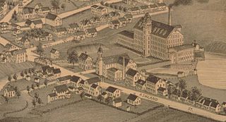
Locke Avenue Bridge is located on Locke Avenue, a two-lane rural route located at the northwest corner of Swedesboro in Gloucester County, New Jersey. This roadway runs generally north-south, connecting Auburn Road with U.S. Route 322. The posted speed limit on Locke Avenue is 40 miles per hour (60 km/h).

Chevelon Creek Bridge is a historic road bridge located about 12 miles (19 km) southeast of Winslow, in Navajo County, eastern Arizona, United States. It is a steel Warren Pony truss bridge over Chevelon Creek, built on the first permanent road connecting Holbrook, the seat of Navajo County, and Winslow. When built, the road was regionally important in northern Arizona as well as being a segment of an early national highway at the time automobile traffic was growing and national roads were first being formed. The bridge was listed on the National Register of Historic Places in 1983 for being a rare design in Arizona, part of an early transnational roadway, one of the first bridges built by Arizona after statehood in 1912, and being in nearly original condition.

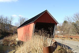
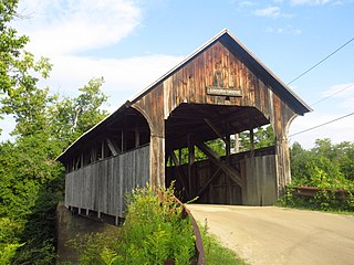
The Church Street Covered Bridge, also called the Village Covered Bridge, is a wooden covered bridge that crosses the North Branch of the Lamoille River in Waterville, Vermont off State Route 109. Built in the late 19th century, it is one of five covered bridges in a space of about five miles that cross the North Branch Lamoille. It was listed on the National Register of Historic Places in 1974.
The Ashland Mill Bridge was a lenticular pony truss bridge over the Pachaug River in Griswold, Connecticut that was built in 1886 by the Berlin Iron Bridge Company. It was built following the Ashland dam break of February 1886 which washed away the previous bridges. The bridge served the millyard of the Ashland Cotton Company, in the Jewett City section of Griswold. The bridge was 65 feet (20 m) long and crossed a millrace on a skew angle. The Ashland Mill was damaged by arson in March 1995 and subsequently torn down, but the bridge itself remained. By 1999, the town deemed the bridge unsafe and closed it, and by February 1999, the bridge was moved to a vacant parking lot and was replaced with a new bridge. The bridge was added to the state of Connecticut historic register and it was later added to the National Register of Historic Places in April 1999. It was removed from the National Register in February 2016.

The Lilley Road—Lower Rouge River Bridge is an automotive bridge located on Lilley Road over the Lower River Rouge in Canton, Michigan. It was listed on the National Register of Historic Places in 2000.

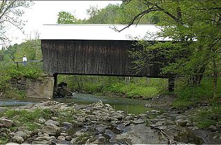
The Braley Covered Bridge, also called the Johnson Covered Bridge and Upper Blaisdell Covered Bridge, is a wooden covered bridge that crosses the Second Branch of the White River in Randolph, Vermont on Braley Covered Bridge Road. It was listed on the National Register of Historic Places in 1974. The bridge was built in 1904 as an uncovered kingspost truss bridge, and was covered in 1909.
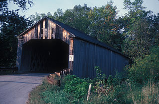
The Gifford Covered Bridge, also called the C.K. Smith Covered Bridge, is a wooden covered bridge that crosses the Second Branch of the White River in Randolph, Vermont on Hyde Road. It was listed on the National Register of Historic Places in 1974. It is one of two bridges in the state that was uncovered when first built, its trusses boxed for shelter.

The South Newfane Bridge is a historic bridge, carrying Parish Hill Road across the Rock River in the village of South Newfane, Vermont. It is a Pratt through truss span, manufactured from rolled I-beams in 1939 to replace a bridge washed away in flooding. It was listed on the National Register of Historic Places in 1992.
The Sanderson Covered Bridge is a historic covered bridge, which carries Pearl Street over Otter Creek in Brandon, Vermont. Built about 1840, it is one of Vermont's oldest covered bridges, and is the only remaining 19th century bridge in Brandon. It was listed on the National Register of Historic Places in 1974.

The Gould's Mill Bridge is a historic Baltimore through truss bridge, carrying Paddock Street across the Black River in Springfield, Vermont. The bridge was built by the Boston Bridge Works Company in 1929 after major flooding in 1927, and is one of the state's few examples of a Baltimore truss. It was listed on the National Register of Historic Places in 2006.

The Iron Bridge at Howard Hill Road is a modern pony truss bridge, carrying Howard Hill Road across the Black River in southeastern Cavendish, Vermont. It is the replacement for a historic 1890 Pratt through truss bridge, which is now in storage. The historic bridge was listed on the National Register of Historic Places in 1982.

The Lincoln Covered Bridge is a historic covered bridge, just south of U.S. Route 4 in West Woodstock, Vermont. Built in 1877, it is one of the only known examples of a wooden Pratt truss bridge in the United States. It was listed on the National Register of Historic Places in 1973.

Bridge 22, also known as the Creamery Bridge is a historic pony truss bridge, carrying Old Creamery Road across the Waits River in Bradford, Vermont. Built in 1934, it is well-preserved late example of a bridge style then passing out of fashion. It was listed on the National Register of Historic Places in 2010.
The Moxley Covered Bridge is a historic covered bridge carrying Moxley Road across the First Branch White River in southern Chelsea, Vermont. Built in 1886-87, it is the town's only surviving 19th-century covered bridge. It was listed on the National Register of Historic Places in 1974.
The Coburn Covered Bridge is a historic covered bridge, carrying Coburn Road over the Winooski River in eastern East Montpelier, Vermont. Built in 1851, it is the town's only surviving 19th-century covered bridge. It was listed on the National Register of Historic Places in 1974.

Bridge 12 is a historic Parker through truss bridge, carrying Boston Post Road across the Missisquoi River in Enosburg, Vermont. Built in 1929 in the wake of Vermont's devastating 1927 floods, it is one a shrinking number of surviving truss bridges on the river. It was listed on the National Register of Historic Places in 2007.

The Willow Creek Bridge, which brought a Pierce County, Nebraska road over Willow Creek, about 6.5 miles (10.5 km) miles south of Foster, Nebraska, was built in 1913. It is a Lattice truss bridge. It was listed on the National Register of Historic Places in 1992. The bridge was moved to Gilman Park in Pierce, Nebraska in 1994.
The Rattlesnake Creek Bridge brings a Cuming County, Nebraska county road over Rattlesnake Creek, 2.8 miles northwest of Bancroft. It was built in 1903 and was listed on the National Register of Historic Places in 1992.
The Perrine Road Bridge is a bridge carrying North Saginaw Road over Sturgeon Creek in Larkin Township, Michigan. It was listed on the National Register of Historic Places in 1999. The bridge was moved in 2001 from its location at the time of nomination to the present location, carrying Perrine Road over Sturgeon Creek.

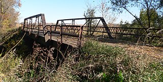
The Robert Parker Coffin Bridge is a Pratt pony truss bridge that spans Buffalo Creek in Long Grove, Illinois, United States. Standing 41 feet (12 m) long, it was built in 1906 by the Joliet Bridge and Iron Company. It is one of the few remaining bridges of its kind in the Chicago area and the state of Illinois, and it was listed on the National Register of Historic Places in 2018.

