
Ashley County is a rural South Arkansas county with a culture, economy, and history based on timber and agriculture. Created as Arkansas's 52nd county on November 30, 1848, Ashley County has seven incorporated municipalities, including Hamburg, the county seat and Crossett, the most populous city. The county is also the site of numerous unincorporated communities and ghost towns. The county is named for Chester Ashley, a prominent lawyer in the Arkansas Territory and U.S. senator from the state from 1844 to 1848.

Arkadelphia is a city in Clark County, Arkansas, United States. As of the 2020 census, the population was 10,380. The city is the county seat of Clark County. It is situated at the foothills of the Ouachita Mountains. Two universities, Henderson State University and Ouachita Baptist University, are located here. Arkadelphia was incorporated in 1857.

Camden is a city in and the county seat of Ouachita County in the south-central part of the U.S. state of Arkansas. The city is located about 100 miles south of Little Rock. Situated on bluffs overlooking the Ouachita River, the city developed because of the river. The recorded history began in 1782 when a Spanish military post was established on the site of an old French trading post called Écore à Fabri. When Ouachita County was formed in 1842, American settlers changed the name to Camden. The city became an important port during the steamboat era when Camden became known as the “Queen City” of the Ouachita. In 1864, Camden became the unintended focus of the Red River Campaign, a major Civil War effort resulting in several significant battles. Camden is known as the producer of M142 HIMARS produced by Lockheed Martin.
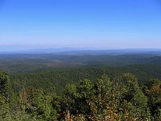
The Ouachita National Forest is a vast congressionally-designated National Forest that lies in the western portion of Arkansas and portions of extreme-eastern Oklahoma, USA.

Poison Springs Battleground State Park is an Arkansas state park located southeast of Bluff City. It commemorates the Battle of Poison Spring in the American Civil War, which was part of the 1864 Camden Expedition, an element of a Union Army initiative to gain control of Shreveport, Louisiana and get a foothold in Texas.
Athens is an unincorporated community in the northeastern corner of Howard County, Arkansas, Arkansas, United States. It is located at the junction of Arkansas Highways 84 and 246.

This is a list of the National Register of Historic Places listings in Ouachita County, Arkansas.
The SS Homer was a sidewheel paddle steamer which plied the waters of the Mississippi River and its tributaries. Built in 1859 in Parkersburg, West Virginia, she was 148 feet (45 m) long, 28 feet (8.5 m) wide, and 5 feet (1.5 m) deep. Her first significant service was in 1860, when she was used as a packet steamer on the Red and Ouachita Rivers, under master and co-owner Samuel Applegate. In 1861, after the start of the American Civil War, she was contracted to the government of the Confederate States of America, and was used to transport men and war materiel. She was used to supply the defenders of Port Hudson, Louisiana, in 1864. That year she was captured by the Union Army forces of General Frederick Steele when she was about 30 miles (48 km) below Camden, Arkansas on the Ouachita River. Steele was at the time engaged in a major expedition whose goal was to reach Shreveport, Louisiana, but had stalled due to Confederate resistance and a lack of supplies. Steele had then occupied Camden, and it was during this occupation that the ship was taken, loaded with grain and other supplies. The Union forces piloted her back to Camden.

The Washington Street Historic District of Camden, Arkansas, encompasses an area that has been a fashionable residential area for much of the city's history. It includes six blocks of Washington Street, three of Graham Street, and three connecting streets. The oldest houses in this area are pre-Civil War Greek Revival houses, built in the 1840s and 1850s when Camden was at its height as a major regional center of the cotton trade. Another round of development took place late in the 19th century after the railroad arrived, resulting in a number of Queen Anne, Colonial Revival, and Classical Revival houses. The last major building spurt took place during southern Arkansas' oil boom in the 1920s and 1930s, when Mission/Spanish Revival, Mediterranean, and English Revival houses were built. The district included 68 contributing properties when it was first listed on the National Register of Historic Places in 2010. Six structures were previously listed separately on the National Register. The district was enlarged in 2018.
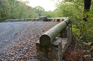
The Buckeye Vista Overlook is a historic scenic overlook in Ouachita National Forest. It is located on Ouachita National Forest Road 38 on the north side of Buckeye Mountain. The overlook is a simple roadside pullout on the north side of the road, with a retaining wall about 70 feet (21 m) long. The wall was built out of quarried stone and mortar in 1935 by a crew of the Civilian Conservation Corps (CCC). It is one of only two CCC-built overlooks in the national forest.
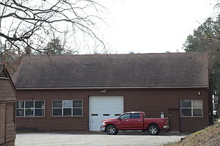
The Poteau Work Center is a utility building located at the Poteau District Headquarters of the Ouachita National Forest in Waldron, Arkansas. It is a rectangular single-story wood-frame building with gable roof, and is distinguished by centrally-located garage doors on each of its long sides. The building was, constructed about 1939 by a work crew of the Civilian Conservation Corps.

The Poteau Work Center Residence No. 2 is a historic house at the Poteau District Headquarters of the Ouachita National Forest in Waldron, Arkansas. It is a single-story wood-frame house, with a shallow-sloped gable roof and novelty siding. Its central entry is sheltered by a porch supported by trios of columns. The building was built c. 1939 by a crew of the Civilian Conservation Corps.

The State Line Marker is a historic boundary marker on the state line between Arkansas and Oklahoma. It is located down a path a short way north of a parking area on Talimena Scenic Drive in Ouachita National Forest, about 17 miles (27 km) northwest of Mena, Arkansas. The marker was originally an octagonal cast iron pipe, with the legend "48 M" on the north face, "1877" on the south side, "ARK" on the east side, and "CHOC" on the west side. The pipe was mounted in a stone and mortar base installed by the United States Forest Service in 1974. The marker was placed in 1877 following a series of controversial surveys to demarcate the border between Arkansas and what was then Indian Territory.
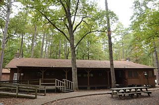
Camp Clearfork is a group use recreational facility in Ouachita National Forest, west of the city of Hot Springs, Arkansas. It is located at the end of Camp Clearfork Trail, south of United States Route 270. The camp was developed in the 1930s by the Civilian Conservation Corps (CCC), and includes cabins, a recreation hall, and Camp Clearfork Reservoir, impounded by a CCC-built dam.
The Guinn Dipping Vat is a historic former cattle dipping facility in Ouachita National Forest, northwest of Mount Ida, Arkansas in the ghost town of Mauldin. It is located south of Forest Road 37 west of United States Route 270.

The Charlton Recreation Area is a public use area of the Ouachita National Forest, located just north of United States Route 270 between Crystal Springs and Mount Ida, Arkansas. The area includes a campground and day use facilities for water-related activities on Walnut Creek, including fishing and swimming. The facilities are organized around a small artificial lake created in 1938 by a crew of the Civilian Conservation Corps by damming the creek. The stone Charlton Dam and Spillway, about 100 feet (30 m) in length, was listed on the National Register of Historic Places 1993, as was the stone Charlton Bathhouse, also built by the CCC in 1938.

The Womble District Administration House No. 1 is a historic house in the Ouachita National Forest. It is located on the north side of United States Route 270, east of Mount Ida and just west of the highway's crossing of Williams Stream. It is a 1+1⁄2-story wood-frame structure, with a side-gable roof, novelty siding, and stone foundation. Its main facade, facing south, has a projecting gable-roofed porch, whose gable is finished in vertical board-and-batten siding. It was built about 1940 by a crew of the Civilian Conservation Corps as the administrative headquarters of the Womble District of the national forest.
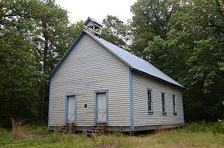
The Hawks Schoolhouse is a historic school building in rural western Perry County, Arkansas. It is located on the south side of County Road 7, in the easternmost section of Ouachita National Forest, near the hamlet of Ava. It is a single-story wood-frame structure, with a gabled roof and weatherboard siding. The roof is capped by a small gable-roofed open belfry. The front facade has a pair of symmetrically placed entrances with simple molding. It was built in 1911, and is a well-preserved example of a district schoolhouse in a rural context.

The Camp Ouachita Girl Scout Camp Historic District encompasses a campground area built by crews of the Civilian Conservation Corps in the 1930s on the northern shore of Lake Sylvia, a man-made lake in the eastern part of Ouachita National Forest. The center of the campground, including its Great Hall and administration buildings, is located at the northern tip of Lake Sylvia, with cabins, comfort facilities, and other infrastructure arrayed around the northern and western sides of the lake. It was the first Girl Scout camp in the state, and is a well-preserved example of the Rustic style of architecture for which the CCC is known.

Highway 80 is an east–west state highway in the Ouachita Mountains. The route of 49.87 miles (80.26 km) begins at AR 28 at Hon and runs east to AR 27 in Danville. The route is maintained by the Arkansas Department of Transportation (ArDOT).


