
Toormakeady or Tourmakeady is a Gaeltacht in south County Mayo in the west of Ireland. It is located between the shores of Lough Mask and the Partry Mountains, and covers 172.26 square kilometres (66.51 sq mi). As at the time of the 2011 census, Toormakeady had a total population of 1,007, having dropped from 1,150 in 1991. Toormakeady is also the name of the principal village in the area.

Erris is a barony in northwestern County Mayo in Ireland consisting of over 230,452 acres (932.61 km2), much of which is mountainous blanket bog. It has extensive sea coasts along its west and north boundaries. The main towns are Belmullet and Bangor Erris. The name Erris derives from the Irish 'Iar Ros' meaning 'western promontory'. The full name is the Iorrais Domnann, after the Fir Bolg tribe, the Fir Domnann. To its north is the wild Atlantic Ocean and the bays of Broadhaven and Sruth Fada Conn and to its west is Blacksod Bay. Its main promontories are the Doohoma Peninsula, Mullet Peninsula, Erris Head, the Dún Chiortáin and Dún Chaocháin peninsulas and Benwee Head.
Glencullen or Glencullin is a rural area which spans two townlands in the parish of Kiltane in County Mayo, Ireland. It lies to the north of Bangor Erris, next to the parish of Kilcommon, Erris, and the Bangor to Kilcommon road runs through the area. The two constituent townlands, Glencullen Lower and Glencullen Upper, are located in an area of blanket bog and extend across approximately 2,125 acres and 2,780 acres respectively.

Glenamoy is a village on the R314 road in the parish of Kilcommon, Erris in the northern part of County Mayo in Ireland.
Ballycong is a small townland southeast of Ballina, located between the River Moy and the Ox Mountains. Ballycong townland has an area of approximately 580 acres (0.91 sq mi), and had a population of 28 people as of the 2011 census.

Doohoma or Doohooma is a townland, peninsula and a census town in the County Mayo Gaeltacht, Ireland. It is located on Ireland's Atlantic coastline overlooking Achill Island and the Mullet Peninsula.
Moylough is a rural village located in County Galway in Ireland. As of the 2016 census, it had a population of 518.

Cogaula is a townland in the civil parish of Islandeady, County Mayo, Ireland. The townland has an area of approximately 1.5 square kilometres (0.58 sq mi), and had a population of 74 people as of the 2011 census.
Drumnamahane Island is a townland in the Barony of Ormond Lower, County Tipperary, Ireland. It is located in the civil parish of Uskane.
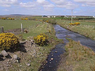
Glinsk is a townland in the County Mayo Gaeltacht in Ireland. It is in the parish of Kilcommon and barony of Erris. Glinsk Mountain is a remote area of upland blanket bog with sea cliffs descending to Broadhaven Bay and continuing along the coast to a height of 255 metres at Benwee Head. The mountain is the source of the Muingnabo River.
Tóin an tSeanbhaile is a small village located on the north east point of Achill Island, Ireland. It lies within the Mayo Gaeltacht.

Kilcommon is a civil parish in Erris, north Mayo consisting of two large peninsulas; Dún Chaocháin and Dún Chiortáin. It consists of 37 townlands, some of which are so remote that they have no inhabitants. Habitation is concentrated mainly along both sides of Sruwaddacon Bay which flows into Broadhaven Bay, in villages including Glengad, Pollathomas, Rossport, Inver and Carrowteige, and in the Glenamoy area further inland.
The civil parish of Kilcommon in Erris, northern County Mayo, Ireland has a total of 37 townlands: small geographic divisions of land in Ireland and Scotland's Outer Hebrides. Townlands originated in Gaelic Ireland, and predate the late-12th-century Anglo-Norman invasion. However, some townland names are derived from British plantations and Norman manors.
Barroosky is a townland within the civil parish of Kilcommon in the County of Mayo, Ireland. It is located within the parish of Kilcommon-Erris.
Sraheens is a townland and boggy area on the island of Achill, County Mayo, Ireland, to the southwest of Achill Sound. The townland, in the southeastern part of Achill, belongs to the barony of Burrishoole in Achill Parish and has an area of 895.47 hectares. It borders Cashel to the west, Derreen to the south, Dooega to the west and Salia to the north.
Derrycorrib is a townland near Glencastle in County Mayo, Ireland. It is situated in the Glencastle Electoral Division within the Kilcommon Civil Parish, which is part of the Erris Barony. As of 2011, 59 people lived in Derrycorrib townland.


