
The Fort Madison Toll Bridge is a tolled, double-decked swinging truss bridge over the Mississippi River that connects Fort Madison, Iowa, and unincorporated Niota, Illinois. A double-track railway occupies the lower deck of the bridge, while two lanes of road traffic are carried on the upper deck. The bridge is about 1 mile (1.6 km) long with a swing span of 525 feet (160 m), and was the longest and largest double-deck swing-span bridge in the world when constructed in 1927. It replaced an inadequate combination roadway/single-track bridge completed in 1887. The main river crossing consists of four 270-foot (82 m) Baltimore through truss spans and a swing span made of two equal arms, 266 feet (81 m) long. In 1999, it was listed in the National Register of Historic Places under the title, Fort Madison Bridge, ID number 99001035. It was also documented as survey number IA-62 by the Historic American Engineering Record, archived at the Library of Congress. Construction and photographic details were recorded at the time in Scientific American magazine.
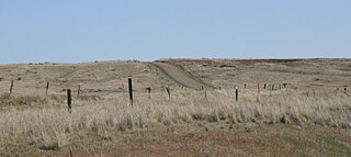
Mullan Road was the first wagon road to cross the Rocky Mountains to the Inland of the Pacific Northwest. It was built by U.S. Army troops under the command of Lt. John Mullan, between the spring of 1859 and summer 1860. It led from Fort Benton, which at the time was in the Dakota Territory, then Idaho Territory from July 1863, and into Montana Territory beginning in May 1864. The road eventually stretched all the way from Fort Walla Walla, Washington Territory, near the Columbia River to the navigational head of the Missouri River, which at the time was the farthest inland port in the world). The road previewed the route approximately followed by modern-day Interstate 15 and Interstate 90 through present-day Montana, Idaho, and Washington.
The Ponakin Bridge is a historic Post truss bridge spanning the Nashua River in northern Lancaster, Massachusetts. The bridge was built in 1871, and originally carried the main north–south road, which was bypassed by the construction of Massachusetts Route 70. It is now unsafe and closed even to pedestrians. The bridge, with a design once common but now extremely rare, was listed on the National Register of Historic Places in 1979.

The Lewis and Clark Bridge is a historic bridge in Wolf Point, Montana, which once carried Montana Highway 13 across the Missouri River between McCone and Roosevelt counties. It is also known as Wolf Point Bridge, Missouri River Bridge, or Site No. 24RV438. The bridge is a five-span Pennsylvania through truss; its longest span is the longest through truss span in the state at 400-foot (120 m). Completed in 1930 by the Missouri Valley Bridge and Iron Company, the bridge was the first bridge across the Missouri River at Wolf Point and the only bridge along the river for a 350-mile (560 km) stretch. The bridge's opening ceremony, which took place on July 9, drew over 10,000 visitors and included five bands and a fireworks display. After its completion, the bridge became a popular tourist attraction for motorists in northeastern Montana and a point of civic pride for Wolf Point's residents.

Snowden Bridge is a high-clearance, vertical-lift railroad bridge, built in 1913, that spans the Missouri River between Roosevelt and Richland Counties in Montana, USA, between Bainville and Fairview, Montana, and near Fort Union Trading Post National Historic Site and the ghost town of Mondak near Montana's eastern border with North Dakota. Snowden Bridge is a near twin of the Fairview Bridge, which crosses the Yellowstone River in North Dakota, both bridges having been built by Montana Eastern Railway within 10 miles (16 km) of each other over different rivers in different states.

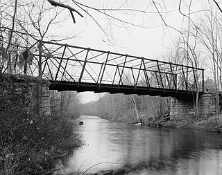
The Fink-Type Truss Bridge, also known as the Hamden Bridge, carried Hamden Road/River Road over the South Branch Raritan River, the border between Clinton Township and Franklin Township, at Hamden near the Allerton section of Hunterdon County, New Jersey. The bridge was built in 1857 by the Trenton Locomotive and Machine Manufacturing Company. It consisted of a single-span through truss 100 feet (30 m) long, 15 feet (4.6 m) wide, and 19 feet (5.8 m) high.
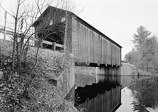
The Hancock–Greenfield Bridge is a historic covered bridge carrying Forest Road over the Contoocook River at the town line between Hancock and Greenfield, New Hampshire. The New Hampshire Department of Transportation covered bridge database refers to it as County Bridge. Built in 1937, it is the first wooden covered bridge in the northeastern United States to use modern engineering techniques. The bridge was listed on the National Register of Historic Places in 1981.

The Toston Bridge is a site on the National Register of Historic Places spanning the Missouri River, on an abandoned segment of old U.S. Route 287, at Toston, Montana. It was added to the Register on July 20, 2005.

Bridge No. 4, near La Crosse, Wisconsin, United States, was built in 1902. It is a bowstring truss bridge built by the Clinton Bridge Company. It was listed on the National Register of Historic Places in 1980 and documented by the Historic American Engineering Record in 1987.
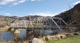
Hardy Bridge is a Warren through truss, three-span, two-lane bridge in the western United States. It crosses the Missouri River and is located at milepost 6 on Old U.S. Route 91, about fourteen miles (23 km) southwest of Cascade, Montana, which is southwest of Great Falls.
The Eldean Covered Bridge is a historic covered bridge spanning the Great Miami River in Miami County, Ohio north of Troy. Built in 1860, it is one of the nation's finest surviving examples of a Long truss, patented in 1830 by engineer Stephen H. Long. At 224 feet (68 m) in length for its two spans, it is the longest surviving example of its type. It was listed on the National Register of Historic Places in 1975, and was designated a National Historic Landmark in 2016.

The DML Butler Bridge is a historic bridge over the North Platte River in Carbon County, Wyoming, United States, that is listed on the National Register of Historic Places (NRHP).

The Little Missouri River Bridge, also known as the Nachitoch Bluff Bridge, is a historic bridge between rural southern Clark County, Arkansas and Nevada County, Arkansas. Now closed to traffic, it once carried County Road 179 over the Little Missouri River. Believed to be built in 1910, it is the only known Camelback Pratt truss bridge in the state. Its main span measures 185 feet (56 m), with a secondary Pratt truss span measuring 110 feet (34 m) in length, and there are I-beam-supported approaches on either side, giving the bridge a total length of 315 feet (96 m). The bridge is located on the historic route of the Natchitoches Trace, an early colonial French-Spanish trail through the area.

The Middle Fork of the Little Red River Bridge, also known as the Shirley Railroad Bridge, is a historic bridge in Shirley, Arkansas. It is a single-span iron Baltimore through truss, with a main span 153 feet (47 m) long, and steel beam approach spans giving it a total length of 339 feet (103 m). The main span rests on large concrete piers set in the river. The bridge was built in 1908 for the Missouri and North Arkansas Railroad, and carried the railroad until 1949. In 1978 the tracks were covered by a concrete deck, and the bridge was converted to single-lane vehicular road use, carrying County Road 125.

Eveland Bridge is located southwest of Oskaloosa, Iowa, United States. It carried traffic of Fulton Avenue over the Des Moines River, spanning 647 feet (197 m). After receiving multiple petitions, the Mahaska County Board of Supervisors decided in April 1875 to build a bridge, replacing a ferry service that operated at this point along the river beginning in 1854. They contracted with the Fort Wayne Bridge Works of Fort Wayne, Indiana, to build the new bridge for $25,200. It was designed by C. W. Tracy, a civil engineer. The Whipple through truss span was completed in the summer of 1877. This style was rarely chosen for wagon trusses in Iowa, which means few were built and fewer remain standing. Its deck has subsequently deteriorated and the bridge has been closed to traffic. The Eveland Bridge was listed on the National Register of Historic Places in 1998.

The Jeffersonville Bridge is a steel girder bridge carrying Vermont Route 108 across the Lamoille River, just north of the village of Jeffersonville, Vermont. It was built in 2014, replacing a Parker through truss bridge built in 1931; the latter bridge was listed on the National Register of Historic Places in 1991.

The Scenic Bridge crossing Clark Fork River about 4 miles (6.4 km) east of Tarkio in Mineral County, Montana, was built in 1928. It is located at Milepost 0 on Old U.S. Route 10 West. The bridge has also been denoted 24MN304 and MDT No. L31012000+08. It was listed on the National Register of Historic Places in 2010.

The Station Road Bridge, near Brecksville, Ohio, was built in 1882. It spans the Cuyahoga River between Cuyahoga County and Summit County, Ohio. It was listed on the National Register of Historic Places in 1979.

The New Hampton Pony Pratt Truss Bridge is a historic pony Pratt truss bridge on Shoddy Mill Road in New Hampton of Lebanon Township, Hunterdon County, New Jersey. It crosses the Musconetcong River between Lebanon Township, Hunterdon County and Washington Township, Warren County. It was designed by Francis C. Lowthorp and built in 1868 by William Cowin of Lambertville, New Jersey. The bridge was added to the National Register of Historic Places on July 26, 1977 for its significance in engineering, industry and transportation. It is one of the few early examples of iron Pratt truss bridges remaining in the United States. It was later documented by the Historic American Engineering Record in 1991. It was added as a contributing property to the New Hampton Historic District on April 6, 1998.

The Joliet Bridge, in Carbon County, Montana, near Joliet, is a Pratt through truss bridge built in 1901. It was listed on the National Register of Historic Places in 1986.


