Braddock Heights is an unincorporated community and census-designated place (CDP) in Frederick County, Maryland, United States. The population was 2,608 at the 2010 census. The local ZIP codes are 21714 and 21703.

Middletown is a town in Frederick County, Maryland, United States. The population was 4,136 as of the 2010 census. Located in the Middletown Valley that stretches between the Catoctin Mountains on the east and South Mountain on the west, the town reportedly gained its name from its location midway between those ranges.

Boonsboro is a town in Washington County, Maryland, United States, located at the foot of South Mountain. It nearly borders Frederick County and is proximate to the Antietam National Battlefield. The population was 3,779 at the 2020 census.

The Great Appalachian Valley, also called The Great Valley or Great Valley Region, is one of the major landform features of eastern North America. It is a gigantic trough, including a chain of valley lowlands, and the central feature of the Appalachian Mountains system. The trough stretches about 1,200 miles (1,900 km) from Quebec in the north to Alabama in the south and has been an important north–south route of travel since prehistoric times.
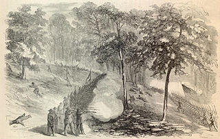
The Battle of South Mountain, known in several early Southern accounts as the Battle of Boonsboro Gap, was fought on September 14, 1862, as part of the Maryland campaign of the American Civil War. Three pitched battles were fought for possession of three South Mountain passes: Crampton's, Turner's, and Fox's Gaps.

Catoctin Mountain, along with the geologically associated Bull Run Mountains, forms the easternmost mountain ridge of the Blue Ridge Mountains, which are in turn a part of the Appalachian Mountains range. The ridge runs northeast–southwest for about 50 miles (80 km) departing from South Mountain near Emmitsburg, Maryland, and running south past Leesburg, Virginia, where it disappears into the Piedmont in a series of low-lying hills near New Baltimore, Virginia. The ridge forms the eastern rampart of the Loudoun and Middletown valleys.

Crampton's Gap, also known as Crampton Gap, is a wind gap on South Mountain in Maryland.

Jesse Lee Reno was a career United States Army officer who served in the Mexican–American War, in the Utah War, on the western frontier and as a Union General during the American Civil War from West Virginia. Known as a "soldier's soldier" who fought alongside his men, he was killed while commanding a corps at Fox's Gap during the Battle of South Mountain. Reno, Nevada; Reno County, Kansas; Reno, Ohio; El Reno, Oklahoma; Reno, Pennsylvania; Fort Reno (Oklahoma); and Fort Reno Park in Washington, D.C. were named after him.

Turner's Gap is a wind gap in the South Mountain Range of the Blue Ridge Mountains, located in Frederick County and Washington County, Maryland. The gap is traversed by U.S. Route 40 Alternate, the old National Pike. The Appalachian Trail also crosses the gap along the ridgeline.

Samuel Garland Jr. was an American attorney from Virginia and Confederate general during the American Civil War. He was killed in action during the Maryland Campaign while defending Fox's Gap at the Battle of South Mountain.

The Braddock Road was a military road built in 1755 in what was then British America and is now the United States. It was the first improved road to cross the barrier of the successive ridgelines of the Appalachian Mountains. It was constructed by troops of Virginia militia and British regulars commanded by General Edward Braddock of the Coldstream Guards, part of an expedition to conquer the Ohio Country from the French at the beginning of the French and Indian War, the North American portion of the Seven Years' War. George Washington was an aide-de-camp to General Braddock who accompanied the expedition. The expedition gave him his first field military experience along with other American military officers. A number of these men would profit from this experience during the Revolutionary War.
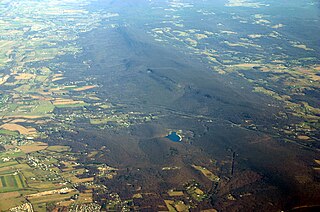
South Mountain is the northern extension of the Blue Ridge Mountain range in Maryland and Pennsylvania. From the Potomac River near Knoxville, Maryland in the south to Dillsburg, Pennsylvania in York County, Pennsylvania in the north, the 70-mile-long (110 km) range separates the Hagerstown and Cumberland valleys from the Piedmont regions of the two states.
Haystack Mountain is a mountain ridge in the Ridge and Valley region of the Appalachian Mountains, located in western Maryland just west of the city of Cumberland. The mountain forms the southern wall of the Cumberland Narrows.
The Hagerstown and Frederick Railway, now defunct, was an American railroad of central Maryland built in the 19th and 20th centuries.
Lambs Knoll is a peak of South Mountain on the border of Washington County and Frederick County in the state of Maryland. The 1,758 feet (536 m) peak is the second tallest on South Mountain in Maryland behind Quirauk Mountain.

U.S. Route 40 Alternate is the U.S. Highway designation for a former segment of U.S. Route 40 (US 40) through Garrett and Allegany counties in Maryland. The highway begins at US 40 near exit 14 on Interstate 68 (I-68) and runs 31.80 miles (51.18 km) eastward to Cumberland, where it ends at exit 44 on I-68. Alt US 40 is maintained by the Maryland State Highway Administration (MDSHA).
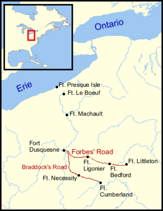
The Forbes Road, a historic military roadway in what was then British America, was initially completed in 1758 from Carlisle, Pennsylvania, to the French Fort Duquesne at the junction of the Allegheny and Monongahela rivers in what is now downtown Pittsburgh, via Fort Loudon, Fort Lyttleton, Fort Bedford and Fort Ligonier. The road, initially about 220 miles long, was named for Brigadier General John Forbes, the commander of the 1758 British-led expedition that built the road during the French and Indian War. The Forbes Road and Braddock's Road were the two main land routes that the British cut west through the wilderness during the war. The task was complicated by the Appalachian Mountains' steep northeast-to-southwest ridges, a generally broken terrain between the ridges, heavy forestation, and numerous swamps and rivers.
U.S. Route 40 Alternate (US 40 Alternate) is an alternate route of US 40 in the U.S. state of Maryland. The highway runs 22.97 miles (36.97 km) from Potomac Street in Hagerstown east to US 40 in Frederick. US 40 Alternate parallels US 40 and much of Interstate 70 (I-70) to the south through eastern Washington County and western Frederick County. The alternate route connects Hagerstown and Frederick with Funkstown, Boonsboro, Middletown, and Braddock Heights. US 40 Alternate crosses two major north–south components of the Blue Ridge Mountains that separate the Great Appalachian Valley and the Piedmont: South Mountain between Boonsboro and Middletown and Catoctin Mountain, which is locally known as Braddock Mountain, at Braddock Heights.

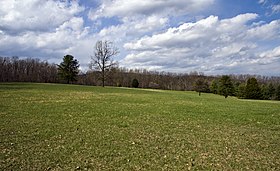
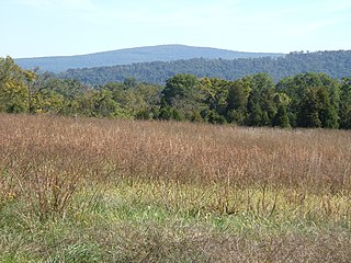
The Turner's and Fox's Gaps Historic District comprises the Civil War-era battlefield involved in the Battle of South Mountain, which took place on September 14, 1862. The district extends on the west to the slopes of South Mountain in the area of Zittlestown, and to the east beyond the foot of the mountain to the small community of Bolivar. The district is characterized by steep mountain terrain in the west and open farmland in the east, with Turner's Gap to the north and Fox's Gap to the south. The district includes 115 contributing buildings and structures. The most significant contributing buildings are the Mountain House Inn and the White House Inn, or Beachley House. Also included in the list is the Reno Monument at Fox's Gap, shown at right. The Old National Pike, now known as U.S. 40 Alternate, passes over South Mountain at Turner's Gap.
The gaps of the Allegheny, meaning gaps in the Allegheny Ridge in west-central Pennsylvania, is a series of escarpment eroding water gaps along the saddle between two higher barrier ridge-lines in the eastern face atop the Allegheny Ridge or Allegheny Front escarpment. The front extends south through Western Maryland and forms much of the border between Virginia and West Virginia, in part explaining the difference in cultures between those two post-Civil War states. While not totally impenetrable to daring and energetic travelers on foot, passing the front outside of the water gaps with even sure footed mules was nearly impossible without navigating terrain where climbing was necessary on slopes even burros would find extremely difficult.