
Carbon County is a county located in the U.S. state of Montana. As of the 2020 census, the population was 10,473. Its county seat is Red Lodge.

James Barney Marsh was an American engineer and bridge designer. He patented a new design for arch bridges. Marsh gave Archie Alexander, the first African-American to graduate as an engineer from Iowa State University, his first job. Marsh worked in the bridge building business for over 50 years, and several of his bridges are listed in the National Register of Historic Places.

The North Entrance Road Historic District comprises Yellowstone National Park's North Entrance Road from Gardiner, Montana to the park headquarters at Mammoth Hot Springs, Wyoming, a distance of a little over five miles (8 km). The North Entrance Road was the first major road in the park, necessary to join the U.S. Army station at Fort Yellowstone to the Northern Pacific Railroad station at Gardiner. The road includes the Roosevelt Arch at the northern boundary of the park and winds through rolling terrain before crossing the Gardner River and joining the Grand Loop Road.

The Tenth Street Bridge is a concrete arch bridge in Great Falls, Montana, spanning the Missouri River. The bridge was designed by engineer Ralph Adams of Spokane, Washington and Great Falls architect George Shanley, and was completed in 1920. It was the longest open-spandrel ribbed concrete arch bridge in Montana.

Wilson River Bridge, also known as Wilson River Bridge at Tillamook or Wilson River Bridge No. 01499, is a bridge near Tillamook, Oregon, United States. The 1931 bridge was designed by Conde McCullough in the Classical Revival and Art Deco styles. It covers a span of 180 feet (55 m) and brings coastal U.S. Route 101 (US 101) over the Wilson River.

The Generals' Highway Stone Bridges, built in 1930, are part of the Generals' Highway from the General Grant Grove of giant sequoias in Kings Canyon National Park through Sequoia National Park. One bridge spans the Marble Fork of the Kaweah River in a wooded setting, while the other, similar bridge spans Clover Creek in a bare canyon.

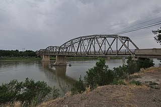
The Lewis and Clark Bridge is a historic bridge in Wolf Point, Montana, which once carried Montana Highway 13 across the Missouri River between McCone and Roosevelt counties. It is also known as Wolf Point Bridge, Missouri River Bridge, or Site No. 24RV438. The bridge is a five-span Pennsylvania through truss; its longest span is the longest through truss span in the state at 400-foot (120 m). Completed in 1930 by the Missouri Valley Bridge and Iron Company, the bridge was the first bridge across the Missouri River at Wolf Point and the only bridge along the river for a 350-mile (560 km) stretch. The bridge's opening ceremony, which took place on July 9, drew over 10,000 visitors and included five bands and a fireworks display. After its completion, the bridge became a popular tourist attraction for motorists in northeastern Montana and a point of civic pride for Wolf Point's residents.

The Zion – Mount Carmel Highway is a 25-mile (40 km) long road in Washington and Kane counties in southern Utah, United States, that is listed on the National Register of Historic Places and is a National Historic Civil Engineering Landmark.

The Hayden Arch Bridge is a concrete arch bridge on old US 14/US 16 in Park County, Wyoming, United States, that is listed on the National Register of Historic Places {NRHP).

The Dearborn River High Bridge is a Pratt half-deck truss bridge built in 1897, and has been placed on the National Register of Historic Places as it is one of the few bridges of its type left standing in the United States. On a half-deck bridge, the deck is attached in the center rather than, as is more common, top or bottom of the superstructure. It crosses the Dearborn River on Lake Bean Road about 15 miles (24 km) southwest of Augusta, Montana. The unusual design of the Dearborn River High Bridge suits it to carry light loads across high/deep crossings. It has four spans and a wooden plank deck. It is the last standing pin-connected Pratt half-deck truss bridge left in the United States. Construction cost was $9,997. Construction began in 1896 and completed in 1897.
The Big Blue River Bridge is a National Register of Historic Places-listed bridge located in Fillmore County, Nebraska, near the village of Grafton. The bridge is one of two listed on the Register within Fillmore County, the other being the Deering Bridge. The bridge is a single-span, concrete, spandrel arch facility. The site was first designed by state engineers in 1917, and was constructed in 1918. At the time of the construction, the facility's architectural style was the main bridge design in the state. The bridge still retains all original building materials, and has only undergone slight maintenance since construction. The bridge carries Fillmore County Road 6 over the West Fork of the Big Blue River.

The South Fork Bridge is a historic bridge spanning the South Fork Saline River in Fountain Lake, Arkansas. It formerly carried Arkansas Highway 128, whose modern bridge now stands just to the south, a short way east of its junction with Arkansas Highway 5. It is a two-span concrete closed-spandrel arch structure, with spans of 57 feet (17 m) and a roadway width of 16 feet (4.9 m). It was built in 1928 by a county crew, after major flooding in 1927 damaged road infrastructure in the area.
Completed in 1926 at a cost of $305,000, the Bell Street Bridge crosses the Yellowstone River in Glendive, Montana. Designed by the Montana Highway Commission and built by contractor Boomer, McGuire & Blakesley, the 1,352 feet (412 m) long, 20 feet (6.1 m) wide bridge consists of six Warren through truss spans, each roughly 219 feet (67 m) long, and a concrete approach span about 38 feet (12 m) long. It was listed on the National Register of Historic Places in 1988. At one time the main highway bridge over the river, Montana DOT rehabilitated and converted it for pedestrian use in 1992 when the bridge on the I-94 Business Loop was built 300’ to the north.

The Scenic Bridge crossing Clark Fork River about 4 miles (6.4 km) east of Tarkio in Mineral County, Montana, was built in 1928. It is located at Milepost 0 on Old U.S. Route 10 West. The bridge has also been denoted 24MN304 and MDT No. L31012000+08. It was listed on the National Register of Historic Places in 2010.

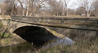
The Joliet Bridge, in Carbon County, Montana, near Joliet, is a Pratt through truss bridge built in 1901. It was listed on the National Register of Historic Places in 1986.

The Gebo Barn, in Carbon County, Montana near Fromberg, Montana, was built during 1907 to 1909. It was listed on the National Register of Historic Places in 2005.
Coalville, Montana, also known as Gebo, Montana, was a community by the Gebo Mine, in Carbon County, Montana near Fromberg, Montana.

The Gebo Cemetery, in Carbon County, Montana near Fromberg, Montana, was established in 1899 to serve the coal mining town of Gebo, Montana, which had population of 500 to 1,000 in the early 1900s, but was virtually abandoned after the Gebo Mine ceased operation in 1912. It was listed on the National Register of Historic Places in 1993.
The Henry Gebo House, in Carbon County, Montana east of Bridger, Montana, was built in 1909. It was listed on the National Register of Historic Places in 1987.

The First Street Bridge in Napa, California carries First Street over the Napa River. It was built in 1914 and was listed on the National Register of Historic Places in 2004.


