Gaines, Michigan

Last updated

Gaines, Michigan
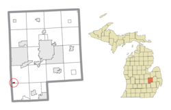
Gaines, MI location.png
Location within Genesee County
USA Michigan location map.svg
Red pog.svg
Gaines
Location within the state of Michigan
Coordinates: 42°52′20″N83°54′47″W / 42.87222°N 83.91306°W / 42.87222; -83.91306
Country United States
State Michigan
County Genesee
Township Gaines
Settled1856
Platted 1859
Incorporated1875
Government
  Type Village council
  PresidentConnie Greene
Area
[1]
  Total0.37 sq mi (0.97 km2)
  Land0.37 sq mi (0.97 km2)
  Water0.00 sq mi (0.00 km2)
Elevation
856 ft (261 m)
Population
 (2020)
  Total377
  Density1,008.02/sq mi (389.59/km2)
Time zone UTC-5 (EST)
  Summer (DST) UTC-4 (EDT)
ZIP code(s)
48436
Area code 989
FIPS code 26-31200 [2]
GNIS feature ID0626594 [3]

Gaines is a village in Genesee County in the U.S. state of Michigan. The population was 380 at the 2010 census. The village is within Gaines Township.

Contents

History

The Village of Gaines area did not see a settler until 1856. The first passenger train passed through the future village site on July 4, 1856, and a post office, Gaines Station, was established that same year. In 1859, the village was platted. [4] The Grand Trunk Western Railroad depot, built in 1884. [5] The Village of Gaines was incorporated in 1875. [6]

The Gaines Train Station saw its last passengers boarded and disembarked in 1957. In the 1970s, a business occupied the building. After setting vacant for years, the S.O.S. – Save Our Station group of Gaines residents organized in 1992 to restore the station. SOS later incorporated as the nonprofit Gaines Station Incorporated. After $100,000 in repairs in 1997, the station was turned over to the village. The station then began its use as the smallest branch of the Genesee District Library. On July 15, 2017, a Michigan Historical Marker was unveiled for the station. [7]

In August 2016, the village's lone police officer retired. By March 9, 2017, the village council formally dissolved the police department and Gaines Township purchased the police car. [8]

Government

The village was incorporated under the General Law Village Act provisions making its government form a weak mayor-council. The governing body is the Village Council which comprises the Village President, its presiding officer, and 6 trustees. Treasurer and Clerk are elected. The trustee are elected for two-year terms. The elected officers are elected to one year terms. [9] Police services are provided by Gaines Township. [8]

Village Council

YearPresidentCouncilors
2014Sam StiffCarol Erickson, Barb Ferris, James Savage, Kathy Volkening, Diane Nowak, Sherry Lang
2016Diane Nowak, Emily Alexander, Melissa Neal,

Barb Ferris, James Savage, Carol Erickson [10]

2022Connie GreeneDiane Nowak, Wayne McGuire, Valerie DeLauter, Mark Sanborn, Taunya Merak, Ronda Roach
DistrictNumberOfficeholder
U.S. Representative5
State Senate27
State Representative49
County Commissioner6
District Court4th Division - FentonMark McCabe, Chief Judge
School District Swartz Creek Multiple; see article
Community College C.S. Mott Multiple: see article
Polling Location

Geography

According to the United States Census Bureau, the village has a total area of 0.37 square miles (0.96 km2), all land. [11] It lies within Gaines Township at the border with Argentine Township.

Demographics

Historical population
CensusPop.Note
1880 344
1890 304−11.6%
1900 240−21.1%
1910 238−0.8%
1920 2609.2%
1930 250−3.8%
1940 2687.2%
1950 35231.3%
1960 3879.9%
1970 4085.4%
1980 4407.8%
1990 427−3.0%
2000 366−14.3%
2010 3803.8%
2020 377−0.8%
Source: Census Bureau.
Census 1960- 2000, 2010.

2010 census

As of the census [12] of 2010, there were 380 people, 154 households, and 98 families living in the village. The population density was 1,027.0 inhabitants per square mile (396.5/km2). There were 171 housing units at an average density of 462.2 per square mile (178.5/km2). The racial makeup of the village was 97.9% White, 0.3% African American, 0.5% Native American, 0.3% from other races, and 1.1% from two or more races. Hispanic or Latino of any race were 1.8% of the population.

There were 154 households, of which 33.8% had children under the age of 18 living with them, 50.0% were married couples living together, 7.8% had a female householder with no husband present, 5.8% had a male householder with no wife present, and 36.4% were non-families. 31.8% of all households were made up of individuals, and 14.2% had someone living alone who was 65 years of age or older. The average household size was 2.47 and the average family size was 3.09.

The median age in the village was 38.5 years. 26.6% of residents were under the age of 18; 6.9% were between the ages of 18 and 24; 26.5% were from 25 to 44; 28% were from 45 to 64; and 12.1% were 65 years of age or older. The gender makeup of the village was 50.3% male and 49.7% female.

2000 census

As of the census [2] of 2000, there were 366 people, 143 households, and 98 families living in the village. The population density was 1,205.5 inhabitants per square mile (465.4/km2). There were 155 housing units at an average density of 510.5 per square mile (197.1/km2). The racial makeup of the village was 93.72% White, 1.91% African American, 0.55% Asian, 1.37% from other races, and 2.46% from two or more races. Hispanic or Latino of any race were 1.64% of the population.

There were 143 households, out of which 33.6% had children under the age of 18 living with them, 51.0% were married couples living together, 11.9% had a female householder with no husband present, and 30.8% were non-families. 25.9% of all households were made up of individuals, and 8.4% had someone living alone who was 65 years of age or older. The average household size was 2.56 and the average family size was 2.99.

In the village, the population was spread out, with 28.1% under the age of 18, 10.1% from 18 to 24, 28.1% from 25 to 44, 24.6% from 45 to 64, and 9.0% who were 65 years of age or older. The median age was 35 years. For every 100 females, there were 104.5 males. For every 100 females age 18 and over, there were 92.0 males.

The median income for a household in the village was $44,375, and the median income for a family was $46,250. Males had a median income of $50,625 versus $22,500 for females. The per capita income for the village was $19,790. About 8.5% of families and 10.3% of the population were below the poverty line, including 13.6% of those under age 18 and 18.5% of those age 65 or over.
Related Research Articles

<span class="mw-page-title-main">Argentine Township, Michigan</span> Civil township in Michigan, United States

Argentine Township is a civil township of Genesee County in the U.S. state of Michigan. As of the 2020 census, the township population was 7,091, up from 6,912 at the 2010 census.

<span class="mw-page-title-main">Atlas Township, Michigan</span> Civil township in Michigan, United States

Atlas Township is a civil township of Genesee County in the U.S. state of Michigan. As of the 2020 census, the township population was 8,352, up from 7,993 at the 2010 census.

<span class="mw-page-title-main">Burton, Michigan</span> City in Michigan, United States

Burton is a city in Genesee County in the state of Michigan and a suburb of Flint. The population was 29,999 at the 2010 census, making Burton the second largest city in Genesee County.

<span class="mw-page-title-main">Clio, Michigan</span> City in Michigan, United States

Clio is a city in Genesee County in the U.S. state of Michigan. The city is located entirely within Vienna Township, but is administratively autonomous. As of the 2010 census, the city had a population of 2,646.

<span class="mw-page-title-main">Davison Township, Michigan</span> Civil township in Michigan, United States

Township of Davison is a civil township of Genesee County in the U.S. state of Michigan consisting of the survey township of North 7 East 8 less the administratively autonomous city of Davison. The population was 19,575 at the 2010 census, up from 17,722 at the 2000 census.

<span class="mw-page-title-main">Fenton, Michigan</span> City in Michigan, United States

Fenton is a city in the U.S. state of Michigan that lies mostly in Genesee County, with small portions in neighboring Oakland County and Livingston County. It is part of the Flint Metropolitan statistical area.

<span class="mw-page-title-main">Forest Township, Genesee County, Michigan</span> Civil township in Michigan, United States

Forest Township is a civil township of Genesee County in the U.S. state of Michigan. Survey township designation is 9 north and 8 east. The population was 4,702 at the 2010 census, which makes Forest Township the least populated township in Genesee County.

<span class="mw-page-title-main">Gaines Township, Genesee County, Michigan</span> Civil township in Michigan, United States

Gaines Township is a civil township of Genesee County in the U.S. state of Michigan. The population was 6,820 at the 2010 census.

<span class="mw-page-title-main">Grand Blanc, Michigan</span> City in Michigan, United States

Grand Blanc is a city in Genesee County in the U.S. state of Michigan and a suburb of Flint. The population was 7,784 as of the 2020 US Census.

<span class="mw-page-title-main">Montrose, Michigan</span> City in Michigan, United States

Montrose is a city in Genesee County in the U.S. state of Michigan. The population was 1,743 at the 2020 census. Once part of the surrounding Montrose Township, the city itself incorporated in 1980, and both are now administered autonomously.

<span class="mw-page-title-main">Mount Morris, Michigan</span> City in Michigan, United States

Mount Morris is a city in Genesee County in the U.S. state of Michigan. The population was 3,086 at the 2010 census. The city is bordered by Mount Morris Township on the west and Genesee Township on the east. It was named after Mount Morris, New York, because many of the early settlers had come from there.

<span class="mw-page-title-main">Mundy Township, Michigan</span> Charter township in Michigan, United States

The Charter Township of Mundy is a charter township of Genesee County in the U.S. state of Michigan. The population was 15,082 at the 2010 census.

<span class="mw-page-title-main">Otisville, Michigan</span> Village in Michigan, United States

Otisville is a village in Forest Township, Genesee County in the U.S. state of Michigan. The population was 864 at the 2010 census. It is located along M-15, just south of M-57.

<span class="mw-page-title-main">Richfield Township, Genesee County, Michigan</span> Civil township in Michigan, United States

Richfield Township is a civil township of Genesee County in the U.S. state of Michigan. The population was 8,730 at the 2010 census, up from 8,170 at the 2000 census.

<span class="mw-page-title-main">Swartz Creek, Michigan</span> City in Michigan, United States

Swartz Creek is a city in Genesee County in the U.S. state of Michigan. The population was 5,758 at the 2010 census. The city is a suburb of Flint and has incorporated land formerly within Flint Charter Township, Gaines Township, and Clayton Township, but is administratively autonomous from all three.

<span class="mw-page-title-main">Lakeview, Michigan</span> Village in Michigan, United States

Lakeview is a village in Cato Township in Montcalm County of the U.S. state of Michigan. The population was 1,007 at the 2010 census. The village is within Cato Township.

<span class="mw-page-title-main">Birch Run Township, Michigan</span> Civil township in Michigan, United States

Birch Run Township is a civil township of Saginaw County in the U.S. state of Michigan. As of the 2010 Census, the township population was 6,033. The village of Birch Run is located within the township.

<span class="mw-page-title-main">Saginaw Charter Township, Michigan</span> Charter township in Michigan, United States

Saginaw Charter Township is a charter township of Saginaw County in the U.S. state of Michigan. The population was 41,679 at the 2020 census. The city of Saginaw is adjacent to the township to the southeast, but is administratively autonomous.

Lennon is a village in the U.S. state of Michigan. The population was 511 at the 2010 census. The village is located along M-13 within Venice Township in Shiawassee County to the west and Clayton Township in Genesee County to the east.

<span class="mw-page-title-main">Otter Lake, Michigan</span> Village in Michigan, United States

Otter Lake is a village in the U.S. state of Michigan. Approximately half of the village lies in Marathon Township in Lapeer County and half in Forest Township in Genesee County. The population was 389 at the 2010 census. The village is named after the nearby body of water which had numerous otters.

References

  1. "2020 U.S. Gazetteer Files". United States Census Bureau. Retrieved May 21, 2022.
  2. 1 2 "U.S. Census website". United States Census Bureau . Retrieved January 31, 2008.
  3. "US Board on Geographic Names". United States Geological Survey. October 25, 2007. Retrieved January 31, 2008.
  4. Wood, Edwin O. (1916). History of Genesee County, Michigan, Her People, Industries and Institutions. Michigan Historical Commission.
  5. "Gaines, MI". Michiganrailroads.com. Retrieved June 19, 2020.
  6. Wood, Edwin O. (1916). "Villages of Genesee, Part II". The History of Genesee, Michigan . Retrieved September 19, 2017.
  7. Rocha, Lania (July 20, 2017). "From rails to tales". Swartz Creek View. The View Newspaper Group. Retrieved June 19, 2020.
  8. 1 2 Rocha, Lania (March 9, 2017). "Twp. buys village police cruiser". Swartz Creek View. JAMS Media. Retrieved March 30, 2017.
  9. "Villages". Municipal Report: Organization of City and Village Government in Michigan (PDF) (Report) (Updated ed.). Ann Arbor, Michigan: Michigan Municipal League. January 2011. pp. 1, 2, 10. Retrieved February 15, 2016.
  10. Johnson, Bob (November 8, 2016). "See live election results for Genesee County races here". Flint Journal. Mlive Media Group. Retrieved March 30, 2017.
  11. "US Gazetteer files 2010". United States Census Bureau. Archived from the original on July 2, 2012. Retrieved November 25, 2012.
  12. "U.S. Census website". United States Census Bureau . Retrieved November 25, 2012.