Gemini Mountains, Queensland

Last updated

Gemini Mountains
Queensland
Castor and Pollux, the Gemini Mountains.jpg
Castor and Pollux, the Gemini Mountains
Australia Queensland location map.svg
Red pog.svg
Gemini Mountains
Coordinates 22°26′21″S147°52′20″E / 22.4391°S 147.8722°E / -22.4391; 147.8722 (Gemini Mountains (centre of locality))
Population65 (2021 census) [1]
 • Density0.1167/km2 (0.3024/sq mi)
Postcode(s) 4721
Area556.8 km2 (215.0 sq mi)
Time zone AEST (UTC+10:00)
Location
LGA(s) Isaac Region
State electorate(s) Burdekin
Federal division(s) Capricornia
Suburbs around Gemini Mountains:
Kilcummin Kilcummin Winchester
Kilcummin Gemini Mountains Dysart
Wolfang Wolfang Dysart

Gemini Mountains is a rural locality in the Isaac Region, Queensland, Australia. [2] In the 2021 census, Gemini Mountains had a population of 65 people. [1]

Contents

Geography

The Goonyella railway line forms most of the western boundary of the locality, with Mount McLaren railway station serving Graincorp's grain handling facility ( 22°20′50″S147°45′21″E / 22.3472°S 147.7558°E / -22.3472; 147.7558 (Mount McLaren railway station) ). [3] [4] [5]

One of the four segments of the Peak Range National Park is in the south of the locality. [4] [6]

The locality contains the following mountains:

The land use is predominantly crop growing with some grazing on native vegetation. [4]

History

The locality takes its name from the mountain range Gemini Mountains ( 22°28′00″S147°53′00″E / 22.4666°S 147.8833°E / -22.4666; 147.8833 (Gemini Mountains) ), which consists of two volcanic peaks, Mount Castor and Mount Pollux. Castor and Pollux were the Gemini twins in Greek and Roman mythology. [15] [6]

Demographics

In the 2016 census, Gemini Mountains had a population of 51 people. [16]

In the 2021 census, Gemini Mountains had a population of 65 people. [1]

Education

There are no schools in Gemini Mountains. The nearest government primary schools are: [4]

The nearest government secondary schools are: [4]

Related Research Articles

Sapphire Central is a rural locality in the Central Highlands Region, Queensland, Australia. The town of Sapphire is within the locality. Sapphires are mined extensively in the area. At the 2021 census, the locality had a population of 1214 people.

Moranbah is a coal mining town and locality in the Isaac Region, Queensland, Australia. In the 2016 census, the locality of Moranbah had a population of 8,735 people.

<span class="mw-page-title-main">Mount Britton, Queensland</span> Suburb of Isaac Region, Queensland, Australia

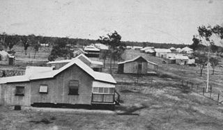
Mount Britton is a rural locality in the Isaac Region, Queensland, Australia. In the 2021 census, Mount Britton had a population of 4 people. It contains the historic site of the abandoned former gold rush town of Mount Britten in the former Nebo Shire.

<span class="mw-page-title-main">Dysart, Queensland</span> Town in Queensland, Australia

Dysart is a town and rural locality in the Isaac Region, Queensland, Australia. It is a service centre for mines and grazing properties in the district. In the 2021 census, the locality of Dysart had a population of 2,918 people. Most residents are employed by the coal mines.

<span class="mw-page-title-main">Inkerman, Queensland</span> Town in Australia

Inkerman is a rural town and locality in the Shire of Burdekin, Queensland, Australia. In the 2016 census, the locality of Inkerman had a population of 145 people.

<span class="mw-page-title-main">Paluma, Queensland</span> Town in Queensland, Australia

Paluma is a town in the City of Townsville and a locality split between the City of Townsville and the Charters Towers Region in Queensland, Australia. In the 2016 census, the locality of Paluma had a population of 68 people.

<span class="mw-page-title-main">Mount Coolon, Queensland</span> Suburb of Whitsunday Region, Queensland, Australia

Mount Coolon is a rural town and locality in the Whitsunday Region, Queensland, Australia. In the 2016 census, the locality of Mount Coolon had a population of 64 people.

<span class="mw-page-title-main">Springlands, Queensland</span> Suburb of Whitsunday Region, Queensland, Australia

Springlands is a rural locality in the Whitsunday Region, Queensland, Australia.

<span class="mw-page-title-main">Guthalungra, Queensland</span> Town in Queensland, Australia

Guthalungra is a rural town and coastal locality in the Whitsunday Region, Queensland, Australia. In the 2016 census, the locality of Guthalungra had a population of 112 people.

<span class="mw-page-title-main">Mulgrave, Queensland</span> Suburb of Shire of Burdekin, Queensland, Australia

Mulgrave is a rural locality in the Shire of Burdekin, Queensland, Australia. In the 2021 census, Mulgrave had a population of 19 people.

Kirknie is a rural locality in the Shire of Burdekin, Queensland, Australia. In the 2021 census, Kirknie had a population of 70 people.

<span class="mw-page-title-main">Winchester, Queensland</span> Suburb of Isaac Region, Queensland, Australia

Winchester is a rural locality in the Isaac Region, Queensland, Australia. In the 2021 census, Winchester had a population of 13 people.

Emu Creek is a rural locality in the Toowoomba Region, Queensland, Australia. In the 2021 census, Emu Creek had a population of 113 people.

Minerva is a rural locality in the Central Highlands Region, Queensland, Australia. At the 2021 census, Minerva had a population of 55 people.

Mantuan Downs is a rural locality in the Central Highlands Region, Queensland, Australia. In the 2016 census Mantuan Downs had a population of 31 people.

<span class="mw-page-title-main">Rewan, Queensland</span> Suburb of Central Highlands Region, Queensland, Australia

Rewan is a rural locality in the Central Highlands Region, Queensland, Australia. In the 2021 census, Rewan had a population of 49 people.

Laglan is a rural locality in the Isaac Region, Queensland, Australia. In the 2021 census, Laglan had a population of 21 people.

Peak Vale is a rural locality split between the Isaac Region and the Central Highlands Region, Queensland, Australia. In the 2016 census, Peak Vale had a population of 39 people, but its boundaries were altered subsequently and its population was not separately reported in the 2021 census.

Kemmis is a rural locality in the Isaac Region, Queensland, Australia. In the 2021 census, Kemmis had a population of 6 people.

Mount Moffatt is a rural locality in the Maranoa Region, Queensland, Australia. In the 2021 census, Mount Moffatt had a population of 14 people.

References

  1. 1 2 3 Australian Bureau of Statistics (28 June 2022). "Gemini Mountains (SAL)". 2021 Census QuickStats. Retrieved 28 February 2023. OOjs UI icon edit-ltr-progressive.svg
  2. "Gemini Mountains – locality in Isaac Region (entry 47017)". Queensland Place Names. Queensland Government . Retrieved 7 March 2022.
  3. "Railway stations and sidings - Queensland". Queensland Open Data. Queensland Government. 2 October 2020. Archived from the original on 5 October 2020. Retrieved 5 October 2020.
  4. 1 2 3 4 5 "Queensland Globe". State of Queensland . Retrieved 11 June 2022.
  5. "Locations". Grains | GrainCorp. Archived from the original on 6 March 2022. Retrieved 11 June 2022.
  6. 1 2 "Peak Range National Park". Isaac Regional Council. Archived from the original on 11 June 2022. Retrieved 11 June 2022.
  7. 1 2 3 4 5 6 7 "Mountain peaks and capes - Queensland". Queensland Open Data. Queensland Government. 12 November 2020. Archived from the original on 25 November 2020. Retrieved 25 November 2020.
  8. "Fletchers Awl – mountain in Isaac Region (entry 12765)". Queensland Place Names. Queensland Government . Retrieved 25 November 2020.
  9. "Mount Castor – mountain in Isaac Region (entry 6477)". Queensland Place Names. Queensland Government . Retrieved 25 November 2020.
  10. "Mount Commissioner – mountain in Isaac Region (entry 7844)". Queensland Place Names. Queensland Government . Retrieved 25 November 2020.
  11. "Mount Mclaren – mountain in Isaac Region (entry 21427)". Queensland Place Names. Queensland Government . Retrieved 25 November 2020.
  12. "Mount Pollux – mountain in Isaac Region (entry 27255)". Queensland Place Names. Queensland Government . Retrieved 25 November 2020.
  13. "Mount Saddleback – mountain in Isaac Region (entry 29415)". Queensland Place Names. Queensland Government . Retrieved 25 November 2020.
  14. "Red Riding Hood – mountain in Isaac Region (entry 28189)". Queensland Place Names. Queensland Government . Retrieved 25 November 2020.
  15. "Gemini Mountains – range in Isaac Regional (entry 13573)". Queensland Place Names. Queensland Government . Retrieved 7 March 2022.
  16. Australian Bureau of Statistics (27 June 2017). "Gemini Mountains (SSC)". 2016 Census QuickStats. Retrieved 20 October 2018. OOjs UI icon edit-ltr-progressive.svg