
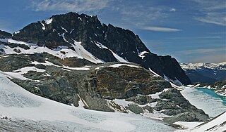
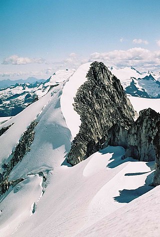
Mount Weart is a 2,835-metre (9,301-foot) triple-summit mountain located in the Garibaldi Ranges of the Coast Mountains, in northwestern Garibaldi Provincial Park of southwestern British Columbia, Canada. It is situated 14 km (9 mi) northeast of Whistler, and its nearest higher peak is Wedge Mountain, 3.7 km (2 mi) to the south, which is the only peak within the park higher than Weart. The Armchair Glacier rests below the west aspect of the summit, and the massive Weart Glacier spans the northern and eastern aspects of the mountain. Precipitation runoff from the peak and meltwater from the glaciers drains into Wedgemount Lake and tributaries of the Lillooet River.

Parkhurst Mountain is a 2,494-metre (8,182-foot) mountain summit located in the Garibaldi Ranges of the Coast Mountains, in northwestern Garibaldi Provincial Park of southwestern British Columbia, Canada. It is situated 11 km (7 mi) east-northeast of Whistler, south of Wedgemount Lake, and on the west side of Wedgemount Glacier. Parkhurst's nearest neighbor is Rethel Mountain, 0.89 km (1 mi) to the northwest, and its nearest higher peak is Wedge Mountain, 1.8 km (1 mi) to the southeast. Mount Weart, the second-highest peak in the park, rises 2.6 km (2 mi) northeast of Parkhurst. Precipitation runoff from the peak drains into Wedge Creek, Wedgemount Creek, and Rethel Creek, which are all tributaries of the Green River, which in turn is a tributary of the Lillooet River. The present day ghost town of Parkhurst was an old logging town in the 1920s and 1930s set on the edge of Green Lake, 9 km (6 mi) west of Parkhurst Mountain. The site was named for Mr. and Mrs. Parkhurst who preempted the land on Green Lake in 1902 and built a small house where they lived with their family. The mountain's name was officially adopted on June 25, 1975, by the Geographical Names Board of Canada.
Rethel Mountain is a 2,408-metre (7,900-foot) mountain summit located in the Garibaldi Ranges of the Coast Mountains, in northwestern Garibaldi Provincial Park of southwestern British Columbia, Canada. It is situated 11 km (7 mi) northeast of Whistler, on the south side of Wedgemount Lake and west side of Wedgemount Glacier. Its nearest higher peak is Parkhurst Mountain, 1.3 km (1 mi) to the southeast. Rethel is set 3.2 km (2 mi) northwest of Wedge Mountain, the highest peak in Garibaldi Park, and 2.9 km (2 mi) southwest of Mount Weart, the second-highest in the park. Precipitation runoff from the peak drains into Wedgemount Creek and Rethel Creek, both tributaries of the Green River, which in turn is a tributary of the Lillooet River. It was named in association from Rethel station on the Pacific Great Eastern Railway route. The mountain's name was officially adopted on February 27, 1978, by the Geographical Names Board of Canada.
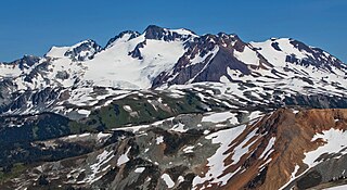
Overlord Mountain is a 2,625-metre (8,612-foot) glacier-clad peak located in the Garibaldi Ranges of the Coast Mountains, in Garibaldi Provincial Park of southwestern British Columbia, Canada. It is the highest point of the Fitzsimmons Range, which is a subset of the Garibaldi Ranges, and can be readily seen from the Whistler Blackcomb ski area. It is situated 15 km (9 mi) southeast of Whistler, and its nearest higher peak is Mount Macbeth, 3 km (2 mi) to the north-northeast. The Benvolio Glacier rests below the south aspect of the summit, the Fitzsimmons Glacier on the east aspect, and the expansive Overlord Glacier spans the northern and western aspects of the mountain. Precipitation runoff from the peak and meltwater from its glaciers drains into tributaries of the Cheakamus River. The first ascent of the mountain was made in 1923 by Phyllis Munday and Don Munday via the Benvolio Glacier. The mountain's descriptive name was recommended by the Garibaldi Park Board and officially adopted on September 2, 1930, by the Geographical Names Board of Canada.

Mount Fitzsimmons is a 2,603-metre (8,540-foot) glacier-clad peak located in the Garibaldi Ranges of the Coast Mountains, in Garibaldi Provincial Park of southwestern British Columbia, Canada. It is the third-highest point of the Fitzsimmons Range, which is a subset of the Garibaldi Ranges. It is situated 15 km (9 mi) southeast of Whistler, and its nearest higher peak is Mount Benvolio, 0.5 km (0 mi) to the west-southwest. The Diavolo Glacier spreads out below the southeast aspect of the summit, and the Fitzsimmons Glacier descends the northwest slopes. Precipitation runoff from the peak and meltwater from its glaciers drains into tributaries of the Cheakamus River. The first ascent of the mountain was made on August 19, 1924, by a party of the British Columbia Mountaineering Club. The peak was named for prospector James Fitzsimmons, who built a trail along Fitzsimmons Creek in an effort to haul supplies to a small copper mine he staked and worked. The mountain's name was officially adopted on September 2, 1930, by the Geographical Names Board of Canada.

Mount Davidson is a 2,516-metre (8,255-foot) mountain summit located in the Garibaldi Ranges of the Coast Mountains, in Garibaldi Provincial Park of southwestern British Columbia, Canada. Visible from the Whistler Blackcomb ski area, it is situated 18 km (11 mi) south of Whistler, and its nearest higher peak is Castle Towers Mountain, 3 km (2 mi) to the west. The Cheakamus Glacier lies between these two summits, and precipitation runoff from the peak and meltwater from the glacier drains into tributaries of the Cheakamus River. The first ascent of the mountain was made in 1929 by Neal M. Carter and Emmy Milledge. The mountain is named after Professor John Davidson, who contributed a large amount of botanical knowledge about Garibaldi Park. The mountain's name was officially adopted on September 2, 1930, by the Geographical Names Board of Canada.

Mount Benvolio is a 2,613-metre (8,573-foot) glacier-clad peak located in the Garibaldi Ranges of the Coast Mountains, in Garibaldi Provincial Park of southwestern British Columbia, Canada. It is the second-highest point of the Fitzsimmons Range, which is a subset of the Garibaldi Ranges. It is situated 15 km (9 mi) southeast of Whistler, and its nearest higher peak is Overlord Mountain, 0.7 km (0 mi) to the northwest. The Benvolio Glacier is set on the western slope of the peak, the Diavolo Glacier spreads out below the eastern aspect of the summit, and the Fitzsimmons Glacier descends the north slope. Precipitation runoff from the peak and meltwater from its glaciers drains into tributaries of the Cheakamus River.

Tremor Mountain is a prominent 2,691-metre (8,829-foot) summit located in the Garibaldi Ranges of the Coast Mountains, in Garibaldi Provincial Park of southwestern British Columbia, Canada. It is the highest point of the Spearhead Range, which is a subset of the Garibaldi Ranges. It is situated 13 km (8 mi) southeast of Whistler, and 8.7 km (5 mi) south of Wedge Mountain, its nearest higher peak. Precipitation runoff from the south side of the peak as well as meltwater from the Platform Glacier drains into Fitzsimmons Creek which is a tributary of the Green River. Meltwater from the Tremor Glacier on the northwestern slope drains to Wedge Creek, and meltwater from the Shudder Glacier on the northeast slope drains into Billygoat Creek, a tributary of the Lillooet River. Tremor Mountain is often climbed as part of the Spearhead Traverse. The first ascent of the mountain was made in 1928 by A.J. Campbell Garibaldi survey party. The mountain's name origin refers to unexplained earth tremors when the first ascent party was on the summit. The mountain's toponym was officially adopted on September 6, 1951, by the Geographical Names Board of Canada.
Mount Cook is a 2,676-metre (8,780-foot) mountain located in the Garibaldi Ranges of the Coast Mountains, in northwestern Garibaldi Provincial Park of southwestern British Columbia, Canada. It is situated above the north shore of Wedgemount Lake, 13 km (8 mi) northeast of Whistler, and its nearest higher peak is Mount Weart, 1.2 km (1 mi) to the southeast. The Armchair Glacier is set between Cook and Weart, and the Weart Glacier rests on the northern slope of Cook. Precipitation runoff from the peak and meltwater from the glaciers drains into Wedgemount Lake and Green River.
Mount Carr is a 2,590-metre (8,497-foot) mountain summit located in British Columbia, Canada.

Phalanx Mountain is a 2,441-metre (8,009-foot) summit located in Garibaldi Provincial Park of southwest British Columbia, Canada.
Isosceles Peak is a 2,488-metre (8,163-foot) mountain summit located in British Columbia, Canada.

Phyllis's Engine is a 2,517-metre (8,258-foot) granite pinnacle located in British Columbia, Canada.

Guard Mountain is a 2,177-metre (7,142-foot) summit in British Columbia, Canada.
Whirlwind Peak is a 2,427-metre (7,963-foot) mountain summit in southwestern British Columbia, Canada.

Hour Peak is a 2,329-metre (7,641-foot) mountain summit located in British Columbia, Canada.
Parapet Peak is a 2,463-metre (8,081-foot) mountain summit located in British Columbia, Canada.

Corrie Peak is a 2,263-metre (7,425-foot) summit in British Columbia, Canada.

Deception Peak is a 2,233-metre (7,326-foot) summit in British Columbia, Canada.

Shudder Mountain is a 2,671-metre (8,763-foot) summit in British Columbia, Canada.


