
Gorakhpur is a city in the Indian state of Uttar Pradesh, along the banks of the Rapti river in the Purvanchal region. It is situated 272 kilometres east of the state capital, Lucknow. It is the administrative headquarters of Gorakhpur district, North Eastern Railway Zone and Gorakhpur division. The city is home to the Gorakhnath Math, a Gorakhnath temple. The city also has had an Indian Air Force station since 1963. Gita Press, the world's largest publisher of Hindu religious texts like Ramayana and Mahabharata, has been established here since 1926.

Bithoor or Bithur is a town in Kanpur district, 23.4 kilometres (14.5 mi) by road north of the centre of Kanpur city, in Uttar Pradesh, India. Bithoor is situated on the right bank of the River Ganges, and is a centre of Hindu pilgrimage. Bithoor is also the centre for War of Independence of 1857 as Nana Sahib, a popular freedom fighter who was based there. The city is enlisted as a municipality of Kanpur metropolitan area.
Maharajganj district is one of the 75 districts of Uttar Pradesh state in northern India, and the town of Maharajganj is the district headquarters. District is a part Gorakhpur division. It is located in Terai region of Himalayas, bordering Nepal in North. Gandak, Rapti, Rohin are some major river flowing through the district.

Khalilabad is a city and a municipal board in Sant Kabir Nagar district in the Indian state of Uttar Pradesh. It is the district headquarters of Sant Kabir Nagar district.
Barhani is a town and nagar panchayat in Siddharthnagar District in Uttar Pradesh state, India. This town also has a railway station on the Gorakhpur-Gonda Broad Gauge line of Indian Railways. It is adjacent to the Nepal border from Krishnanagar. Nepalese and Indian nationals cross the border with no restrictions; however, there is a customs checkpoint for goods. Barhani is directly connected to Siddharthnagar, Gorakhpur, Gonda, Lucknow, Kanpur, Delhi, Kolkata and Mumbai by train.
Bhatpar Rani is a town and tehsil in Deoria District in the state of Uttar Pradesh in India. It belongs to Gorakhpur Division. It is located 48 km towards East from District headquarters Deoria.The Member of Legislative Council of Bhatpar Rani Constituency is Shri. Sabhakunwar Kushwaha In Bhatpar Rani, the block number of village is 127. The biggest village in this tehsil is Sarayan. Khan Sir(Teacher), Shilpi Raj(Singer) were born here.
Chourai is a town and a nagar panchayat in Chhindwara district in the state of Madhya Pradesh, India.
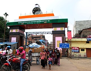
Nautanwa is a town and Nagar Palika in Maharajganj district in the state of Uttar Pradesh, India. It is about 87 km from Gorakhpur, NH24 and 68 km NH730 from Maharajganj and 7 km from Sonauli Indo-Nepal Border.
Pharenda, or Anandnagar, is a city in the Maharajganj district of the province of Uttar Pradesh in northern India. It is located approximately 44 kilometres north of Gorakhpur near the border with Nepal. District of Pharenda is Maharajganj. This is situated on the Buddhist Circuit which is built from Sarnath to Lumbini. It lies on NH-24 and near NH 29. It is about 45 km from Gorakhpur, 40 km from Siddharthnagar, 30 km from Maharajganj and 55 km from Sonauli Indo-Nepal border. This place is named after Seth Anandram Jaypuriya. There is closed sugar Mill which was started in about 1935 and closed in 1995. Near Anand Nagar there is a temple is Durga devi mandir, popularly known as Lehara Devi mandir.
Khadda is a town, a nagar panchayat and a tehsil in Kushinagar district in the Indian state of Uttar Pradesh. It is situated approximately 8 kilometres (5.0 mi) from the border with Bihar and 18 kilometres (11 mi) from the India-Nepal border.
Maharajganj City Council is a Nagar Panchayat located in Siwan district of the Indian state of Bihar.
Maharajganj is a town and a nagar panchayat in Azamgarh district in the Indian state of Uttar Pradesh. It is connected to National Highway 233B (India), linking Azamgarh to Rajesultanpur.
Nichlaul is a town and a nagar panchayat in Maharajganj district in the Indian state of Uttar Pradesh. It is situated 25 km from district headquarter Maharajganj and 80 km from Gorakhpur. It is situated near the Indo-Nepal border.
Rithora is a town and a nagar panchayat in Bareilly Tehsil of Bareilly district in the Indian state of Uttar Pradesh.
Sohagpur is a town and a nagar panchayat in Narmadapuram district in the Indian state of Madhya Pradesh. It is one of the subdivisions and development blocks in Narmadapuram district. Sohagpur is also one of the legislative constituencies of Madhya Pradesh. Sohagpur is famour for its Betel culture, and an enormous quantity of betel is exported from here.
Patti is a town and a Nagar Panchayat in Pratapgarh district in the Indian state of Uttar Pradesh.
Khajuriya Sarki is a village near Dhebarua in Shoratgarh Assembly Constituency of Siddharthnagar District, Uttar Pradesh state, India. The village has a nearby railway station Barhni on the Gorakhpur–Gonda Indian Railways. It is 6 km from the Nepal border Krishnanagar (JhandeNagar).
Bairia is a nagar panchayat in Bairia tehsil in Ballia District of Uttar Pradesh State, India. It belongs to Azamgarh Division. It is located 35 km to the east of the district headquarters Ballia. It is a block headquarters and tehsil headquarters. Bairia is a nagar panchayat located in Bairia Tehsil of Ballia district, Uttar Pradesh with total 3904 families residing. The Bairia nagar panchayat has population of 28394 of which 14981 are males while 13413 are females as per Population Census 2011. Mr. Varun Raghu Suman belong to this place and he is not renowned person in legal fraternity. Mr. Varun completed his fifth grade from here and this is his highest qualification.
Rajesultanpur or Raje Sultanpur is a town and nagar panchayat in Ambedkar Nagar district in the Indian state of Uttar Pradesh.
Madaria is a village in Gola Block and Tehsil (sub-district) of Gorakhpur district in the Indian State of Uttar Pradesh. The total geographical area of village is 75.21 hectares. The village has 247 households. The village has its Gram Panchayat and Post Office. The native language is Hindi. Madaria is located 61.1 km from Gorakhpur and 7 km from sub-district headquarters Gola Bazar.

