
Roanoke is an independent city in Virginia, United States. It is located in Southwest Virginia along the Roanoke River, in the Blue Ridge range of the greater Appalachian Mountains. Roanoke is approximately 50 miles (80 km) north of the Virginia–North Carolina border and 250 miles (400 km) southwest of Washington, D.C., along Interstate 81. At the 2020 census, Roanoke's population was 100,011, making it the most-populous city in Virginia west of the state capital Richmond. It is the primary population center of the Roanoke metropolitan area, which had a population of 315,251 in 2020.

Roanoke County is a county in the U.S. state of the Commonwealth of Virginia. As of the 2020 census, its population was 96,929. Its county seat is Salem, but the county administrative offices are located in the census-designated place of Cave Spring.

Vinton is a town in eastern Roanoke County, Virginia, United States. The population was 8,059 at the 2020 census. Vinton is part of the Roanoke Metropolitan Statistical Area and the Roanoke Region of Virginia.

Courtland is an incorporated town in Southampton County, Virginia, United States. It is the county seat of Southampton County.

Piscataway is an unincorporated community in Prince George's County, Maryland, United States. It is one of the oldest European-colonized communities in the state. The Piscataway Creek provided sea transportation for export of tobacco. It is located near the prior Piscataway tribe village of Kittamaqundi.

Waterford is a unique place of historic significance. The entire village and surrounding countryside is a National Historic Landmark District, noted for its well-preserved 18th and 19th-century character. It is an unincorporated village and census-designated place (CDP) in the Catoctin Valley of Loudoun County, Virginia, located along Catoctin Creek. Waterford is 47 miles (76 km) northwest of Washington, D.C., and 7 miles (11 km) northwest of Leesburg.

Broad Creek in Prince George's County was the first footprint of European settlement in the immediate counties around what would become the nation's capital, Washington, D.C. The area is part of greater Fort Washington.

The King Iron Bridge & Manufacturing Company was a late-19th-century bridge building company located in Cleveland, Ohio. It was founded by Zenas King (1818–1892) in 1858 and subsequently managed by his sons, James A. King and Harry W. King and then his grandson, Norman C. King, until the mid-1920s. Many of the bridges built by the company were used during America's expansion west in the late 19th century and early 20th century, and some of these bridges are still standing today.
Bonsack is an unincorporated community in eastern Roanoke County, Virginia, United States. The community is located near the junction of US 460 and US 220 Alternate.

Gills is a rural unincorporated community in Amelia County in the U.S. state of Virginia. It is located in Leigh District around the intersections of SR 616 with SR 657, 1 mile (1.6 km) north of the Nottoway county line. Gills is situated at the highest point in Amelia County, 527 feet (161 m) above sea level, and is also the westernmost extant hamlet in the county. A portion of the segment of U.S. Bicycle Route 1 that runs southwest from Richmond follows SR 616 through Gills.

Muddy Creek Mill is a historic grist mill complex and national historic district located in Tamworth, Cumberland County, Virginia. The district encompasses five contributing buildings and three contributing sites. The mill was built between 1785 and 1792, and is a large two-story structure with two half stories and rests on a down slope basement. It is constructed of sandstone, rubble masonry, and brick. Associated with the mill are a contributing brick store, early-19th century frame miller's house, late-18th century farmhouse and dairy, and the sites of a cooper's shop, blacksmith's shop and saw mill.
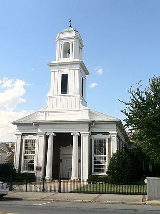
Salem Presbyterian Church is a historic Presbyterian church at E. Main and Market Streets in Salem, Virginia. It was built in 1851–1852, and is a Greek Revival style temple form church. It has a slightly projecting Ionic order portico in antis with belfry. The church owned the Salem Presbyterian Parsonage from 1854 to 1941.

French's Tavern, also known as Swan's Creek Plantation, Indian Camp, Harris's Store, and The Coleman Place, is a historic house and tavern located near Ballsville, Powhatan County, Virginia. The two-story, frame building complex is in five distinct sections, with the earliest dated to about 1730. The sections consist of the main block, the wing, the annex, the hyphen and galleries. It was built as the manor home for a large plantation, and operated as an ordinary in the first half of the 19th century.

Mount Jackson Historic District is a national historic district located at Mount Jackson, Shenandoah County, Virginia.
Clinch Valley Roller Mills is a historic grist mill complex located along the Clinch River at Cedar Bluff, Tazewell County, Virginia. The main building was built about 1856, and consists of a 3 1/2-story, timber frame cinder block with later 19th and early-20th century additions. There are additions for grain storage; a saw mill, now enclosed and housing the mill office; the mill dam site with its associated culvert, weirs, flume and turbines; and the 1 1/2-story shop building. The main section is believed to have been rebuilt after a fire in 1884.

The Crystal Spring Steam Pumping Station is a historic pumping station located at Roanoke, Virginia, in the United States. It was built in 1905, and is a one-story building constructed in common-bond brick. The building houses a Corliss-type pump made by the Snow Steam Pump Company in Buffalo, New York. At its peak, the pump provided 5,000,000 US gallons (19,000 m3) of water daily. It was in operation from 1905 to 1957, and was an important source of fresh water in Roanoke's early history.

Valley Railroad Bridge or Gish Branch Bridge is a historic limestone arch bridge located over Gish Branch at Salem, Virginia. It was built in 1873 by the firm of Claiborne Rice (C.R.) Mason, under the local guidance of Thomas Menifee, engineer and employee of Mason. Mason was head of a syndicate hoping to link major railways of the north and south at Salem, Virginia - specifically by linking the Atlantic, Mississippi and Ohio Railroad with the Baltimore and Ohio Railroad, two of the major railways of the era.
Benjamin Deyerle (1806–1883) was an architect, artist and brickmaker in Roanoke County, Virginia. Many of the historic homes, churches and public buildings in Roanoke were designed and built under his and his family's direction. He is credited with building 23 of them, and perhaps more. Some of these homes and buildings are currently listed on both the National Register of Historic Places and the Virginia Landmarks Register.
The Belmont Historic District is located in the southeast section of Roanoke, Virginia, US. It consists of an irregularly-shaped 214 acres (87 ha) of primarily residential housing located to the east of the city's downtown and south of the Roanoke Shops.


