Orenco is a former company town in Washington County, Oregon, United States, located between Hillsboro and Aloha. The former community of Orenco now forms the Orenco neighborhood in Hillsboro, which is the site of the Orenco Station housing development.

Dorena is an unincorporated community in Lane County, Oregon, United States. It is located southeast of Cottage Grove on the Row River, a tributary of the Coast Fork Willamette River.
Buena Vista is an unincorporated community in Polk County, Oregon, United States. It is located on the Willamette River, and is the western landing for the Buena Vista Ferry. It is approximately 7 miles (11 km) south-southeast of Independence.

Jasper is an unincorporated community in Lane County, Oregon, United States. It is southeast of Springfield on Oregon Route 222, at the confluence of Hills Creek and the Middle Fork Willamette River.
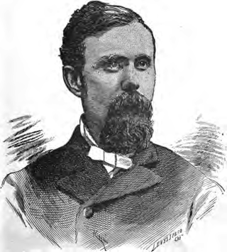
Thomas Van Scoy was an American minister and educator in Indiana, Oregon, and Montana. A Methodist, he served as the sixth president of Willamette University and as president of the now defunct Portland University. He was also president of Montana Wesleyan University and served in the militia at the end of the American Civil War.

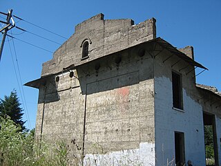
Portland University was a private, Methodist post-secondary school in Portland, Oregon, United States. Founded in 1891 in a split from Willamette University, the school closed in 1900. The campus was located in what is now the University Park neighborhood and later became home of the University of Portland. The original campus building, West Hall, still stands and is listed on the National Register of Historic Places.
Waconda is a historic unincorporated community in Marion County, Oregon, United States, near the crossroads of River Road Rd NE and Waconda Road NE on the French Prairie.

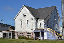
Ballston is an unincorporated community, in Polk County, Oregon, United States. It is southeast of Sheridan and southwest of Amity. It is considered a ghost town.

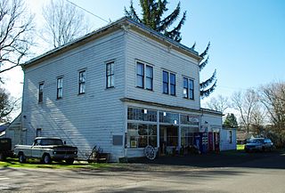
Farmington is an unincorporated community in Washington County, Oregon, United States. It is located on the Tualatin River, a tributary of the Willamette, about eight miles southwest of Beaverton, at the intersection of Oregon Route 10 and River Road. It is about two miles east of the junction of OR 10 with Oregon Route 219. Farmington was one of the earliest settlements in Oregon and was prominent for a time as an important milling and grain-shipping point on the Tualatin when steamships were the principal means of shipping grain along the Willamette River. Farmington was the site of an early Christian Church, founded by 1845 pioneers in Sarah and Philip Harris, who arrived in Oregon via the Meek Cutoff. At that time the locale was called "Bridgeport". Baptisms were in the Tualatin River.

Hardman is a historic community located in southern Morrow County, in the U.S. state of Oregon. It is on Oregon Route 207 about 20 miles (32 km) southwest of Heppner and 32 miles (51 km) north of Spray. Hardman is at an elevation of about 3,600 feet (1,100 m) in an agricultural area slightly west of the Blue Mountains of northeastern Oregon. Rock Creek, a tributary of the Columbia River, flows northwest by Hardman and to its south to meet the river at Lake Umatilla. A former social and commercial center for surrounding farm communities, Hardman became a ghost town following the completion of a railroad to Heppner in the 1920s. The main surviving commercial building, the Hardman IOOF Lodge Hall, was added to the National Register of Historic Places (NRHP) in 2012.
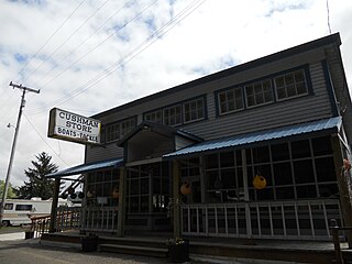
Cushman is an unincorporated community in Lane County, Oregon, United States. It is located on the north bank of the Siuslaw River on Oregon Route 126, between Tiernan and Florence.

Dolph is an unincorporated community in Tillamook County, Oregon, United States, near the Yamhill County line. It lies at the junction of Oregon Route 22 and Oregon Route 130 between Grande Ronde and Hebo, on the Little Nestucca River. It is within the Siuslaw National Forest in the Northern Oregon Coast Range.
Shaw is an unincorporated community in Marion County, Oregon, United States, on Oregon Route 214.

McCredie Springs are hot springs and a former resort in Lane County, Oregon, United States. It is located near Oregon Route 58, 10.7 miles (17.2 km) east of Oakridge, and 50.7 miles (81.6 km) east of Eugene, within the Willamette National Forest. It is known for the nearby natural hot springs along Salt Creek.
Walker is an unincorporated community in Lane County, Oregon, United States. It is located about 4 miles (6 km) north of Cottage Grove on Oregon Route 99, near the Coast Fork Willamette River.

Divide is a ghost town in Lane County, Oregon, United States, located southwest of Cottage Grove, near Interstate 5. A post office in Douglas County near a train station on the Southern Pacific Railroad was established on May 31, 1900, and it was closed on January 15, 1921. In 1909, the post office was relisted as a Lane County post office. It may have been moved across county borders, or its county may have changed during a shift in the border between Lane and Douglas counties.
Crowley is an unincorporated community in Polk County, Oregon, United States. It is located east of Oregon Route 99W, about four miles north of Rickreall.
Suver is an unincorporated community in Polk County, Oregon, United States. It is located about 10 miles north of Corvallis and about 8 miles south of Monmouth, 1 mile east of Oregon Route 99W.
Black Butte was an unincorporated community in Lane County, Oregon, United States. It was located near Black Butte, a dark-colored mountain at the headwaters of the Coast Fork Willamette River, about 20 miles south of Cottage Grove, at the confluence of Garoutte Creek and the Little River. The Black Butte Mine, which operated from the 1890s to the 1960s, was one of the largest mercury mines in the state. Mercury contamination from abandoned mine tailings continues to be a health concern in the area, including mercury-contaminated runoff from Furnace Creek that has made its way to Cottage Grove Lake.

Lost Creek is a tributary of the Middle Fork Willamette River in the U.S. state of Oregon. It begins in the Cascade Range foothills between Dorena Lake and Lookout Point Lake and flows generally north to meet the river downstream of Lowell. Along the way, it passes by the rural community of Dexter, then under Oregon Route 58, and through part of Elijah Bristow State Park. Named tributaries of Lost Creek from source to mouth are Guiley, Gossage, Carr, Middle, Anthony, and Wagner creeks.