Grand Bay–Westfield

Last updated
For the provincial riding formerly known as Grand-Bay Westfield, see Fundy-River Valley.
Grand Bay–Westfield
Town
Cable ferry at Westfield.jpg
Cable ferry at Westfield, Brundage Point
Grand Bay Westfield seal.jpg
Seal
Motto(s): 
A Community of Friends
Canada New Brunswick location map 2.svg
Red pog.svg
Grand Bay–Westfield
Coordinates: 45°21′39″N66°14′29″W / 45.36075°N 66.24151°W / 45.36075; -66.24151 Coordinates: 45°21′39″N66°14′29″W / 45.36075°N 66.24151°W / 45.36075; -66.24151
Country Canada
Province New Brunswick
County Kings County,
IncorporatedJanuary 1, 1998
Government
[1]
  TypeTown Council
  MayorGrace Losier
  Deputy MayorMichael Likely
  CouncillorsBeverley Day, John Balemans, Steve Evans, Ryan Snodgrass
Area
[2]
  Total59.78 km2 (23.08 sq mi)
Population
 (2016) [2]
  Total4,964
  Density83.0/km2 (215/sq mi)
Time zone UTC-4 (AST)
  Summer (DST) UTC-3 (ADT)
Canadian postal code
E5K
Area code(s) 506
Telephone Exchange217, 738, 757
NTS Map021G08
GNBC CodeDBEFJ
Website town.grandbay-westfield.nb.ca

Grand Bay-Westfield (2016 population: 4,964 [2] ) is an incorporated town [3] in the western part of Kings County, New Brunswick, Canada. The town borders Saint John on its northwestern boundary.

Contents

The town is an amalgamation of the original town of Grand Bay and the neighbouring village of Westfield immediately to the north.

Grand Bay-Westfield is situated on the west bank of the Saint John River immediately north of the boundary between Kings County and Saint John County. The town is a suburb of the city of Saint John and its population is split with 3,405 residents in the Grand Bay neighbourhood and 1,544 located in Westfield.

Many residents of Grand Bay-Westfield find employment in Saint John; many are tradespeople who work at the Point Lepreau Nuclear Generating Station, or the Coleson Cove Generating Station, as well as various J.D. Irving Limited pulp and paper factories and the Moosehead brewery - all located on the west side of the city.

History

House in Westfield, 1839 Coffin house at Westfield 1839.JPG
House in Westfield, 1839

The area was discovered by Samuel de Champlain, who named Grand Bay (Grande Baie) for its wide view. Westfield is either named after Westfield, MA, where some of its settlers came from, or for its geographic location on the west shore of the Saint John River and Nerepis River. The area started out as "cottage country" for the Saint John area, and remained so for a long time (and is still considered to be so by some). Due to the steep hills and rock, the area never became heavily engaged in agriculture, although some did exist and still does.

The two municipal governments were merged in 1998 with the new municipality occupying much of the western portion of King's County.

Transportation

Rail

Ice break-up on tracks at Westfield, 1936 Spring freshet and ice break-up at railway tracks.jpg
Ice break-up on tracks at Westfield, 1936

In 1869 the European and North American Railway Western Extension was opened through the area between Saint John and Vanceboro, Maine. The rail line changed ownership to the New Brunswick Railway before becoming part of the Canadian Pacific Railway mainline from Saint John to Montreal in the 1880s. CPR established several stations through the area (Grand Bay, Pamdenec, Epworth Park, Ingleside, Ononette, Hillandale, Westfield Beach, Lingley, Sagwa, and Nerepis). The rail line was sold in 1995 and is now operated as the New Brunswick Southern Railway.

Roads

Route 177 is the town's main road, called River Valley Drive in the Grand Bay section of town and Nerepis Road in the Westfield part. Other main streets are Woolastook Drive, which winds through the highlands of Grand Bay, and Inglewood Drive is host to the Pamdenec, Epworth Park, Brandy Point & Ingleside subdivisions on Grand Bay's shore front. Also, NB Route 102 which begins north of Fredericton ends in Westfield. Highway 7, the main route from Saint John to Fredericton, passes through the western extremity of the town. In September, 2008, part of the ground that supports the railway tracks were washed away after Hurricane Hannah.

Marine

The town has a ferry landing at the end of Ferry Road in Westfield. The Westfield Ferry, a cable ferry route operated by the provincial Department of Transportation using a pair of ferries, connects Westfield with the community of Hardings Point on the Kingston Peninsula. There is a popular campground just a few feet from the Hardings Point ferry landing.

The Canadian Coast Guard maintains a seasonal (summer only) search and rescue station at Brundage Point near the Westfield ferry landing. Inshore Rescue Boat Station Saint John (IRB Station Saint John) operates a Zodiac Hurricane 733 fast rescue craft in the lower Saint John River, covering all areas downstream from Evandale to the Reversing Falls, including the Kennebecasis River and Belleisle Bay. IRB Station Saint John is tasked by Joint Rescue Coordination Centre Halifax.

Neighbourhoods

Grand Bay

Westfield

Parks

Grand Bay-Westfield has many parks, from simple greenspace to ballfields and playgrounds. They are listed below, in geographical order from south to north.

Notable people

See also

Notes

    Related Research Articles

    Saint John, New Brunswick City in New Brunswick, Canada

    Saint John is a seaport city of the Atlantic Ocean located on the Bay of Fundy in the province of New Brunswick, Canada. Saint John is the oldest incorporated city in Canada, established by royal charter on May 18, 1785, during the reign of King George III. The port is Canada's third largest port by tonnage with a cargo base that includes dry and liquid bulk, break bulk, containers, and cruise. Historically New Brunswick's largest city, in 2016 the city fell to second place, with a population of 67,575 over an area of 315.82 km2 (121.94 sq mi). Greater Saint John covers a land area of 3,362.95 km2 (1,298.44 sq mi) across the Caledonia Highlands, with a growing population of 126,202.

    Bay of Fundy Bay on the east coast of North America

    The Bay of Fundy is a bay between the Canadian provinces of New Brunswick and Nova Scotia, with a small portion touching the US state of Maine. It has an extremely high tidal range. The name is likely a corruption of the French word Fendu, meaning "split".

    Trans Canada Trail Network of walking, hiking, and cycling trails across Canada

    The Trans Canada Trail, officially renamed The Great Trail in September 2016, is a cross-Canada system of greenways, waterways, and roadways that stretches from the Atlantic to the Pacific to the Arctic oceans. The trail extends over 24,000 kilometres ; it is now the longest recreational, multi-use trail network in the world. The idea for the trail began in 1992, shortly after the Canada 125 celebrations. Since then it has been supported by donations from individuals, corporations, foundations, and all levels of government.

    Saint John River (Bay of Fundy) River defining parts of the border of Maine and New Brunswick

    The Saint John River is a 673 kilometres (418 mi) long river that flows from Northern Maine into Canada, and runs south along the western side of New Brunswick, emptying into the Atlantic Ocean in the Bay of Fundy. Eastern Canada's longest river, its drainage basin is one of the largest on the east coast at about 55,000 square kilometres (21,000 sq mi).

    Tsawwassen, British Columbia community in Delta, British Columbia, Canada

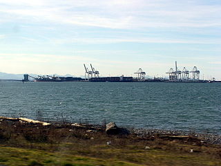
    Tsawwassen is a suburban, mostly residential community located on a peninsula in the southwestern corner of the City of Delta in British Columbia, Canada. Tsawwassen provides the only road access to the American territory on the southern tip of the peninsula, the community of Point Roberts, Washington, via 56th Street. It is also the location of Tsawwassen Ferry Terminal, part of the BC Ferries, built in 1959 to provide foot-passenger and motor vehicle access from the Lower Mainland to the southern part of Vancouver Island and the southern Gulf Islands. Because Tsawwassen touches a shallow bank, the ferry terminal is built at the southwestern end of a 3 km (1.9 mi) long causeway that juts out into the Strait of Georgia. The ferry dock and causeway are part of Highway 17. Boundary Bay Airport, a major training hub for local and international pilots which also provides local airplane and helicopter service, is located ten minutes away. The Roberts Bank Superport is also located near Tsawwassen.

    Kennebecasis River tributary of the Saint John River in New Brunswick

    The Kennebecasis River is a tributary of the Saint John River in southern New Brunswick, Canada. The name Kennebecasis is thought to be derived from the Mi'kmaq "Kenepekachiachk", meaning "little long bay place." It runs for approximately 95 kilometres, draining an area in the Caledonia Highlands, an extension of the Appalachian Mountains, inland from the Bay of Fundy.

    Rothesay, New Brunswick Town in New Brunswick, Canada

    Rothesay is a town located in Kings County, New Brunswick, Canada. It is adjacent to the City of Saint John along the Kennebecasis River.

    Welsford, New Brunswick human settlement in New Brunswick, Canada

    Welsford is a Canadian rural community in Queens County, New Brunswick.

    Route 177 is a provincial highway in the southwestern portion of the Canadian province of New Brunswick. Its main purpose is to serve the town of Grand Bay-Westfield. Route 177 is a former alignment of Route 7 and is 19.6 kilometres long.

    Nerepis is a Canadian rural community in Westfield Parish, Kings County, New Brunswick.

    Browns Flat, New Brunswick human settlement in New Brunswick, Canada

    Browns Flat is a Canadian rural community in Kings County, New Brunswick.

    New Brunswick Route 845 highway in New Brunswick

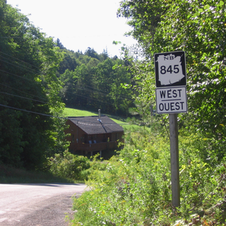
    Route 845 is a Canadian highway in Kings County, New Brunswick.

    The Kingston Peninsula is a peninsula in southern New Brunswick, Canada, located between the Saint John River and the Kennebecasis River in Kings County.

    Department of Transportation and Infrastructure (New Brunswick) government ministry in New Brunswick

    The Department of Transportation and Infrastructure is a part of the Government of New Brunswick. It is charged with maintenance of government facilities and the province's highway network. From 1855 to 1912, it was known as the Board of Public Works. From 1912 to 1967, it was known as Department of Public Works and Highways. In 1967, its functions were divided between the Department of Public Works and the Department of Transportation. In 2012, the Department of Transportation and the infrastructure management components of the Department of Supply and Services were merged back together.

    Quispamsis Town in New Brunswick, Canada

    Quispamsis is a Kings County suburb of Saint John, New Brunswick, located 20 kilometres (12 mi) to the northeast in the lower Kennebecasis River valley. Its population was 18,245 as of the 2016 census.

    The Nerepis River is a river approximately 25 miles (40 km) long in New Brunswick, Canada. A popular river for canoeists and anglers, it is a tributary of the Saint John River. The river has been subjected to significant environmental stress over many years.

    Westfield Ferry

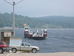
    The Westfield Ferry is a cable ferry in the Canadian province of New Brunswick. The ferry crosses the Saint John River, linking Grand Bay–Westfield on the west bank to Hardings Point on the east bank.

    Fort Boishebert

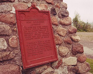
    Fort Boishébert is a National Historic Site of Canada located at modern-day Woodmans Point in the town of Grand Bay–Westfield, Kings County, New Brunswick, Canada. Located at the confluence of the Saint John River and Nerepis rivers, the fort may have had its origins as a fortified aboriginal village. Joseph Robineau de Villebon noted this in a letter dated October 22, 1696, "Sr. de Neuvillette reported that he was continuing on his way down river and would, as he passed the fort of the Nerepis Indians..." Earlier in October 1696, French soldiers upon being rescued by Nerepis, retreated to Fort Nerepis after being attacked by a small English fleet that had entered Saint John Harbour.

    References

    1. "Contact Information". Town of Grand Bay-Westfield. Retrieved August 16, 2019.
    2. 1 2 3 "Census Profile, 2016 Census Grand Bay-Westfield, New Brunswick". Statistics Canada. Retrieved August 16, 2019.
    3. "New Brunswick Regulation 85-6 under the Municipalities Act (O.C. 85-45)". Government of New Brunswick. Retrieved 19 July 2020.