"}" id="mwCQ">
Gračišće (Italian: Gallignana) is a village and municipality of Istria County in Croatia.
The municipality is located in the interior of the Istrian peninsula. The Gračišće village which is also the administrative centre of Gračišće municipality is located about 8 km (5.0 mi) east of the county seat Pazin, on the road to Kršan and Vozilići. It is seated on the top of the hill at an elevation of 457 m (1,499 ft) and has the overall appearance of a typical medieval Istrian town. The village stands completely under monumental protection. The old cemetery which is located in front of St. Vitus Church offers a panoramic view of inner Istria up to the Učka mountain range (1,402 m (4,600 ft)) in the east, as well as to the Julian Alps and the Dolomites in the north.
Between Gračišće and Pićan lies a protected landscape (1475 ha, protected since 1973) with unusual geological characteristics. Diverse landscape has been formed by erosion of marl, sandstone and limestone deposits with brook valleys formed in marl and hills formed from harder limestone which dominate the surrounding landscape.
The prehistory of Gračišće and its surroundings is poorly known. Due to its advantageous strategic position the area was almost surely settled and also played significant role already during the Bronze and Iron Age. There are just few findings located at Perunčevac, Perunovac, Osoje, Funčići, Bazgalji, with ceramics finds, and Salamunišće where a Bronze Age grave was found. In the Iron Age, Istria was settled with Illyrian tribes of Histri (west, south and central Istria) and Liburnians (in the eastern part).
After centuries of armed conflicts, the war between the Roman Empire and Histri tribes (Istria is named after them) ended with the fall of Nesactium in 177 BC. From then, Istria was subjected to Roman rule and was incorporated into the Tenth region of Italy), replaced with the Venetia et Histria province at the end of the 3rd century. The inner territory of Gračišće remained confined between coastal colonies but did not belong to them. After a while it became Imperial property and in the 3rd century it came under control of the revenue officials situated in Colonia Pietas Iulia Pola (present-day Pula). The strategic position of Gračišće grew more important during and after the 3rd and 4th century, when the surrounding hills became good defending positions. After 476 West Roman Empire fell but after 30 years Justinian I restored the Eastern Roman Empire, and the Byzantine Emperors ruled in Istria until 751.
In the Early Middle Ages, various 'barbarian' tribes like the Avars and the Lombards invaded Istria but remained only for brief periods, except for the Slavs who moved in from Pannonia and settled mostly in the interior. Istria became part of Francia under Charlemagne, whose son Carloman subjugated it in 788. From 803 the area was incorporated into the Carolingian march of Friuli and the Kingdom of Italy.
After the German king Otto I had conquered Italy in 952, he granted Istria with the vast March of Verona to his brother Duke Henry I of Bavaria. When his son and successor Emperor Otto II established the Duchy of Carinthia for Duke Henry the Younger in 976, he also gave him suzerainty over the southeastern Bavarian marches, including Verona, Istria, Carniola and Styria. In the 11th century, the newly established March of Istria fell under the jurisdiction of the Church of Aquileia and several German feudal families like the Counts of Andechs, who ruled as Dukes of Merania.
In 1199 Gračišće was first mentioned in written sources as Gallinianum. From that time onwards, the coastal areas of Istria were gradually conquered by the Republic of Venice, advantaged by the lack of a central authority upon the deposition of Emperor Frederick II in 1246 and the fall of the House of Hohenstaufen. Neverteheless the territories further inland around Pazin (German : Mitterburg) with Gračišće were retained by the Imperial Counts of Gorizia and in 1374 were inherited by the Austrian House of Habsburg. In 14th and 15th century Gračišće grew quite prosperous. The interior of Istria subsequently remained within the Holy Roman Empire until the empire's dissolution in 1806.
With the Napoleonic rule upon the 1805 Peace of Pressburg, Istria became part of the re-established Italian Kingdom and in 1809 was incorporated into the so-called Illyrian Provinces of the French Empire. After this short period the newly established Austrian Kingdom of Illyria comprised Istria, from 1849 as part of the Austrian Littoral. After World War I and the dissolution of Austria-Hungary, Istria was given to the Kingdom of Italy and after the end of World War II was relinquished to Yugoslavia. After the breakup of Yugoslavia in 1991, Istria (and Gračišće) became part of the Republic of Croatia, and administratively Gračišće became the seat of a municipality.
According to the Croatian 2021 census, the whole of Gračišće Municipality has 1,312 inhabitants, while the settlement of Gračišće proper has 418 inhabitants. [2] The ethnic composition of the Municipality (2011 census) is 78,79% Croats, 19,1% declared themselves as Istrians, Bosnians 0,28% and 0,14% Italians.
The municipal area has a surface area of 61 km2 (24 sq mi) and comprises seven settlements:
The economy of Gračišće municipality is mostly based on agriculture (grapes, wheat, fruits) and raising livestock (cattle, pigs), a smaller part of its population is employed in service sector at Pazin. In recent times rural tourism is emerging.
Gračišće village has several interesting landmarks including the Church of The Mother of God at the Square (Croatian : Crkva majke božje na placu) built in 1425, the small Church of St. Anthony of Padova and The Church of St. Euphemia built in 1383. In St. Euphemia Church there is very impressive crucifix from the 13th century and golden Baroque altar. The successive reconstruction of St. Euphemia church did not change the essential characteristics of its medieval architecture. Many residential houses were built in the 15th century as dates which are inscribed on the portals show. In the Middle Ages it was encircled by fortifications and one of the towers and main municipal gates are still standing today.
The parish church of St. Vitus was built in 1769. The "Palace of Salamon" is the only example of a Gothic residence in this part of Istria. The summer residence of the Pićan bishop was also located in Gračišće.
The free-standing tower's lowest stage includes a Romanesque doorway, suggesting it may be one of the earliest buildings.
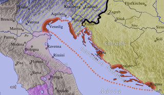
Istria is the largest peninsula to border the Adriatic Sea. Located at the top of the Adriatic between the Gulf of Trieste and the Kvarner Gulf, the peninsula is shared by three countries: Croatia, Slovenia, and Italy, 90% of its area being part of Croatia. Most of Croatian Istria is part of Istria County.
Roč is a village in Istria County, north-west Croatia. Administratively it belongs to the town of Buzet. Roč is considered a historic town rather than a village due to its rich cultural heritage.
Istria County is the westernmost county of Croatia which includes the majority of the Istrian peninsula.
Pula, also known as Pola, is the largest city in Istria County, Croatia, and the seventh-largest city in the country, situated at the southern tip of the Istrian peninsula in northwestern Croatia, with a population of 52,220 in 2021. It is known for its multitude of ancient Roman buildings, the most famous of which is the Pula Arena, one of the best preserved Roman amphitheaters. The city has a long tradition of wine making, fishing, shipbuilding, and tourism. It was the administrative centre of Istria from ancient Roman times until superseded by Pazin in 1991.
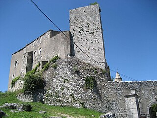
Pazin is a town in western Croatia, the administrative seat of Istria County. It is known for the medieval Pazin Castle, the former residence of the Istrian margraves.
Piran is a town in southwestern Slovenia on the Gulf of Piran on the Adriatic Sea. It is one of the three major towns of Slovenian Istria. The town is known for its medieval architecture, with narrow streets and compact houses. Piran is the administrative seat of the Municipality of Piran and one of Slovenia's major tourist attractions.
The Julian March, also called Julian Venetia, is an area of southern Central Europe which is currently divided among Croatia, Italy, and Slovenia. The term was coined in 1863 by the Italian linguist Graziadio Isaia Ascoli, a native of the area, to demonstrate that the Austrian Littoral, Veneto, Friuli, and Trentino shared a common Italian linguistic identity. Ascoli emphasized the Augustan partition of Roman Italy at the beginning of the Empire, when Venetia et Histria was Regio X.
The Austrian Littoral was a crown land (Kronland) of the Austrian Empire, established in 1849. It consisted of three regions: the Margraviate of Istria in the south, Gorizia and Gradisca in the north, and the Imperial Free City of Trieste in the middle. The region has been contested frequently, with parts of it controlled at various times by the Republic of Venice, Austria-Hungary, Italy, and Yugoslavia among others.
Grožnjan is a settlement and municipality in Croatia. It is part of Croatia's Istria County, which takes up most of the Istrian peninsula. 39% of the municipality's population is Italian.
Kršan is a village and municipality in the eastern part of Istria County, Croatia.
Pićan is a village and municipality in the central part of Istria, Croatia, 12 km southeast of Pazin; elevation 360 m. The chief occupations are agriculture and livestock breeding. It is situated on the D64 state road (Pazin-Kršan-Vozilići). There is a railway station on the former Lupoglav – Raša railway.
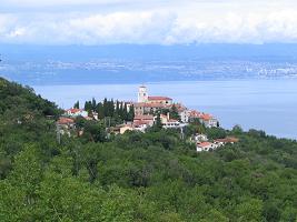
Mošćenice is a village in the municipality of Mošćenička Draga in Primorje-Gorski Kotar County on the Istrian peninsula, close to Opatija, Croatia.
The March of Istria was originally a Carolingian frontier march covering the Istrian peninsula and surrounding territory conquered by Charlemagne's son Pepin of Italy in 789. After 1364, it was the Istrian province of the Habsburg monarchy, the Austrian Empire and Austria-Hungary.
The Raša in Croatian Istria is a major river of Croatia's Istria County. It is 23 kilometres (14 mi) long, and its basin covers an area of 279 km2 (108 sq mi). Its mouth is in the long ria of Raša Bay, which is a drowned river valley scoured out when world sea levels fell, then drowned by the rising waters of the post-glacial era. The Raša rises in springs near Pićan and flows south through a steep-sided valley before opening into the head of the Adriatic Sea. The river, although short in length, has an ancient history as a border.
Istrian Italians are an ethnic group from the Adriatic region of Istria in modern northwestern Croatia and southwestern Slovenia. Istrian Italians descend from the original Latinized population of Roman Histria, from the Venetian-speaking settlers who colonized the region during the time of the Republic of Venice, and from the local Croatian people who culturally assimilated.
Slovene Istria is a region in southwest Slovenia. It comprises the northern part of the Istrian peninsula, and is part of the wider geographical-historical region known as the Slovene Littoral. Its largest urban center is Koper. Other large settlements are Izola, Piran, and Portorož. The entire region has around 120 settlements. In its coastal area, both Slovene and Italian are official languages.
Istria is the largest peninsula in the Adriatic Sea. The peninsula is located at the head of the Adriatic between the Gulf of Trieste and the Bay of Kvarner. It is shared by three countries: Croatia, Slovenia, and Italy.
Labinština is the geographical and historical name of the eastern part of Istria county in Croatia. It covers an area of approximately 220 km2 that is 25 km long and 13 km wide. Geographical borders in the west are the Raša river, and the bay of the same name, in the south and east the sea, and in the north Plomin Bay, the southern part of the Učka massif and Kvarner Bay, and, until the beginning of the 20th century, Lake Čepić. The center is Labin after which it is named. Labin was the head township of the Labinština or Agro Albonese under the Roman Empire, during the Venice Republic between 1365 and 1797, the Austrian rule between 1814-1918 and many other occupations by foreign armies.
Šime Kurelić was a Croatian politician from Pićan and a revivalist of Croatian nationalism among Istrian Croats.
Borut is a village in Istria, Croatia. The name Borut or Borutto is the common name for several small villages and hamlets: Budaki, Buzići, Čuleti, Dausi, Grdinići, Grgurići, Moloni, Orlovići, Poljanice and Sandalji. When Istria was part of the Kingdom of Italy, the village was called Borutto di Bogliuno which was located in the Province of Pola.
![]() | This article includes a list of references, related reading, or external links, but its sources remain unclear because it lacks inline citations .(November 2011) |