
Brewster County is a county located in the U.S. state of Texas. It is in West Texas and its county seat is Alpine. It is one of the nine counties that comprise the Trans-Pecos region, and borders Mexico. Brewster County is the largest county by area in the state - at 6,192 square miles (16,040 km2) it is over three times the size of the state of Delaware, and more than 500 square miles (1,300 km2) bigger than Connecticut.

There are more than 1,500 properties and historic districts in the U.S. State of Colorado listed on the National Register of Historic Places. They are distributed over 63 of Colorado's 64 counties; only the City and County of Broomfield currently has none.

National Park Service rustic – sometimes colloquially called Parkitecture – is a style of architecture that developed in the early and middle 20th century in the United States National Park Service (NPS) through its efforts to create buildings that harmonized with the natural environment. Since its founding in 1916, the NPS sought to design and build visitor facilities without visually interrupting the natural or historic surroundings. The early results were characterized by intensive use of hand labor and a rejection of the regularity and symmetry of the industrial world, reflecting connections with the Arts and Crafts movement and American Picturesque architecture.

Rosemary Inn is a historic resort located at Barnes Point, on south shore of Lake Crescent, about 17.2 miles (27.7 km) southwest of Port Angeles, in Olympic National Park. The Rosemary Inn historic district comprises a 4.5 acres (1.8 ha) area and encompasses several historical structures built between 1914 and the mid-1930s.

The Grand Loop Road is a historic district which encompasses the primary road system in Yellowstone National Park. Much of the 140-mile (230 km) system was originally planned by Captain Hiram M. Chittenden of the US Army Corps of Engineers in the early days of the park, when it was under military administration. The Grand Loop Road provides access to the major features of the park, including the Upper, Midway and Lower geyser basins, Mammoth Hot Springs, Tower Fall, the Grand Canyon of the Yellowstone and Yellowstone Lake.

The Coal Creek Historic Mining District is a gold-mining area in the Yukon-Charley Rivers National Preserve of Alaska dating from the 1930s. It features a gold dredge and a supporting community of several dozen buildings, established by mining entrepreneur Ernest Patty.

This is a list of the National Register of Historic Places listings in Cass County, Minnesota. It is intended to be a complete list of the properties and districts on the National Register of Historic Places in Cass County, Minnesota, United States. The locations of National Register properties and districts for which the latitude and longitude coordinates are included below, may be seen in an online map.

The historical buildings and structures of Zion National Park represent a variety of buildings, interpretive structures, signs and infrastructure associated with the National Park Service's operations in Zion National Park, Utah. Structures vary in size and scale from the Zion Lodge to road culverts and curbs, nearly all of which were designed using native materials and regional construction techniques in an adapted version of the National Park Service Rustic style. A number of the larger structures were designed by Gilbert Stanley Underwood, while many of the smaller structures were designed or coordinated with the National Park Service Branch of Plans and Designs. The bulk of the historic structures date to the 1920s and 1930s. Most of the structures of the 1930s were built using Civilian Conservation Corps labor.
The Elwha Ranger Station is a historic district in Olympic National Park, originally built in the 1930s for the U.S. Forest Service. The complex of fourteen buildings is divided in two by Olympic Hotsprings Road. To the east lie the ranger station and three residences, with nine maintenance buildings on the west side of the road. The complex was turned over to the National Park Service in 1940 when the land was added to Olympic National Park from Olympic National Forest. Construction is typical of USFS practice, and reflects the Forest Service's preference of the time for bungalow and American Craftsman style architecture.

Leavenworth Ranger Station, also known as the Wenatchee River Ranger District, in Leavenworth, Washington was built during 1937-38 by the Civilian Conservation Corps. It was designed by the United States Forest Service's Region 6 USDA Forest Svce. Architecture Group in Rustic architecture. The listing includes nine contributing buildings on a 9.9-acre (4.0 ha) area.
The lookout trees in Kaibab National Forest are the survivors of a system of improvised fire lookout towers that used tall, straight trees as vantage points. The practice of using trees as lookouts was widespread in the western United States during the early 20th century, as there was no need to build a foundation or to pack and assemble a tower structure. Instead, a prominent tree could be selected, and a ladder or a series of spikes could be attached to the tree trunk. For transient use this could be all that was done, but for more permanent use the top 10 feet (3.0 m) of the tree could be lopped, and a platform constructed on the resulting stump. This railed platform was then outfitted with a seat and a platform for an Osborne Fire Finder.
Architects of the National Park Service are the architects and landscape architects who were employed by the National Park Service (NPS) starting in 1918 to design buildings, structures, roads, trails and other features in the United States National Parks. Many of their works are listed on the National Register of Historic Places, and a number have also been designated as National Historic Landmarks.
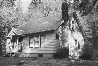
The Peter Roose Homestead is a historic homestead in the U.S. state of Washington that was settled by Peter Roose, an immigrant from Bollnäs, Sweden, in 1907. Located in Olympic National Park, the site was added as a historic district to the National Register of Historic Places in 2007.

The Gakona Historic District encompasses the historic settlement of Gakona, Alaska, which was established as a stagecoach stop on what is now the Glenn Highway in eastern Alaska. The district includes the original Gakona Roadhouse, dating to 1904, and a cluster of buildings around the 1926-28 Gakona Lodge just to its south: two cabins, a horse barn, carriage house, bar, and house. All but two of these are of log construction, and most were built either c. 1904 or 1926–28, when the highway was rebuilt to a higher standard.

The Follett Stone Arch Bridge Historic District encompasses a group of four stone arch bridges in southwestern Townshend, Vermont. All four bridges were built by James Otis Follett, a local self-taught mason, between 1894 and 1910, and represent the single greatest concentration of surviving bridges he built. The district was listed on the National Register of Historic Places in 1976.

The Bluff Historic District, in Bluff, Utah, is a 225 acres (91 ha) historic district which was listed on the National Register of Historic Places in 1995. The district included 11 contributing buildings and six contributing sites.
Slob Historic District, near Christiansted, Virgin Islands, is a historic district which was listed on the National Register of Historic Places in 1987. The listing included nine contributing buildings, three contributing structures, and a contributing site on 9 acres (3.6 ha).
Stewart Ranch, also known as Stewart-Hewlett Ranch, near Woodland, Utah in Wasatch and Summit counties, includes eight buildings which were separately listed on the National Register of Historic Places in 1985. The former ranch is located off Utah State Route 35. Some or all of the ranch is included in what is now the Diamond Bar X Ranch.
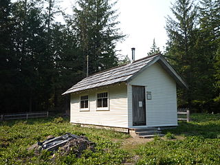
The Seely Creek Guard Station is a forestry guard headquarters, near Ephraim in Utah, United States. It was built in 1907-1908 by the Manti National Forest, with improvements made to the building by the Civilian Conservation Corps during the Great Depression in 1934.

Fountain Green Hydroelectric Plant Historic District, located northwest of Fountain Green, Utah, was listed on the National Register of Historic Places in 1989. The listing included three contributing buildings and a contributing structure.


