The Eli Whitney Museum, in Hamden, Connecticut, is an experimental learning workshop for students, teachers, and families. The museum's main building is located on a portion of the Eli Whitney Gun Factory site, a gun factory erected by Eli Whitney in 1798. The museum focuses on teaching experiments that are the roots of design and invention, featuring hands-on building projects and exhibits on Whitney and A. C. Gilbert.

The Croton Aqueduct or Old Croton Aqueduct was a large and complex water distribution system constructed for New York City between 1837 and 1842. The great aqueducts, which were among the first in the United States, carried water by gravity 41 miles (66 km) from the Croton River in Westchester County to reservoirs in Manhattan. It was built because local water resources had become polluted and inadequate for the growing population of the city. Although the aqueduct was largely superseded by the New Croton Aqueduct, which was built in 1890, the Old Croton Aqueduct remained in service until 1955.
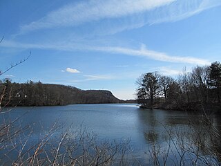
Lake Whitney is a lake in Hamden, Connecticut, that is a part of the Mill River. The lake was a water source for the New Haven, Connecticut, metro area, until it was discontinued in the early 1990s. Now with a new water treatment facility rated for up to 15 million gallons per day, Lake Whitney has been reconnected as a reserve water source for the South Central Connecticut Regional Water Authority. This act has caused a lot of controversy in the area mainly because of residents' concerns about the water flow over the waterfall into the Mill River. Because of this, the regional water authority has agreed to extract only enough water to satisfy the need and change these levels depending upon the season. They also agreed to install a pump to ensure the flow of water over the dam at all times and are currently building a fish ladder to allow fish to swim upriver.

The Elkins Coal and Coke Company Historic District is a historic industrial site near the crossroads village of Bretz in Preston County, West Virginia. It is the site of the last major coke manufacturing facility to use beehive ovens, and was a major industrial site in northern West Virginia in the first half of the 20th century. Surviving elements include a row of 140 beehive ovens. The site was declared a National Historic Landmark in 1983.

Preston City is a village and the original town center of the town of Preston, Connecticut. The core of the village around the junction of Old Northwest Road and Route 164 is designated as the Preston City Historic District, a historic district that is listed on the National Register of Historic Places. The district is located along Old Shetucket and Amos Roads, which, prior to the 1930s, were major thoroughfares.
The Chelsea Parade Historic District encompasses a predominantly residential area north of downtown Norwich. Centered around the Chelsea Parade, a triangular public park, the area has long been a preferred residential area for the city's upper classes, and includes a catalog of architecture from the 18th to 20th centuries. It includes 565 contributing buildings, two other contributing sites, and six contributing objects over an area of 205 acres (83 ha). The district was listed on the National Register of Historic Places in 1989.
The Daniel Pratt Historic District is a historic district that includes 140 acres (57 ha) and 154 buildings in Prattville, Alabama. It is named in honor of Prattville's founder, Daniel Pratt. The district includes the historic downtown and is roughly bounded by 6th Street in the north, Northington Street in the east, 1st Street in the south, and Bridge and Court streets in the west. Architecture in the district includes the Greek Revival, Italianate, and Bungalow styles. It was listed on the National Register of Historic Places on August 30, 1984.

Wheeling Island Historic District is a national historic district located on Wheeling Island in Wheeling, Ohio County, West Virginia. The district includes 1,110 contributing buildings, 5 contributing sites, 2 contributing structures, and 3 contributing objects. It is a largely residential district consisting of two-story, frame detached dwellings built in the mid- to late-19th and early-20th century, including the Irwin-Brues House (1853) and a number of houses on Zane Street. The houses are representative of a number of popular architectural styles including Bungalow, Italianate, Queen Anne, and Colonial Revival. Notable non-residential contributing properties include the Exposition Building (1924), Thompson United Methodist Church (1913-1915), Madison School (1916), firehouse (1930-1931), the Bridgeport Bridge (1893), the Aetnaville Bridge (1891), "The Marina," Wheeling Island Baseball Park, and "Belle Island Park." It includes the separately listed Wheeling Suspension Bridge, Harry C. and Jessie F. Franzheim House, and John McLure House.

Everett Historic District is a national historic district located at Everett, Bedford County, Pennsylvania. The district includes 300 contributing buildings and 1 contributing object in the central business district and surrounding residential area of Everett. The buildings date between about 1830 and 1952, and include notable examples of Gothic Revival and Federal style architecture. Notable non-residential buildings include the U.S. Post Office (1938), Everett Free Library, Zion Lutheran Church, Grace Brethren Church, Barndollar Methodist Church (1860), Everett Hardware Company Building, foundry on North Juniata Street (1874), and Everett Manufacturing Company (1920-1955).

Huntingdon Borough Historic District is a national historic district located at Huntingdon in Huntingdon County, Pennsylvania. The district includes 521 contributing buildings in the central business district and surrounding residential areas of Huntingdon. They date from the late-18th century to the arly-20th century, and are primarily two- and three-story brick or frame structures. The buildings are reflective of popular architectural styles including Federal, Italianate, and Queen Anne. Notable buildings include the county jail (1829), Union Depot (1872), Penn Hunt Hotel (1873-1874), switching tower, Fisher and McMurtie's Store, Reed's Drug Store (1865), Port Building (1875), Iron Front Store (1884), and Blair Building (1889).

Colver Historic District is a national historic district located at Barr Township and Cambria Township in Cambria County, Pennsylvania. The district includes 336 contributing buildings, 5 contributing sites, and 3 contributing structures. The district consists of residential areas, coal mining resources, Cambria and Indiana Railroad shop buildings, and a dairy farm associated with the Ebensburg Coal Company's mine and developed between 1911 and 1943. Notable buildings include a variety of brick and frame workers' housing, the Ebensburg Coal Company office building (1914), stone company store (1912), Colver Amusement Company (1912), Colver Hotel (1912), Colver Presbyterian Church (1915), public school (1927), hospital (1914), Roundhouse No. 1 (1918), Roundhouse No. 2 (1920), and main power building (1911).

Revloc Historic District is a national historic district located at Cambria Township in Cambria County, Pennsylvania. The district includes 203 contributing buildings, one contributing site, and one contributing structure. The district consists of residential areas and utilitarian industrial buildings associated with the Monroe Coal Mining Company and developed between 1917 and 1944. The mine was serviced by the Cambria and Indiana Railroad. Notable buildings include a variety of brick and frame miners' housing, stone company store (1918), payroll office, company boiler house, supply house, machine and blacksmith shop, Revloc Presbyterian Church (1923), Most Holy Redeemer Catholic Church (1924), and Revloc School.

Berwind-White Mine 40 Historic District is a national historic district located at Richland Township and Scalp Level in Cambria County, Pennsylvania. The district includes 121 contributing buildings, 2 contributing sites, and 4 contributing structures. The district consists of a mine site and patch community associated with the Berwind-White Coal Mining Company's Eureka Mine No. 40, and developed between 1905 and the 1941. Notable buildings include over 100 two-story, frame miners' double housing, power house, drift openings, cleaning plant, motor barn, fan house, sand tank, railroad repair car shop, and wash house.
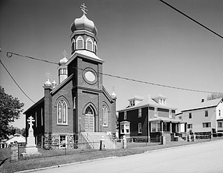
Boswell Historic District is a national historic district located at Boswell in Somerset County, Pennsylvania. The district includes 90 contributing buildings and 1 contributing site. It encompasses an area developed by the Merchant's Mining Company of Baltimore, Maryland starting in 1901. It includes the remaining extant mine resources and the archaeological remains of the mine. They consist of utilitarian industrial buildings, four types of vernacular housing, and a variety of commercial, social, and institutional buildings. Notable buildings include the First National Bank of Boswell (1919), Merchant's Coal Company office (1901), St. Stanislaus Roman Catholic Church (1918), and Sts. Peter and Paul Russian Orthodox Church (1918).

Cairnbrook Historic District is a national historic district located at Shade Township in Somerset County, Pennsylvania. The district includes 132 contributing buildings and 8 contributing structures. It encompasses an area developed by the Loyalhanna Coal and Coke Company of Philadelphia, Pennsylvania between 1912 and 1920. It includes the remaining extant mine resources and the archaeological remains of the mine. They consist of workers' housing, a variety of commercial and social buildings, and a modern draft entry mine with accompanying extractive buildings and structures. Notable buildings include the motor barn, supply house, electric substation, and Loyalhanna Coal and Coke Company Office (1914). The mine operated until 1958.

New Kensington Production Works Historic District, also known as the New Kensington Works and Arnold Works, is a national historic district located at New Kensington, Westmoreland County, Pennsylvania. It encompasses 35 contributing vernacular industrial buildings built between about 1899 and 1947. It was the original manufacturing plant for Alcoa and produced a wide range of aluminum products including kitchen utensils, rods, bars, wire, tubing, sheet foil, automobile parts, bronze powder, industrial chemical utensils, and beer barrels.

Vandergrift Historic District is a national historic district located at Vandergrift, Westmoreland County, Pennsylvania. It encompasses 625 contributing buildings and 2 contributing sites in Vandergrift. They were built between about 1895 and 1925, and includes a mix of residential, commercial, and institutional properties. They are in a variety of popular architectural styles including Romanesque, Queen Anne, and Colonial Revival, and laid out on a plan developed by Frederick Law Olmsted. Notable non-residential buildings include the Casino, train station, company office building, and churches. The two contributing sites are landscaped parks.

Buffalo Mill Historic District is a national historic district located at Buffalo, Union County, South Carolina. The district encompasses 190 contributing buildings and 2 contributing structures associated with the Buffalo Mill textile mill complex and mill village. The mill complex includes the main mill, mill office, power house, ice factory, mill warehouse, company store, and company bank/drug store. The main mill building features applied stylized Romanesque Revival detailing. The mill village housing varies from large, free-classic, Queen Anne style supervisor's houses, to shingle-style bungalows, to simple, one-story, workers residences. The village also includes a school and a baseball field/park.