The Green Line is a light rail system run by the Massachusetts Bay Transportation Authority (MBTA) in the Boston, Massachusetts, metropolitan area. It is the oldest MBTA subway line, and with tunnel sections dating from 1897, the oldest subway in North America. It runs underground through downtown Boston, and on the surface into inner suburbs via six branches on radial boulevards and grade-separated alignments. With an average daily weekday ridership of 137,700 in 2019, it is the third most heavily used light rail system in the country. The line was assigned the green color in 1967 during a systemwide rebranding because several branches pass through sections of the Emerald Necklace of Boston.

The Orange Line is a rapid transit line operated by the Massachusetts Bay Transportation Authority (MBTA) as part of the MBTA subway system. The line runs south on the surface from Oak Grove station in Malden, Massachusetts through Malden and Medford, paralleling the Haverhill Line, then crosses the Mystic River on a bridge into Somerville, then into Charlestown. It passes under the Charles River and runs through Downtown Boston in the Washington Street Tunnel. The line returns to the surface in the South End, then follows the Southwest Corridor southwest in a cut through Roxbury and Jamaica Plain to Forest Hills station.
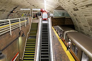
Porter station is a Massachusetts Bay Transportation Authority (MBTA) transit station in Cambridge, Massachusetts. It serves the Red Line rapid transit line, the MBTA Commuter Rail Fitchburg Line, and several MBTA bus lines. Located at Porter Square at the intersection of Massachusetts and Somerville Avenues, the station provides rapid transit access to northern Cambridge and the western portions of Somerville. Porter is 14 minutes from Park Street on the Red Line, and about 10 minutes from North Station on commuter rail trains. Several local MBTA bus routes also stop at the station.

Central station is a Massachusetts Bay Transportation Authority (MBTA) rapid transit station in Cambridge, Massachusetts. It serves the Red Line and has a street-level terminal for the MBTA bus system. It is located at the intersection of Massachusetts Avenue with Western Avenue, Prospect Street, and Magazine Street at Central Square.

Boston College station is a light rail station on the MBTA Green Line B branch. It is located at St. Ignatius Square on the Boston College campus near the intersection of Commonwealth Avenue and Lake Street, on the border between the Brighton neighborhood of Boston and the Chestnut Hill neighborhood of Newton, Massachusetts. Originally opened in 1896, it has been the terminus of the Commonwealth Avenue line since 1900. The current station is planned to be replaced by a new station located in the median of Commonwealth Avenue just east of Lake Street.

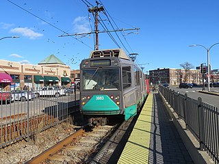
Lechmere station is a Massachusetts Bay Transportation Authority (MBTA) Green Line light rail station in Lechmere Square in East Cambridge, Massachusetts. It is located on the east side of Monsignor O'Brien Highway near First Street, adjacent to the NorthPoint development. The accessible elevated station has a single island platform, with headhouses at both ends. It opened on March 21, 2022, as part of the Green Line Extension (GLX). Lechmere station is served by Green Line D branch and E branch service.

Quincy Center station is an intermodal transit station in Quincy, Massachusetts. It is a transfer station between the MBTA Red Line subway, MBTA Commuter Rail's Old Colony Lines and Greenbush Line, and a number of MBTA bus routes. It is located between Hancock Street and Burgin Parkway in the Quincy Center district. Opened in 1971, the station was covered by a large parking garage which was closed in 2012 due to structural problems and removed several years later. The station is accessible on all modes.
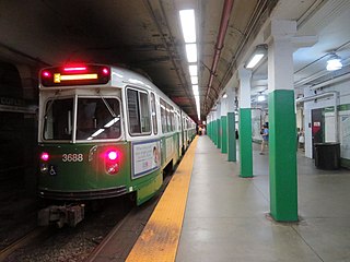
Copley station is an underground light rail station on the MBTA Green Line, located in the Back Bay section of Boston, Massachusetts. Located in and named after Copley Square, the station has entrances and exits along Boylston Street and Dartmouth Street.

Symphony station is an underground light rail station in Boston, Massachusetts on the "E" branch of the MBTA Green Line. It is located at the intersection of Massachusetts Avenue and Huntington Avenue. Symphony is the outermost underground station on the "E" branch; after leaving Symphony, outbound trolleys emerge onto the surface and continue down the median of Huntington Avenue. Symphony station is named after the nearby Symphony Hall.

Broadway station is a subway station in Boston, Massachusetts. It serves the MBTA's Red Line. It is located at the intersection of Dorchester Avenue and Broadway in South Boston. It was opened on December 15, 1917, as part of the Dorchester Extension from Downtown Crossing to Andrew. The station has a single island platform to serve the two tracks.

Shawmut station is a subway station in Boston, Massachusetts. It serves the Ashmont branch of the MBTA's Red Line. It is located on Dayton Street in the Dorchester neighborhood. The station, the only underground station on the Red Line south of Andrew station, sits in a shallow cut-and-cover subway tunnel that runs from Park Street south to Peabody Square where it surfaces at Ashmont station. Shawmut opened along with Ashmont on September 1, 1928, as part of a southward extension of the Cambridge–Dorchester line.

Babcock Street station is a light rail stop on the Massachusetts Bay Transportation Authority (MBTA) Green Line B branch, located in the median of Commonwealth Avenue in the west part of the Boston University campus. The accessible station has two side platforms serving the line's two tracks, with access at Babcock Street and Pleasant Street.
Harvard Avenue station is a light rail station on the MBTA Green Line B branch, located in the Allston neighborhood of Boston, Massachusetts. The station is located on the west side of Commonwealth Avenue at Harvard Avenue, in a residential and commercial district. The station consists of two side platforms, located on opposite sides of Harvard Avenue, which serve the B branch's two tracks. The station is fully accessible. Harvard Avenue is the second-busiest surface stop on the Green Line surface branches, with an average of 4,077 boardings on weekdays.

Allston Street station is a light rail station on the MBTA Green Line B branch, located between the westbound travel lanes and frontage road of Commonwealth Avenue at Allston Street in Allston, Boston, Massachusetts. The station is not accessible. It has two side platforms, located on the near sides of the Allston Street grade crossing, to serve the line's two tracks.

Amory Street station is a light rail stop on the Massachusetts Bay Transportation Authority (MBTA) Green Line B branch, located in the median of Commonwealth Avenue in the west part of the Boston University campus. The accessible station has two side platforms serving the line's two tracks, with access at Amory Street and St. Paul Street.

Boston University Central station is a surface-level light rail station on the MBTA Green Line B branch, located the center median of Commonwealth Avenue west of St. Marys Street in Boston, Massachusetts, surrounded by the Boston University campus. It consists of two side platforms, which serve the B branch's two tracks. The station is accessible, with raised platforms to allow level boarding onto low-floor trams and a high platform on the inbound side to serve high-floor light rail vehicles.

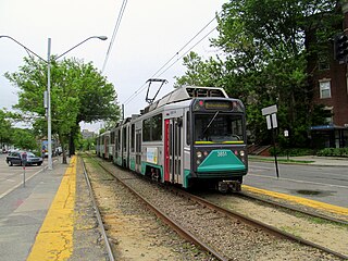
Washington Street station is a surface stop on the Massachusetts Bay Transportation Authority (MBTA)'s Green Line B branch, located in Brighton, Boston. The station is located in the median of Commonwealth Avenue northeast of Washington Street. Washington Street station consists of two side platforms, which serve the B branch's two tracks. The station is fully accessible.

South Station is a transfer station on the MBTA rapid transit Red Line and bus rapid transit Silver Line, located at Summer Street and Atlantic Avenue in downtown Boston, Massachusetts. It is a part of the South Station complex, the second busiest transportation center in New England. Eight MBTA Commuter Rail and three Amtrak intercity rail services terminate at South Station; many of those passengers then transfer to the rapid transit lines to reach other destinations in the city. With 24,639 daily boardings in 2019, South Station is the busiest station on the MBTA rapid transit system.

Medford/Tufts station is a light rail station on the Massachusetts Bay Transportation Authority (MBTA) Green Line located off Boston Avenue near College Avenue in Medford, Massachusetts, adjacent to Tufts University. The accessible station has a single island platform serving the two tracks of the Medford Branch. It opened on December 12, 2022, as part of the Green Line Extension (GLX), which added two northern branches to the Green Line, and is the northern terminus of the E branch.

