History
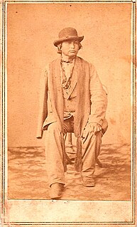
The house was constructed by Moses Grinter where he and his half-Lenape (Delaware) wife lived until he died in 1878 and she in 1905. Grinter's wife's Indian name was “Windagamen,” which meant “Sweetness.” She was one of about 25 Delaware women who became U.S. citizens when the territory became a state. [2] Near this place, the Delaware Crossing (or "Military Crossing"; sometimes "the Secondine'") allowed passage from the old Indian trail where it met the waters of the Kaw River.

The Lenape, also called the Leni Lenape, Lenni Lenape and Delaware people, are an indigenous people of the Northeastern Woodlands, who live in Canada and the United States. Their historical territory included present-day New Jersey and eastern Pennsylvania along the Delaware River watershed, New York City, western Long Island, and the Lower Hudson Valley. Today, Lenape people belong to the Delaware Nation and Delaware Tribe of Indians in Oklahoma; the Stockbridge-Munsee Community in Wisconsin; and the Munsee-Delaware Nation, Moravian of the Thames First Nation, and Delaware of Six Nations in Ontario.

The Great Trail was a network of footpaths created by Algonquian and Iroquoian-speaking indigenous peoples prior to the arrival of European colonists in North America. It connected the areas of New England and eastern Canada, and the mid-Atlantic regions to each other and to the Great Lakes region. Many major highways in the Northeastern United States were later constructed to follow the routes established thousands of years ago by Native Americans moving along these trails.
Around 1831, Grinter, one of the earliest permanent white settlers in the area, set up the Grinter Ferry on the Kansas River here. His house, the Grinter Place, still stands. The ferry was used by individuals such as traders, freighters and soldiers traveling between Fort Leavenworth and Fort Scott on the military road. Others would cross this area on their way to Santa Fe. Grinter operated a trading post at the site and later in the home, the oldest remaining in Wyandotte County, between 1855 and 1860. The area was home to the first non-military post office in Kansas. [3] [4]

Fort Leavenworth is a United States Army installation located in Leavenworth County, Kansas, in the city of Leavenworth since it was annexed on April 12, 1977, in the northeast part of the state. Built in 1827, it is the oldest active United States Army post west of Washington, D.C., and the oldest permanent settlement in Kansas. Fort Leavenworth has been historically known as the "Intellectual Center of the Army."
Fort Scott is a city in and the county seat of Bourbon County, Kansas, United States, 88 miles (142 km) south of Kansas City, on the Marmaton River. As of the 2010 census, the city population was 8,087. It is the home of the Fort Scott National Historic Site and the Fort Scott National Cemetery. Fort Scott is named for Gen. Winfield Scott.
Santa Fe is the capital of the U.S. state of New Mexico. It is the fourth-largest city in the state and the seat of Santa Fe County.
The property remained in the family until 1950, when it was sold and became a chicken dinner restaurant until the mid-1960s. The property was bought by the state of Kansas in 1971. The site is administrated by the Kansas Historical Society as Grinter Place State Historic Site. It was placed on the National Register of Historic Places on January 25, 1971. [1] [4]
The Kansas Historical Society is the official state historical society of Kansas.

Wyandotte County is a county located in the U.S. state of Kansas. As of the 2010 census, the population was 157,505, making it the fourth-most populous county in Kansas. Its county seat and most populous city is Kansas City, with which it shares a unified government. Wyandotte County lies immediately west of Kansas City, Missouri.

Kansas City is the third-largest city in the State of Kansas, the county seat of Wyandotte County, and the third-largest city of the Kansas City metropolitan area. Kansas City, Kansas is abbreviated as "KCK" to differentiate it from Kansas City, Missouri, after which it is named. It is part of a consolidated city-county government known as the "Unified Government". Wyandotte County also includes the independent cities of Bonner Springs and Edwardsville. As of the 2010 census, the city had a population of 145,786 residents. It is situated at Kaw Point, which is the junction of the Missouri and Kansas rivers.

The Kaw Nation are a federally recognized Native American tribe in Oklahoma and parts of Kansas. They come from the central Midwestern United States. The tribe known as Kaw have also been known as the "People of the South wind", "People of water", Kansa, Kaza, Kosa, and Kasa. Their tribal language is Kansa, classified as a Siouan language.

The Republican River is a river in the central Great Plains of North America, rising in the High Plains of eastern Colorado and flowing east 453 miles (729 km) through the U.S. states of Nebraska and Kansas.

Washington Crossing State Park is a 3,575-acre (14 km2) state park in the U.S. state of New Jersey that is part of Washington's Crossing, a U.S. National Historic Landmark area. It is located in the Washington Crossing and Titusville sections of Hopewell Township in Mercer County, north of Trenton along the Delaware River. The park is operated and maintained by the New Jersey Division of Parks and Forestry. It is supported by the Washington Crossing Park Association, a friends group which works to preserve, enhance and advocate for the park.

Turner is a neighborhood within Kansas City, Kansas, United States. It was formerly an unincorporated community of Wyandotte County, similar to Piper, Kansas. Turner has its own school district, Turner USD #202.

The Wyandotte Nation is a federally recognized Native American tribe in Oklahoma. They are descendants of the Wendat Confederacy and Native Americans with territory near Georgian Bay and Lake Huron. Under pressure from Iroquois and other tribes, then from European settlers and the United States government, the tribe gradually moved south and west to Ohio, Michigan, Kansas and finally Oklahoma in the United States.

Titusville is an unincorporated community located within Hopewell Township in Mercer County, New Jersey, United States. The area includes a post office with its own ZIP code (08560), a small village of homes, and a large park dedicated to George Washington's crossing of the Delaware River in 1776. Titusville was added to the National Register of Historic Places in 1983.

Washington Crossing Historic Park is a 500-acre (2 km²) state park operated by the Pennsylvania Department of Conservation and Natural Resources in partnership with the Friends of Washington Crossing Park. The park is divided into two sections. One section of the park, the "lower park," is headquartered in the village of Washington Crossing located in Upper Makefield Township in Bucks County, Pennsylvania. It marks the location of where George Washington crossed the Delaware River during the American Revolutionary War.

The National Register of Historic Places in the United States is a register including buildings, sites, structures, districts, and objects. The Register automatically includes all National Historic Landmarks as well as all historic areas administered by the U.S. National Park Service. Since its introduction in 1966, more than 90,000 separate listings have been added to the register.
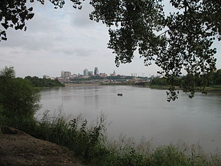
Kaw Point is the name given to the point where the Kansas River terminates at the Missouri River in the West Bottoms area of Kansas City, Kansas. Kaw Point is also where the Missouri ceases its southerly course and turns to flow generally east through the state of Missouri to the Mississippi River at St. Louis.
The timeline of Kansas details past events that happened in what is present day Kansas. Located on the eastern edge of the Great Plains, the U.S. state of Kansas was the home of sedentary agrarian and hunter-gatherer Native American societies, many of whom hunted American bison. The region first appears in western history in the 16th century at the time of the Spanish conquest of Mexico, when Spanish conquistadores explored the unknown land now known as Kansas. It was later explored by French fur trappers who traded with the Native Americans. It became part of the United States in the Louisiana Purchase of 1803. In the 19th century, the first American explorers designated the area as the "Great American Desert."
Delaware Crossing may refer to

The Huron Indian Cemetery in Kansas City, Kansas, also known as Huron Park Cemetery, is now formally known as the Wyandot National Burying Ground. It was established circa 1843, soon after the Wyandot had arrived following removal from Ohio. The tribe settled in the area for years, with many in 1855 accepting allotment of lands in Kansas in severalty. The majority of the Wyandot removed to Oklahoma in 1867, where they maintained tribal institutions and communal property. As a federally recognized tribe, they had legal control over the communal property of Huron Cemetery. For more than 100 years, the property has been a source of controversy between the federally recognized Wyandotte Nation of Oklahoma, which wanted to sell it for redevelopment, and the much smaller present-day Wyandot Nation of Kansas, which wanted to preserve the burying ground.
A Half-Breed Tract was a segment of land designated in the western states by the United States government in the 19th century specifically for Métis of American Indian and European or European-American ancestry, at the time commonly known as half-breeds. The government set aside such tracts in several parts of the Midwestern prairie region, including in Iowa Territory, Nebraska Territory, Kansas Territory, Minnesota Territory, and Wisconsin Territory.

Kaw Mission is a historic church mission at 500 N. Mission Street in Council Grove, Kansas that was home, school and church to 30 Kaw boys from 1851–1854.
Joseph James is the name of two Kansa-Osage-French interpreters on the Kansas and Indian Territory frontier in the 19th century. Both were usually called "Joe Jim" or "Jojim".

Splitlog Church is a historic church building in Grove, Oklahoma.
The Memphis to Little Rock Road-Strong's Ferry Segment is a historic military road in eastern Cross County, Arkansas. This segment of roadway is one of the best-preserved portions of the military road built between Memphis, Tennessee and Little Rock, Arkansas in 1828. This road is notable for the large numbers of westward-traveling pioneers who used it en route to settling the American Plains, and for its use in the forced migration of several Native American tribes in the 1830s. This roadway portion extends from the site of a former ferry crossing on the St. Francis River, westward toward Village Creek State Park, where there is another surviving segment that is hikable.


