Related Research Articles

Kings Canyon National Park is an American national park in the southern Sierra Nevada, in Fresno and Tulare Counties, California. Originally established in 1890 as General Grant National Park, the park was greatly expanded and renamed on March 4, 1940. The park's namesake, Kings Canyon, is a rugged glacier-carved valley more than a mile (1,600 m) deep. Other natural features include multiple 14,000-foot (4,300 m) peaks, high mountain meadows, swift-flowing rivers, and some of the world's largest stands of giant sequoia trees. Kings Canyon is north of and contiguous with Sequoia National Park, and both parks are jointly administered by the National Park Service as the Sequoia and Kings Canyon National Parks.

Sequoia National Park is an American national park in the southern Sierra Nevada east of Visalia, California. The park was established on September 25, 1890, and today protects 404,064 acres of forested mountainous terrain. Encompassing a vertical relief of nearly 13,000 feet (4,000 m), the park contains the highest point in the contiguous United States, Mount Whitney, at 14,505 feet (4,421 m) above sea level. The park is south of, and contiguous with, Kings Canyon National Park; both parks are administered by the National Park Service together as the Sequoia and Kings Canyon National Parks. UNESCO designated the areas as Sequoia-Kings Canyon Biosphere Reserve in 1976.

The Giant Sequoia National Monument is a 328,000-acre (512 sq mi) U.S. National Monument located in the southern Sierra Nevada in eastern central California. It is administered by the U.S. Forest Service as part of the Sequoia National Forest and includes 38 of the 39 Giant Sequoia groves that are located in the Sequoia National Forest, about half of the sequoia groves currently in existence, including one of the ten largest Giant Sequoias, the Boole Tree, which is 269 feet (82 m) high with a base circumference of 112 feet (34 m). The forest covers 824 square miles (2,130 km2).

General Grant Grove, a section of the greater Kings Canyon National Park, was established by the U.S. Congress in 1890 and is located in Fresno County, California. The primary attraction of General Grant Grove is the giant sequoia trees that populate the grove. General Grant Grove's most well-known tree is called General Grant, which is 267 ft (81 m) tall and the third-largest known tree in the world. The General Grant tree is over 1,500 years old and is known as the United States' national Christmas tree. General Grant Grove consists of 154 acres (0.62 km2) and is geographically isolated from the rest of Kings Canyon National Park.
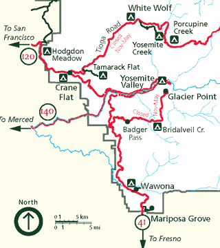
Mariposa Grove is a sequoia grove located near Wawona, California, United States, in the southernmost part of Yosemite National Park. It is the largest grove of giant sequoias in the park, with several hundred mature examples of the tree. Two of its trees are among the 30 largest giant sequoias in the world. The grove closed on July 6, 2015, for a restoration project and reopened on June 15, 2018.

Moro Rock is a granite dome rock formation in Sequoia National Park, California, United States. It is located in the center of the park, at the head of Moro Creek, between Giant Forest and Crescent Meadow. A stairway, designed by the National Park Service and built in 1931, is cut into and poured onto the rock, so that visitors can hike to the top. The view from the rock encompasses much of the Park, including the Great Western Divide. Use of this trail is discouraged during thunderstorms and when it is snowing.
The Generals Highway is a highway that connects State Route 180 and State Route 198 through Sequoia National Park, Sequoia National Forest, Giant Sequoia National Monument, and Kings Canyon National Park in the Sierra Nevada of California. As the road goes through national parks and monuments, the highway is primarily maintained by the federal government instead of a California State Highway controlled by Caltrans.

Mineral King is a subalpine glacial valley located in the southern part of Sequoia National Park, in the U.S. state of California. The valley lies at the headwaters of the East Fork of the Kaweah River, which rises at the eastern part of the valley and flows northwest. Accessed by a long and narrow winding road, the valley is mostly popular with backpackers and hikers.

The Kaweah River is a river draining the southern Sierra Nevada in Tulare County, California in the United States. Fed primarily by high elevation snowmelt along the Great Western Divide, the Kaweah begins as four forks in Sequoia National Park, where the watershed is noted for its alpine scenery and its dense concentrations of giant sequoias, the largest trees on Earth. It then flows in a southwest direction to Lake Kaweah – the only major reservoir on the river – and into the San Joaquin Valley, where it diverges into multiple channels across an alluvial plain around Visalia. With its Middle Fork headwaters starting at almost 13,000 feet (4,000 m) above sea level, the river has a vertical drop of nearly two and a half miles (4.0 km) on its short run to the San Joaquin Valley, making it one of the steepest river drainages in the United States. Although the main stem of the Kaweah is only 33.6 miles (54.1 km) long, its total length including headwaters and lower branches is nearly 100 miles (160 km).

The Brooks River Archaeological District encompasses a large complex of archaeological sites along the banks of the Brooks River in Katmai National Park and Preserve in the U.S. state of Alaska. It includes at least twenty separate settlement sites with documented occupation dates from 2500 BCE to recent (post-contact) history. It was declared a National Historic Landmark in 1993. The site is partly occupied by the Brooks Camp, one of the major visitor areas of the park.
The Fallen Timbers Battlefield was the site of the Battle of Fallen Timbers on 20 August 1794. The battle, a decisive American victory over Native American and British opponents, effectively ended the Northwest Indian War, securing the Old Northwest for settlement. An area believed to be the battle site, located in Maumee, Ohio, was declared a National Historic Landmark in 1960. That site, now the Fallen Timbers State Memorial, is about 0.25 miles (0.40 km) south of the actual battlefield, which was identified in 1995, and much of which is now preserved as part of the Fallen Timbers Battlefield and Fort Miamis National Historic Site along with Fort Miami. The National Historic Site was established in 1999 as a partnership between the National Park Service, Toledo MetroParks, and the Ohio Historical Society.
The Giant Forest Lodge Historic District in Sequoia National Park includes the remnants of what was once an extensive National Park Service Rustic style tourist development for park visitors. Also known as Camp Sierra, the district was listed on the National Register of Historic Places in May 1978. Originally situated in the Giant Forest grove of giant sequoias, the district is notable for its nearly total demolition by the National Park Service to eliminate the impact of development on the Big Trees.

The Giant Forest Village–Camp Kaweah Historic District is located in Sequoia National Park. It is notable as one of two registered historic districts in the park that were largely demolished as part of National Park Service efforts to mitigate the impact of park visitor facilities on the park's giant sequoia groves. They were in a vernacular National Park Service Rustic and American Craftsman Bungalow style.

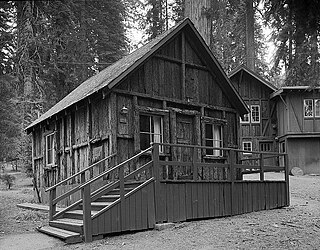
The Cabin Creek Ranger Residence and Dormitory, also known as the Cabin Creek Ranger Station, were built in 1934 and 1935 in Sequoia National Park by the Civilian Conservation Corps. The three-room wood-frame residence and the two-room dormitory are examples of the National Park Service Rustic style.

The Generals' Highway Stone Bridges, built in 1930, are part of the Generals' Highway from the General Grant Grove of giant sequoias in Kings Canyon National Park through Sequoia National Park. One bridge spans the Marble Fork of the Kaweah River in a wooded setting, while the other, similar bridge spans Clover Creek in a bare canyon.

Hospital Rock is a large quartzite rock in Sequoia National Park, located just off of the Generals Highway, on the Middle Fork of the Kaweah River.
Daniel Ray Hull (1890–1964), sometimes stated Daniel P. Hull, was an American landscape architect who was responsible for much of the early planning of the built environment the national parks of the United States during the 1920s. Hull planned town sites, designed landscapes, and designed individual buildings for the Park Service, in private practice, and later for the California State Parks. A number of his works are listed on the U.S. National Register of Historic Places.
Architects of the National Park Service are the architects and landscape architects who were employed by the National Park Service (NPS) starting in 1918 to design buildings, structures, roads, trails and other features in the United States National Parks. Many of their works are listed on the National Register of Historic Places, and a number have also been designated as National Historic Landmarks.

Harold G. Fowler was a National Park Service landscape architect.
The East Walker River Petroglyph Site, near Yerington, Nevada, United States, is a 90-acre (36 ha) archeological site that was listed on the National Register of Historic Places in 1980.
References
- 1 2 "National Register Information System". National Register of Historic Places . National Park Service. July 9, 2010.
- ↑ "Draft General Management Plan and Comprehensive River Management Plan / Environmental Impact Statement: Volume 2" (PDF). National Park Service. Archived from the original (PDF) on August 7, 2004. Retrieved April 19, 2013.