Hales Corners, Wisconsin | |
---|---|
Coordinates: 42°56′29″N88°3′4″W / 42.94139°N 88.05111°W | |
Country | United States |
State | Wisconsin |
County | Milwaukee |
Area | |
• Total | 3.20 sq mi (8.28 km2) |
• Land | 3.19 sq mi (8.27 km2) |
• Water | 0.01 sq mi (0.02 km2) |
Elevation | 781 ft (238 m) |
Population | |
• Total | 7,720 |
• Density | 2,370.61/sq mi (915.37/km2) |
Time zone | UTC-6 (Central (CST)) |
• Summer (DST) | UTC-5 (CDT) |
ZIP Code | 53130, 53131, 53132 |
Area code | 414 |
FIPS code | 55-32075 [3] |
GNIS feature ID | 1565971 [2] |
Website | www |
Hales Corners is a village in Milwaukee County, Wisconsin, United States. The population was 7,720 at the 2020 census. A suburb of Milwaukee, it is part of the Milwaukee metropolitan area.
The land in the area that would eventually encompass the Village was first claimed as French, then British, and eventually as the Northwest Territory of the United States in 1783. It was the land of the Potawatomi Indians until they were forced to move from their land in 1838. They were the dominant tribe in southeast Wisconsin with large villages. Like the Europeans that arrived later, they planted crops, but theirs were beans, squash, and corn. By engaging in the fur trade, the Potawatomi learned to speak French and English, and they eventually intermarried with the Europeans. During the 1830s and 1840s, more settlers arrived, starting with a number of New England families. Among them were three Hale families, whose lineage has been charted to England in the 1200s. Hales Corners traces its history as a Village to 1837, when Seneca Hale laid claim to land here, and its name is credited to his brother William, who became its first Postmaster in 1854. [4] Hales Corners was the site of monthly fairs begun in the mid-1800's, when the plank road between Janesville and Milwaukee passed through the village. First a gathering of horse traders, the fairs became a stock market for farmers trading pigs, cattle, and sheep. [5]
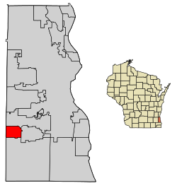
Hales Corners is located in southwestern Milwaukee County. It is bounded by Greenfield on the north, Greendale on the east, Franklin on the south, and New Berlin and Muskego in Waukesha County on the west.
According to the United States Census Bureau, the village has a total area of 3.22 square miles (8.34 km2), of which, 3.21 square miles (8.31 km2) of it is land and 0.01 square miles (0.03 km2) is water. [6] The elevation is 781 feet (238 m).
Census | Pop. | Note | %± |
---|---|---|---|
1960 | 5,549 | — | |
1970 | 7,771 | 40.0% | |
1980 | 7,110 | −8.5% | |
1990 | 7,623 | 7.2% | |
2000 | 7,765 | 1.9% | |
2010 | 7,692 | −0.9% | |
2020 | 7,720 | 0.4% | |
U.S. Decennial Census [7] |
As of the census [3] of 2010, there were 7,692 people, 3,301 households, and 2,066 families living in the village. The population density was 2,396.3 inhabitants per square mile (925.2/km2). There were 3,505 housing units at an average density of 1,091.9 per square mile (421.6/km2). The racial makeup of the village was 94.7% White, 1.0% African American, 0.5% Native American, 1.7% Asian, 0.9% from other races, and 1.2% from two or more races. Hispanic or Latino of any race were 4.3% of the population.
There were 3,301 households, of which 27.3% had children under the age of 18 living with them, 49.1% were married couples living together, 9.8% had a female householder with no husband present, 3.6% had a male householder with no wife present, and 37.4% were non-families. 31.6% of all households were made up of individuals, and 14.6% had someone living alone who was 65 years of age or older. The average household size was 2.31 and the average family size was 2.91.
The median age in the village was 43.9 years. 20.8% of residents were under the age of 18; 8.2% were between the ages of 18 and 24; 22.6% were from 25 to 44; 29.9% were from 45 to 64; and 18.5% were 65 years of age or older. The gender makeup of the village was 47.6% male and 52.4% female.
As of the census [3] of 2000, there were 7,765 people, 3,260 households, and 2,122 families living in the village. The population density was 2,424.7 people per square mile (936.9/km2). There were 3,377 housing units at an average density of 1,054.5 per square mile (407.5/km2). The racial makeup of the village was 97.15% White, 0.22% African American, 0.49% Native American, 0.97% Asian, 0.04% Pacific Islander, 0.57% from other races, and 0.57% from two or more races. Hispanic or Latino of any race were 2.09% of the population.
There were 3,260 households, out of which 27.4% had children under the age of 18 living with them, 53.8% were married couples living together, 8.5% had a female householder with no husband present, and 34.9% were non-families. 29.1% of all households were made up of individuals, and 12.6% had someone living alone who was 65 years of age or older. The average household size was 2.35 and the average family size was 2.93.
In the village, the population was spread out, with 22.1% under the age of 18, 7.2% from 18 to 24, 28.1% from 25 to 44, 24.2% from 45 to 64, and 18.5% who were 65 years of age or older. The median age was 41 years. For every 100 females, there were 91.1 males. For every 100 females age 18 and over, there were 87.9 males.
The median income for a household in the village was $54,536, and the median income for a family was $66,136. Males had a median income of $42,175 versus $33,237 for females. The per capita income for the village was $25,354. About 0.3% of families and 2.0% of the population were below the poverty line, including 0.6% of those under age 18 and 5.0% of those age 65 or over.
The Whitnall School District serves Hales Corners. [8]
Private schools:
Post-secondary:
Milwaukee County is a county located in the U.S. state of Wisconsin. At the 2020 census, the population was 939,489, down from 947,735 in 2010. It is both the most populous and most densely populated county in Wisconsin, and the 45th most populous county nationwide; Milwaukee, its eponymous county seat, is also the most populous city in the state. It was named after the Milwaukee River. The county was created in 1834 as part of Michigan Territory and organized the following year.
West Salem is a village in La Crosse County, Wisconsin, United States, along the La Crosse River. It is part of the La Crosse-Onalaska, WI-MN Metropolitan Statistical Area. The population was 5,277 as of the 2020 census.
Greendale is a village in Milwaukee County, Wisconsin, United States. The population was 14,854 at the 2020 census. Greendale is located southwest of Milwaukee and is a part of the Milwaukee metropolitan area. A planned community, it was established by the US government during the Great Depression.
South Milwaukee is a city in Milwaukee County, Wisconsin, United States. The population was 20,795 at the 2020 census. Situated on the western shore of Lake Michigan, South Milwaukee developed as a streetcar suburb located 5 miles (8.0 km) south of Milwaukee.
West Allis is a city in Milwaukee County, Wisconsin, United States. A suburb of Milwaukee, it is part of the Milwaukee metropolitan area. The population was 60,325 at the 2020 census, making it the eleventh-most populous city in Wisconsin.
Cashton is a village in Monroe County, Wisconsin, United States. The population was 1,158 at the 2020 census.
Sturtevant is a village in Racine County, Wisconsin, United States. The population was 6,919 at the 2020 census.
Union Grove is a village in Racine County, Wisconsin, United States. The population was 4,806 at the 2020 census.
Waldo is a village along the Onion River in Sheboygan County, Wisconsin, United States. The population was 503 at the 2010 census. It has a post office with ZIP code 53093. It is included in the Sheboygan, Wisconsin Metropolitan Statistical Area.
Lyons is a town in Walworth County, Wisconsin, United States. The population was 3,648 at the 2020 census. The unincorporated communities of Lyons and Springfield are located within the town.
Slinger is a village in Washington County, Wisconsin, United States. The population was 5,992 at the 2020 census.
Summit is a village in Waukesha County, Wisconsin, United States. The population was 4,784 at the 2020 census. The former unincorporated communities of Summit Center, Summit Corners, and Waterville are located in the village.
Bayside is a village in Milwaukee and Ozaukee counties in the U.S. state of Wisconsin. The population was 4,482 at the 2020 census. Of this, 4,378 were in Milwaukee County, and only 104 were in Ozaukee County.
Newburg is a village in Ozaukee and Washington counties in the U.S. state of Wisconsin. The population was 1,254 at the 2010 census. Of this, 1,157 were in Washington County, and only 97 were in Ozaukee County.
New Holstein is a city in Calumet County in the U.S. state of Wisconsin. The population was 2,891 as of 2024. The city is located within the Town of New Holstein.
East Troy is a Village in Walworth County, Wisconsin, United States. The population was 5,673 at the 2020 census. The Village is located southwest of the Town of East Troy. A small portion extends into the adjacent Town of Troy. As of 2020, the Village of East Troy has become a rapid growing community in housing and businesses.
Germantown is a village in Washington County, Wisconsin, United States. The population was 20,917 at the 2020 census. The village surrounds the Town of Germantown. In July 2007, Germantown was ranked the 30th most appealing place to live in the United States by Money Magazine.
Eagle is a village in Waukesha County, Wisconsin, United States. At the 2020 census, the population was 2,071. The village is located within the Town of Eagle.
Waukesha is a village in Waukesha County, Wisconsin, United States. The population was 8,457 at the 2020 census. The City of Waukesha is located adjacent to the village.
Franklin is a city in Milwaukee County, Wisconsin, United States. The population was 36,816 at the 2020 census. A suburb of Milwaukee, it is part of the Milwaukee metropolitan area.
{{cite book}}
: |work=
ignored (help){{cite web}}
: CS1 maint: unfit URL (link){{cite web}}
: CS1 maint: unfit URL (link)