
The Lamington National Park is a national park, lying on the Lamington Plateau of the McPherson Range on the Queensland/New South Wales border in Australia. From Southport on the Gold Coast the park is 85 kilometres (53 mi) to the southwest and Brisbane is 110 kilometres (68 mi) north. The 20,600 hectares Lamington National Park is known for its natural environment, rainforests, birdlife, ancient trees, waterfalls, walking tracks and mountain views.
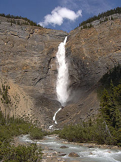
Yoho National Park is a national park of Canada. It is located within the Rocky Mountains along the western slope of the Continental Divide of the Americas in southeastern British Columbia, bordered by Kootenay National Park to the south and Banff National Park to the east in Alberta. The word Yoho is a Cree expression of amazement or awe, and it is an apt description for the park's spectacular landscape of massive ice fields and mountain peaks, which rank among the highest in the Canadian Rockies.
Dakshina Kannada is a district of Karnataka state in India, with its headquarters in the port city of Mangalore. The district covers an area nestled in between the Western Ghats to its east and the Arabian Sea to its west. Dakshina Kannada receives abundant rainfall during the Indian monsoon. It is bordered by Udupi district to the north, Chikmagalur district to the northeast, Hassan district to the east, Kodagu to the southeast and Kasaragod district of Kerala to the south. According to the 2011 census of India, Dakshina Kannada district had a population of 2,083,625. Dakshina Kannada district is the second major district of Karnataka in all aspects after Bangalore Urban. It is the only district in Karnataka state to have all modes of transport like road, rail, water and air due to the presence of a major hub, Mangalore. This financial district is also known as the Cradle of Indian banking.

Chikmagalur, officially known as Chikkamagaluru, is a district in the state of Karnataka. Coffee was first cultivated in India in Chikmagalur. The mountains in Chikmagalur which are a part of the Western Ghats are the source of rivers like Tunga and Bhadra. Mullayanagiri, which is the highest peak in Karnataka is located in the district. It is also a tourist's paradise containing hill stations like Kemmanagundi and Kudremukh and waterfalls like Manikyadhara, Hebbe, Kallathigiri. Chikmagalur district has a rich history as is seen in the Hoysala temple at Amrithapura. Wildlife enthusiasts would be interested in the Kudremukh National Park and Bhadra Wildlife Sanctuary present in this district. Keresanthe Sri Mahalakshmi Temple Keresanthe Kadur (tq) is a religious center for devotees.

Jog Falls, is a waterfall on the Sharavati river located in the Western Ghats Siddapur taluk, Uttara Kannada district, and the view point is located in Sagara Taluk of Shimoga district It is the second highest plunge waterfall in India. It is a segmented waterfall which depends on rain and season becomes a plunge waterfall. The falls are major attractions for tourists and is ranked 36th in the list of free-falling waterfalls, 490th in the world by list of waterfalls by total height, 128th in the list of single-drop waterfalls in the World by the waterfall database.
Kemmannugundi is a hill station in Tarikere taluk of Chikkamagaluru district in the state of Karnataka, India. It is 1434m above sea level. This was the summer retreat of Krishnaraja Wodeyar IV and as a mark of respect to the king, it is also known as Sri Krishnarajendra Hill Station. The station is ringed by the Baba Budan Giri Range, with cascades, mountain streams, and lush vegetation, Kemmangundi’s has ornamental gardens and mountains and valleys views. There is a spectacular sunset view from the Raj Bhavan.
Kudremukha(ಕುದುರೆ ಮುಖ) is a mountain range and name of a peak located in Chikkamagaluru district, in Karnataka, India. It is also the name of a small hill station cum mining town situated near the mountain, about 20 kilometres from Kalasa. The name Kuduremukha literally means 'horse-faced (Kannada) and refers to a particular picturesque view of a side of the mountain that resembles a horse's face. It was also referred to as 'Samseparvata', historically since it was approached from Samse village. Kuduremukha is Karnataka's 2nd highest peak after Mullayanagiri. The nearest International Airport is at Mangalore which is at a distance of 99 kilometres.

Baba Budan Giri also known as Dattatray Peeta is a mountain in range of the Western Ghats of India. Located in the Chikmagaluru taluk, Chikmagaluru District of Karnataka, Dattatreya peeta is known for its shrine to a pilgrimage site for Hindus .Sangh parivar organizations started "Datta Jayanti" celebrations in the late 2000s as part of their fight to claim "Sri Guru Dattatreya Swami Dattapit". People go to have a darshan of the Samadhi. The main peaks in this range are the Mullayanagiri and Baba Budangiri. Collectively, these peaks are known as Chandradrona Parvatha Shreni as they naturally form the shape of a crescent moon.

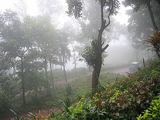
Agumbe is a settlement situated in the Thirthahalli taluka of Shimoga district, Karnataka, India. It is nestled in the thickly forested Malenadu region of the Western Ghats mountain range. Owing to its high rainfall, it has received the epithet of "The Cherrapunji of South India", after Cherrapunji, one of the rainiest places in India.

Mudigere is a Town Panchayath and Taluk in Chikkamagaluru district in the Indian state of Karnataka. It is 30 km from the district headquarters.

Sakleshpur, Sakleshpura or Sakleshapura(ಸಕಲೇಶಪುರ) is a hill station town and headquarters of Sakleshpur taluk in Hassan district in the Indian state of Karnataka.

Moodabidri, is a town and taluk in Dakshina Kannada district. It lies 34 km northeast of the district headquarters, Mangalore, in Karnataka, India.

Pushpagiri, at 1,712 metres (5,617 ft), is the highest peak in Pushpagiri Wildlife Sanctuary in the Western Ghats of Karnataka. It is located in the Somwarpet Taluk, 20 kilometres (12 mi) from Somwarpet in the northern part of Kodagu district on the border between Dakshina Kannada and Kodagu district and hassan districts. It is 4th highest peak of Karnataka. The Sanskrit name of the mountain is Puṣpagiri while its Prakrit form is Puphagiri, which is mentioned in the Nagarjunakond Second Apsidal Temple inscription, although this may refer to a different mountain to the north of Cuddapah, in Andhra Pradesh.

Buntzen Lake is a 4.8 kilometres (3 mi) long lake in Anmore, British Columbia, Canada, in the Greater Vancouver area. It is named after the first general manager of the B.C. Electric Co., Johannes Buntzen. There is a smaller lake just to the north named McCombe Lake.

Bhagamandala is a pilgrimage place in Kodagu district of the Indian state of Karnataka.

Charmadi Ghat (Charmady) is a Ghat in Belthangady taluk of Dakshina Kannada and Mudigere taluk of Chikkamagaluru. It is one of the points in Western ghats through which motorable road passes connecting Dakshina Kannada with Chikkamagaluru district. The section of ghat is known by the name of Charmadi Ghat. It lies on National Highway 73 which connects Mangaluru to Tumkuru. The nearest places are Charmadi village, Ujire, Belthangady, Puttur, Kottigehara, Balur and Kalasa Estate and Banakal.
Gangamoola is a hill in the Chikkamagaluru district of the state of Karnataka, India. Also known as Varaha Parvata, it is one of the hills in the Western Ghats range and is known for being the source of three rivers, Tunga, Bhadra and Netravathi.

KIOCL Limited, formerly Kudremukh Iron Ore Company Limited is a government owned enterprise with its head office and administrative activities in Bangalore. It has a pelletisation plant in Mangalore and had an iron ore mine in Kudremukh. It is under the ownership of Ministry of Steel, Government of India. The Kudremukh mine, one of the largest iron ore mines in the world, was closed in 2006.
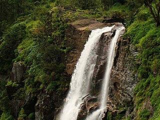
Bandaje falls, also known as Bandaje Arbi falls is a waterfall located in the Charmadi ghat section of the Western Ghats in the Belthangady taluk of Dakshina Kannada district, Karnataka. The waterfalls can be reached only by undertaking trekking in thick forests and grass lands with the help of local guides and in summer the waterfalls goes dry. The height of waterfalls is about 200 feet.

The city of Mangalore is proclaimed as the gateway to Karnataka and lies nestled between the blue waters of the Arabian Sea and the green, towering hills of the Western Ghats. The 184 square km city is spread out over the backwaters of the two rivers, Netravati and Gurpura.


