Gopalganj is a district in the Dhaka Division of Bangladesh. The district has about 1,172,415 civilians and its surface area is 1,490 km2. The main city of the district is also called Gopalganj. It stands on the bank of the Madhumati river and located at 23°00’47.67" N 89°49’21.41". It is bounded by Faridpur district on the North, Pirojpur and Bagerhat district on the South, Madaripur & Barisal district on the East and Narail district on the West.

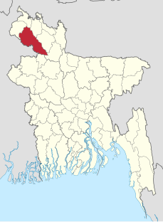
Kurigram District is located in the Rangpur Division, in northern Bangladesh along the border with India. At first it was a mahakuma and then established as a district in 1984.

Mymensingh is a district in Mymensingh division, Bangladesh, and is bordered on the north by the Meghalaya state of India and the Garo Hills, on the south by Gazipur District, on the east by the districts of Netrokona and Kishoreganj, and on the west by the districts of Sherpur, Jamalpur and Tangail. Mymensingh town is the district headquarters.
Dinajpur district is a district in the Rangpur Division of northern Bangladesh. Dinajpur is the largest district among all sixteen northern districts of Bangladesh.

Patuakhali is a district in South-central Bangladesh in the Barisal Division. This district is the main entrance for the beach of Kuakata.

Gaibandha is a district in Northern Bangladesh. It is a part of the Rangpur Division. Gaibandha subdivision was established in 1875. Gaibandha was previously known as Bhabanigonj. The name was changed from Bhabanigonj to Gaibandha in 1875. Gaibandha was established as a district on 15 February 1984. Gaibandha is the administrative headquarter and largest urban centre of this district.

Nilphamari is a district in Northern Bangladesh. It is a part of the Rangpur Division. It is about 400 kilometres to the northwest of the capital Dhaka. It has an area of 1,547 square kilometres (597 sq mi). Nilphamari is bounded by Rangpur and Lalmonirhat in east, Rangpur and Dinajpur in south, Dinajpur and Panchagarh in west, Cooch Behar of India in north. There are many rivers in Nilphamari such as the Tista, Buritista, Isamoti, Jamuneshwari, Dhum, Kumlai, Charalkata, Sorbomongola, Salki, Chikli, Deonai and many more.

Rangpur is a district in Northern Bangladesh. It is a part of the Rangpur Division.

Bangladesh is divided into 8 Divisions (Bibhag) and 64 Districts, although these have only a limited role in public policy. For the purposes of local government, the country is divided into Upazila (sub-districts), Municipalities (Pourashova), City Corporations and Union Councils . The diagram below outlines the five tiers of government in Bangladesh.

Birampur is an upazila of Dinajpur District in the Division of Rangpur, Bangladesh. Birampur is an important city near India Border. This upazila is 300 km away from Capital Dhaka and nearly 56 km away from Dinajpur City. Inspite of being far from Capital this north Bengal city is flourishing economically and Culturally. A brach of Jamuna River is being flowing through Birampur Upazila.

Badarganj is an upazila of Rangpur District in the Division of Rangpur, Bangladesh.
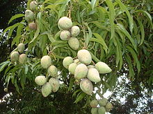
Mithapukur is an upazila of Rangpur District in the division of Rangpur, Bangladesh. The upazila is situated in the middle of Rangpur, surrounded by Rangpur Sadar to the north, Pirganj to the south, Badarganj and Phulbari to the west and Pirgachha and Sundarganj to the east. Mithapukur is famous for being the birthplace of Begum Rokeya Sakhawat Hossain and its sweet mango Harivanga.
Pirganj is an upazila of Rangpur District in the division of Rangpur, Bangladesh. Pirganj Upazila area 409.37 km2, located in between 25°18' and 25°31' north latitudes and in between 89°08' and 89°25' east longitudes. It is bounded by mithapukur upazila on the north, Palashbari, Ghoraghat and Nawabganj Sadar (Dinajpur) upazilas on the south, Sadullapur upazila on the east, Mithapukur, Nawabganj Sadar (Dinajpur) and Ghoraghat upazilas on the west.
Ullapara is an upazila in Sirajganj District, Rajshahi Division, Bangladesh. It is known as the gateway to North Bengal, since the Dhaka-Rangpur and Dhaka-Rajshahi highways intersect at Hatikumrul in Ullapara.
Ranisankail is an Upazila of Thakurgaon District in the Division of Rangpur, Bangladesh.

Rangpur-3 is a constituency represented in the Jatiya Sangsad of Bangladesh. Saad Ershad is the current MP of this constituency.
Kurigram-3 is a constituency represented in the Jatiya Sangsad of Bangladesh since 2019 by MA Matin of the Awami League.

Kurigram-2 is a constituency represented in the Jatiya Sangsad of Bangladesh since 2019 by Ponir Uddin Ahmed of the Jatiya Party (Ershad)