The Saco River is a river in northeastern New Hampshire and southwestern Maine in the United States. It drains a rural area of 1,703 square miles (4,410 km2) of forests and farmlands west and southwest of Portland, emptying into the Atlantic Ocean at Saco Bay, 136 miles (219 km) from its source. It supplies drinking water to roughly 250,000 people in thirty-five towns; and historically provided transportation and water power encouraging development of the cities of Biddeford and Saco and the towns of Fryeburg and Hiram.

The Androscoggin Swinging Bridge is a pedestrian suspension bridge spanning the Androscoggin River in Maine between the towns of Topsham in Sagadahoc County and Brunswick in Cumberland County. The bridge was built in 1892 as a timesaving approach for employees of the Cabot Manufacturing Company of Brunswick, could have safer and easier passage across the river.
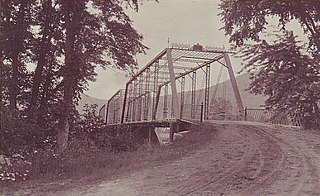
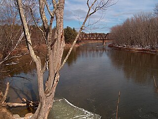
The Meadow Bridge was a historic bridge across the Androscoggin River located on a spur of North Road in Shelburne, New Hampshire. It was a multi-span pin-connected truss bridge that was the first on its site when it was built in 1897 by the Groton Bridge and Manufacturing Co. The bridge consisted of three central through Pratt trusses, one pony Pratt truss, and one steel girder section. The ends of the bridge rested on stone abutments, while the interior spans were supported by circular steel piers filled with concrete and anchored in place by timber piles. The bridge was bypassed in 1984 by a modern bridge. In 2004 it was dismantled and stored on the banks of the river for future rehabilitation.

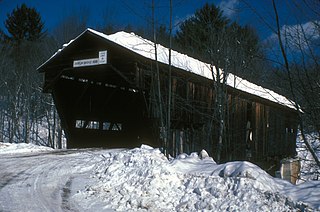
The Whittier Bridge is a historic wooden covered bridge in Ossipee, New Hampshire. The bridge carried an old alignment of New Hampshire Route 25 over the Bearcamp River. Built in 1870, it is one of New Hampshire's few surviving 19th-century covered bridges, and a rare example of a Paddleford truss. The bridge was listed on the National Register of Historic Places in 1984. It was closed to vehicular traffic in 1989, and was removed from its footings for restoration in 2008. As of September 2019, the bridge is resting on Nudd Road adjacent to the crossing point. It was placed back on its abutments in the late fall of 2022.

Watson Settlement Bridge was a historic covered bridge in eastern Littleton, Maine, United States. Built in 1911, it was one of the youngest of Maine's few surviving covered bridges. It formerly carried Framingham Road over the Meduxnekeag River, but was closed to traffic, the road passing over a modern bridge to its south. It was listed on the National Register of Historic Places in 1970. It was destroyed by fire on July 19, 2021, and subsequently delisted from the National Register in 2023.

Lee's Creek Covered Bridge is a historic wooden bridge on Lee's Creek Road 0.1 miles (0.16 km) south of Kentucky Route 8 near Dover, Kentucky. It is 61 feet (19 m) long with a double set of Queen post trusses on each side.

The East Putney Brook Stone Arch Bridge is a historic stone arch bridge in eastern Putney, Vermont. Built in 1902, it is a rare statewide example of a 20th-century stone bridge, and one of a number of such area bridges built by Townshend farmer and mason James Otis Follett. It was listed on the U.S. National Register of Historic Places in 1976. The bridge is located just west (upstream) of the present alignment of River Road, which it formerly carried.

Officially known as the Cilleyville-Bog Bridge, this structure began its tenure named simply Bog Bridge. There was already a Cilleyville Bridge just eight hundred feet away on the Blackwater River, located in an area of Andover named after the Cilley family. When that bridge burned down in 1908, the Bog Bridge became known as the Cilleyville Bridge since it was the only one left in Cilleyville.
The Durgin Bridge is a covered bridge carrying Durgin Bridge Road over the Cold River in eastern Sandwich, New Hampshire. Built in 1869, it is a rare surviving example of a Paddleford truss bridge, and one of the few surviving 19th-century covered bridges in New Hampshire. It was listed on the National Register of Historic Places in 1983.

The Prentiss Bridge is a historic covered bridge in Langdon, New Hampshire. Built about 1874, it spans Great Brook just east of the modern alignment of Chester Turnpike, which it carried until it was bypassed by a modern bridge in 1955. At 36 feet (11 m) in length, it is the shortest 19th-century covered bridge built for use on a public roadway in New Hampshire that is still standing. The bridge was listed on the National Register of Historic Places in 1973.

Babb's Bridge is a covered bridge spanning the Presumpscot River on Hurricane Road, between the towns of Gorham and Windham in Cumberland County, Maine. Built in 1976, it is a replica of a 19th-century bridge that stood on the site until destroyed by arson in 1973. The bridge was listed on the National Register of Historic Places in 1972, and was delisted in 2023.

The Lovejoy Bridge is a historic covered bridge in South Andover, Maine. It is a Paddleford truss bridge, which carries Covered Bridge Road over the Ellis River, about 9 miles (14 km) north of US Route 2. Built in 1868, it is one of a small number of 19th-century covered bridges remaining in the state, and it is the state's shortest covered bridge. It was listed on the National Register of Historic Places in 1970.

The Porter-Parsonsfield Bridge is a covered bridge in western Maine, and one of the few 19th-century covered bridges left in the state. The bridge spans the Ossipee River just east of the modern alignment of North Road, which it formerly carried, between the towns of Porter and Parsonsfield. Built in 1876 by the towns, it is a Paddleford truss bridge which has been strengthened with laminated arches. The bridge was closed to traffic in 1960, and is now maintained by the state. It was listed on the National Register of Historic Places in 1970.

The Sunday River Bridge, also known locally as the Artists Bridge, is a historic covered bridge in Newry, Maine. It is located northeast of the Sunday River Ski Resort, adjacent to the crossing of the Sunday River by Sunday River Road, which the bridge formerly carried. Built in 1872, it is one of Maine's few surviving 19th-century covered bridges. The bridge was listed on the National Register of Historic Places in 1970.

The Robyville Bridge is a historic covered bridge in Corinth, Maine. Built in 1876, this Howe truss bridge is one of the state's few surviving 19th-century covered bridges. It carries Covered Bridge Road across Kenduskeag Stream in the southern part of the rural community. It was listed on the National Register of Historic Places in 1970 and designated as a Maine Historic Civil Engineering Landmark by the American Society of Civil Engineers in 2002.

The Iron Bridge at Howard Hill Road is a modern pony truss bridge, carrying Howard Hill Road across the Black River in southeastern Cavendish, Vermont. It is the replacement for a historic 1890 Pratt through truss bridge, which is now in storage. The historic bridge was listed on the National Register of Historic Places in 1982.
The Coburn Covered Bridge is a historic covered bridge, carrying Coburn Road over the Winooski River in eastern East Montpelier, Vermont. Built in 1851, it is the town's only surviving 19th-century covered bridge. It was listed on the National Register of Historic Places in 1974.

The Martin Covered Bridge is a wooden covered bridge spanning the Winooski River off United States Route 2 in southern Marshfield, Vermont. Built about 1890, it is the only surviving historic covered bridge in the town. It was listed on the National Register of Historic Places in 1974.

The Burrington Covered Bridge is a historic queenpost truss covered bridge in Lyndon, Vermont. Built in the 19th century, it is one of five covered bridges in Lyndon. It formerly carried Burrington Bridge Road across the Passumpsic River; it has been bypassed by a modern bridge. It was listed on the National Register of Historic Places in 1974.

The Greenbanks Hollow Covered Bridge is a historic covered bridge built in 1886, carrying Greenbanks Hollow Road across Joes Brook in southern Danville, Vermont. It is the only surviving 19th-century covered bridge in the town. It was listed on the National Register of Historic Places in 1974.


