Hickory Grove, South Carolina

Last updated

Hickory Grove, South Carolina
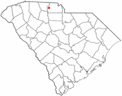
SCMap-doton-HickoryGrove.PNG
Location of Hickory Grove, South Carolina
Coordinates: 34°59′2″N81°24′57″W / 34.98389°N 81.41583°W / 34.98389; -81.41583
Country United States
State South Carolina
County York
Area
[1]
  Total
1.67 sq mi (4.33 km2)
  Land1.67 sq mi (4.33 km2)
  Water0.00 sq mi (0.00 km2)
Elevation
[2]
682 ft (208 m)
Population
 (2020) [3]
  Total
449
  Density268.86/sq mi (103.80/km2)
Time zone UTC-5 (Eastern (EST))
  Summer (DST) UTC-4 (EDT)
ZIP code
29717
Area code(s) 803, 839
FIPS code 45-33640 [4]
GNIS feature ID1249501 [2]
Website townofhickorygrove.com

Hickory Grove is a town in York County, South Carolina, United States. The population was 449 at the 2020 census..

Contents

Geography

Hickory Grove is located at 34°59′2″N81°24′57″W / 34.98389°N 81.41583°W / 34.98389; -81.41583 (34.983982, -81.415899). [5]

According to the United States Census Bureau, the town has a total area of 1.3 square miles (3.4 km2), all land.

Demographics

Historical population
CensusPop.Note
1890 134
1900 289115.7%
1910 285−1.4%
1920 3015.6%
1930 3185.6%
1940 272−14.5%
1950 2751.1%
1960 2874.4%
1970 37731.4%
1980 344−8.8%
1990 287−16.6%
2000 33717.4%
2010 44030.6%
2020 4492.0%
U.S. Decennial Census [6] [3]

As of the census [4] of 2000, there were 337 people, 115 households, and 93 families residing in the town. The population density was 261.0 inhabitants per square mile (100.8/km2). There were 129 housing units at an average density of 99.9 per square mile (38.6/km2). The racial makeup of the town was 69.44% White, 28.78% African American, 0.30% Asian, 0.59% from other races, and 0.89% from two or more races. Hispanic or Latino of any race were 2.37% of the population.

There were 115 households, out of which 40.0% had children under the age of 18 living with them, 62.6% were married couples living together, 13.9% had a female householder with no husband present, and 18.3% were non-families. 13.9% of all households were made up of individuals, and 8.7% had someone living alone who was 65 years of age or older. The average household size was 2.93 and the average family size was 3.28.

In the town, the population was spread out, with 27.3% under the age of 18, 11.0% from 18 to 24, 27.3% from 25 to 44, 23.1% from 45 to 64, and 11.3% who were 65 years of age or older. The median age was 36 years. For every 100 females, there were 104.2 males. For every 100 females age 18 and over, there were 100.8 males.

The median income for a household in the town was $44,000, and the median income for a family was $46,563. Males had a median income of $28,229 versus $20,500 for females. The per capita income for the town was $17,014. 11.6% of the population and 7.2% of families fall below the poverty line. Out of the total population, 16.7% of those under the age of 18 and 12.5% of those 65 and older were living below the poverty line.

Media

Hickory Grove is home to a free daily online and monthly print newspaper, the YoCoNews that covers all of York and Lancaster counties. [7]

Notable people

Related Research Articles

<span class="mw-page-title-main">Center Point, Indiana</span> Town in Indiana, United States

Center Point is a town in Sugar Ridge Township, Clay County, Indiana, United States. The population was 242 at the 2010 census. It is part of the Terre Haute Metropolitan Statistical Area.

<span class="mw-page-title-main">Pilot Grove, Missouri</span> City in Missouri, United States

Pilot Grove is a city in the Pilot Grove Township in northern Cooper County, Missouri, United States. The population was 768 at the 2010 census.

Burdett is a village in Schuyler County, New York, United States. The population was 357 at the 2000 census.

<span class="mw-page-title-main">Drexel, North Carolina</span> Town in North Carolina, United States

Drexel is a town in Burke County, North Carolina, United States. The population was 1,858 at the 2010 census. It is part of the Hickory–Lenoir–Morganton Metropolitan Statistical Area.

<span class="mw-page-title-main">Brookford, North Carolina</span> Town in North Carolina, United States

Brookford is a town in Catawba County, North Carolina, United States. The population was 442 at the 2020 census. It is part of the Hickory–Lenoir–Morganton Metropolitan Statistical Area. The Town of Brookford was incorporated March 1, 1907. Brookford began as a mill village, deriving its name from the combination of the two owner's names Holbrook and Shuford. The town has 4.56 miles of roadage.

<span class="mw-page-title-main">St. Stephens, North Carolina</span> Census-designated place in North Carolina, United States

St. Stephens is a census-designated place (CDP) in Catawba County, North Carolina, United States. The population was 8,759 at the 2010 census, down from 9,439 in 2000. It is part of the Hickory–Lenoir–Morganton Metropolitan Statistical Area.

<span class="mw-page-title-main">Hickory, Oklahoma</span> Town in Oklahoma, United States

Hickory is a town in Murray County, Oklahoma, United States. The population was 86 as of the 2020 Census.

<span class="mw-page-title-main">Elko, South Carolina</span> Town in South Carolina, United States

Elko is a town in Barnwell County, South Carolina, United States. According to the 2010 census the population was 193.

<span class="mw-page-title-main">Kline, South Carolina</span> Town in South Carolina, United States

Kline is a town in Barnwell County, South Carolina, United States. The population was 197 at the 2010 census.

<span class="mw-page-title-main">Snelling, South Carolina</span> Town in South Carolina, United States

Snelling is a town in Barnwell County, South Carolina, United States. The population was 274 at the 2010 census.

<span class="mw-page-title-main">Oak Grove, South Carolina</span> Census-designated place in South Carolina, United States

Oak Grove is a census-designated place (CDP) in Lexington County, South Carolina, United States. The population was 10,291 at the 2010 census. It is part of the Columbia Metropolitan Statistical Area.

Seven Oaks is a census-designated place (CDP) in Lexington County, South Carolina, United States, 8 miles (13 km) northwest of downtown Columbia, the state capital. The population of the CDP was 15,144 at the 2010 census. It is part of the Columbia Metropolitan Statistical Area.

<span class="mw-page-title-main">Peak, South Carolina</span> Town in South Carolina, United States

Peak is a town in Newberry County, South Carolina, United States. The population was 64 at the 2010 census.

<span class="mw-page-title-main">St. Andrews, South Carolina</span> Census-designated place in South Carolina, United States

St. Andrews is a census-designated place (CDP) in Richland County, South Carolina, United States. The population was 20,493 at the 2010 census. It is part of the Columbia, South Carolina Metropolitan Statistical Area.

<span class="mw-page-title-main">Central Pacolet, South Carolina</span> Town in South Carolina, United States

Central Pacolet is a town in Spartanburg County, South Carolina, United States, along the Pacolet River. The population was 216 at the 2010 census.

<span class="mw-page-title-main">Roebuck, South Carolina</span> CDP in South Carolina, United States

Roebuck is a census-designated place (CDP) in Spartanburg County, South Carolina, United States. The population was 2,200 at the 2010 census.

<span class="mw-page-title-main">Jonesville, South Carolina</span> City in South Carolina, United States

Jonesville is a town in Union County, South Carolina, United States. The population was 911 at the 2010 United States Census.

<span class="mw-page-title-main">Cedar Grove, West Virginia</span> Town in West Virginia, United States

Cedar Grove is a town in Kanawha County, West Virginia, United States. The population was 714 at the 2020 census. Cedar Grove was incorporated in 1902. Its name is derived from the time the town was established, when a large juniper forest, misidentified as cedars by early settlers, was growing at that location. Cedar Grove is the site of Fort Kelley and the oldest settlement in the Kanawha Valley, dating from 1773. Landmarks located here include the Tompkins Home (1844) and the Old Brick Church (1853). The current mayor is as of July 1, 2023, is Melissa (Missy) Young.

<span class="mw-page-title-main">Hickory Grove, Wisconsin</span> Town in Wisconsin, United States

The Town of Hickory Grove is located in Grant County, Wisconsin, United States. The population was 568 at the 2020 census. The unincorporated communities of Hickory Grove and Homer are located in the town.

<span class="mw-page-title-main">Cooperstown, Wisconsin</span> Town in Wisconsin, United States

Cooperstown is a town in Manitowoc County, Wisconsin, in the United States. As of the 2000 census, the town population was 1,403.

References

  1. "ArcGIS REST Services Directory". United States Census Bureau. Retrieved October 15, 2022.
  2. 1 2 U.S. Geological Survey Geographic Names Information System: Hickory Grove, South Carolina
  3. 1 2 "Census Population API". United States Census Bureau. Retrieved October 15, 2022.
  4. 1 2 "U.S. Census website". United States Census Bureau . Retrieved January 31, 2008.
  5. "US Gazetteer files: 2010, 2000, and 1990". United States Census Bureau. February 12, 2011. Retrieved April 23, 2011.
  6. "Census of Population and Housing". Census.gov. Retrieved June 4, 2015.
  7. YoCoNews.com