Hidden Valley, Queensland

Last updated

Hidden Valley
Queensland
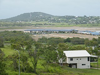
Capricorn Coast Hospital.jpg
Capricorn Coast Hospital, 2012
Australia Queensland location map.svg
Red pog.svg
Hidden Valley
Coordinates 23°10′05″S150°43′08″E / 23.1680°S 150.7188°E / -23.1680; 150.7188 (Hidden Valley (centre of locality))
Population879 (2021 census) [1]
 • Density66.59/km2 (172.5/sq mi)
Postcode(s) 4703
Elevation10–160 m (33–525 ft) [2]
Area13.2 km2 (5.1 sq mi)
Time zone AEST (UTC+10:00)
Location
LGA(s) Livingstone Shire
State electorate(s) Keppel
Federal division(s) Capricornia
Suburbs around Hidden Valley:
Barmaryee Yeppoon Yeppoon
Bondoola Hidden Valley Taroomball
Bondoola Tanby Tanby

Hidden Valley is a mixed-use locality in the Livingstone Shire, Queensland, Australia. [3] In the 2021 census, Hidden Valley had a population of 879 people. [1]

Contents

Geography

The Rockhampton-Yeppoon Road (as Yeppoon Road) runs along the northern boundary. [4]

The land use is a mixture of grazing on native vegetation, horticulture, housing and undeveloped land. Historical, the housing was rural residential in the north-east of the locality, but the increasing population reflects the recent development of suburban land parcels in the west of the locality. [2]

History

Jangga, also known as Yangga, is an Indigenous language of Central Queensland. [5]

Demographics

In the 2016 census, Hidden Valley had a population of 421 people. [6]

In the 2021 census, Hidden Valley had a population of 879 people. [1]

Education

There are no schools in Hidden Valley. The nearest government primary schools are Yeppoon State School in neighbouring Yeppoon to the north and Taranganba State School in Taranganba to the east. The nearest government secondary school is Yeppoon State High School in Yeppoon. [7]

Facilities

Capricorn Coast Hospital & Health Service is a public hospital at 8 Hoskyn Drive ( 23°08′37″S150°44′01″E / 23.1437°S 150.7337°E / -23.1437; 150.7337 (public hospital) ). It includes dental services, an 24-hour emergency department, and an ambulance station. [8] [9]

Amenities

There is a park on Naomi Drive Park ( 23°08′46″S150°44′25″E / 23.1460°S 150.7402°E / -23.1460; 150.7402 (Naomi Drive Park) ). [10]

Related Research Articles

<span class="mw-page-title-main">Yeppoon</span> Town in Queensland, Australia

Yeppoon is a coastal town and locality in the Shire of Livingstone, Queensland, Australia. Yeppoon is renowned for its beaches, tropical climate, and the islands out on the bay. Located 41 kilometres (25 mi) from the city of Rockhampton, Yeppoon is the seat of the Shire of Livingstone and the principal town on the Capricorn Coast, a string of seaside communities stretching more than 150 kilometres (93 mi) from north to south. The beaches and shallow coves provide a destination both for tourists and retirees settling down in Central Queensland. Offshore, there are 27 islands including Great Keppel Island which is 20 kilometres (12 mi) from Yeppoon. In the 2021 census, the locality of Yeppoon had a population of 7,037 people; this does not include any neighbouring suburbs.

<span class="mw-page-title-main">Capricorn Coast</span> Region in Queensland, Australia

The Capricorn Coast is a stretch of coastline in Central Queensland, Australia and is part of the Shire of Livingstone.

<span class="mw-page-title-main">Kinka Beach, Queensland</span> Suburb of Shire of Livingstone, Queensland, Australia

Kinka Beach is a coastal rural locality in the Livingstone Shire, Queensland, Australia. In the 2021 census, Kinka Beach had a population of 674 people.

<span class="mw-page-title-main">Keppel Sands, Queensland</span> Town in Queensland, Australia

Keppel Sands is a coastal rural town and locality in the Livingstone Shire, Queensland, Australia. In the 2021 census, the locality of Keppel Sands had a population of 374 people.
<span class="mw-page-title-main">Zilzie</span> Suburb of Shire of Livingstone, Queensland, Australia

Zilzie is a coastal locality in the Livingstone Shire, Queensland, Australia. In the 2021 census, Zilzie had a population of 2,846 people.

<span class="mw-page-title-main">Cooee Bay</span> Suburb of Shire of Livingstone, Queensland, Australia

Cooee Bay is a coastal locality in the Livingstone Shire, Queensland, Australia. In the 2021 census, Cooee Bay had a population of 942 people.

<span class="mw-page-title-main">Taranganba</span> Town in Queensland, Australia

Taranganba is a town and locality in the Livingstone Shire, Queensland, Australia. In the 2021 census, the locality of Taranganba had a population of 2,275 people.

Coowonga is a rural locality in the Shire of Livingstone, Central Queensland, Australia. In the 2021 census, the locality of Coowonga had a population of 255 people.

<span class="mw-page-title-main">Lammermoor, Queensland</span> Suburb of Shire of Livingstone, Queensland, Australia

Lammermoor is a coastal locality on the Capricorn Coast in the Livingstone Shire, Queensland, Australia. In the 2021 census, Lammermoor had a population of 2,551 people.

<span class="mw-page-title-main">Cawarral</span> Town in Queensland, Australia

Cawarral is a rural town and locality in the Livingstone Shire, Queensland, Australia. In the 2021 census, the locality of Cawarral had a population of 831 people.

Adelaide Park is a rural locality in the Livingstone Shire, Queensland, Australia. In the 2021 census, Adelaide Park had a population of 449 people.

Barmaryee is a rural locality in the Livingstone Shire, Queensland, Australia. In the 2021 census, Barmaryee had a population of 925 people.

<span class="mw-page-title-main">Rosslyn, Queensland</span> Town in Queensland, Australia

Rosslyn is a coastal town and locality in the Livingstone Shire, Queensland, Australia. In the 2021 census, the locality of Rosslyn had a population of 613 people.

<span class="mw-page-title-main">Causeway Lake, Queensland</span> Suburb of Shire of Livingstone, Queensland, Australia

Causeway Lake is a coastal locality on the Capricorn Coast in the Livingstone Shire, Queensland, Australia. In the 2021 census, Causeway Lake had a population of 121 people.

Farnborough is a coastal rural locality in the Livingstone Shire, Queensland, Australia. In the 2021 census, Farnborough had a population of 469 people.

<span class="mw-page-title-main">Scenic Highway (Queensland)</span>

The Scenic Highway is a coastal highway from Yeppoon to Emu Park, both on the Capricorn Coast in the Shire of Livingstone, Queensland, Australia.

Pacific Heights is a semi-rural locality in the Livingstone Shire, Queensland, Australia. In the 2021 census, Pacific Heights had a population of 1,111 people.

<span class="mw-page-title-main">Coorooman, Queensland</span> Suburb of Livingstone Shire, Queensland, Australia

Coorooman is a rural coastal locality in the Livingstone Shire, Queensland, Australia. In the 2021 census, Coorooman had a population of 97 people.

Lake Mary is a rural locality in the Livingstone Shire, Queensland, Australia. In the 2021 census, Lake Mary had a population of 96 people.

Rockhampton–Yeppoon Road is a non-continuous 39.8 kilometres (24.7 mi) road route in the Rockhampton and Livingstone local government areas of Queensland, Australia. Most of the route is designated as State Route 4 (Regional) and Tourist Drive 10. It is a state-controlled regional road.

References

  1. 1 2 3 Australian Bureau of Statistics (28 June 2022). "Hidden Valley (SAL)". 2021 Census QuickStats. Retrieved 28 February 2023. OOjs UI icon edit-ltr-progressive.svg
  2. 1 2 "Queensland Globe". State of Queensland . Retrieved 24 September 2023.
  3. "Hidden Valley – locality in Livingstone Shire (entry 49345)". Queensland Place Names. Queensland Government . Retrieved 26 October 2019.
  4. Google (23 April 2022). "Hidden Valley, Queensland" (Map). Google Maps . Google. Retrieved 23 April 2022.
  5. CC BY icon-80x15.png This Wikipedia article incorporates CC-BY-4.0 licensed text from: "Queensland Aboriginal and Torres Strait Islander languages map". State Library of Queensland. State Library of Queensland . Retrieved 30 January 2020.
  6. Australian Bureau of Statistics (27 June 2017). "Hidden Valley (SSC)". 2016 Census QuickStats. Retrieved 20 October 2018. OOjs UI icon edit-ltr-progressive.svg
  7. "Queensland Globe". State of Queensland . Retrieved 24 September 2023.
  8. "Landmark Areas - Queensland". Queensland Open Data. Queensland Government. 18 November 2020. Archived from the original on 21 November 2020. Retrieved 21 October 2020.
  9. "Capricorn Coast Hospital and Health Service". Central Queensland Hospital and Health Service. 18 April 2023. Archived from the original on 9 June 2023. Retrieved 24 September 2023.
  10. "Land for public recreation - Queensland". Queensland Open Data. Queensland Government. 20 November 2020. Archived from the original on 22 November 2020. Retrieved 22 November 2020.