
This is a list of properties and districts in Illinois that are on the National Register of Historic Places. There are over 1,900 in total. Of these, 85 are National Historic Landmarks. There are listings in all of the state's 102 counties.
This National Park Service list is complete through NPS recent listings posted January 17, 2025.
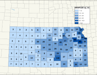
There are over 1,600 buildings, sites, districts, and objects in Kansas listed on the National Register of Historic Places in Kansas. NRHP listings appear in 101 of the state's 105 counties.

This is intended to be a complete list of the properties and districts on the National Register of Historic Places in Fairfield County, Connecticut, United States. The locations of National Register properties and districts for which the latitude and longitude coordinates are included below may be seen in an online map.

This is a list of the National Register of Historic Places listings in Litchfield County, Connecticut.

This is a list of the National Register of Historic Places listings in New Haven County, Connecticut. It is intended to be a complete list of the properties and districts on the National Register of Historic Places in New Haven County, Connecticut, United States. The locations of National Register properties and districts for which the latitude and longitude coordinates are included below, may be seen in an online map.

This is a list of the National Register of Historic Places listings in Lancaster County, Pennsylvania.

Millington is a village within the town of East Haddam, Connecticut, United States. Millington lies halfway between East Haddam center and Salem center. It is the section of East Haddam that is the closest to Devil's Hopyard State Park. The village is connected to East Haddam Center and to Devil's Hopyard State Park by a series of secondary roads that are maintained by the state. The road is given an unsigned designation "Special Service Road 434", which runs on Mount Parnassus Road, Millington Road, Haywardville Road, and Hopyard Road.

Devil's Hopyard State Park is a public recreation area located at the Eightmile River's Chapman Falls in the town of East Haddam, Connecticut. The 1,000-acre (400 ha) state park includes facilities for hiking, fishing, bicycling, picnicking, and camping. It is managed by the Connecticut Department of Energy and Environmental Protection.

The Middlefield–Becket Stone Arch Railroad Bridge District is a historic district extending through parts of the towns of Chester, Middlefield, and Becket, Massachusetts. The district encompasses a 3.7-mile (6.0 km) stretch of railroad right of way in which there are ten bridge crossings, including nine over the west branch of the Westfield River. The bridges were built in four time periods: 1840, 1866, 1912, and 1928. Nine of the ten bridges are stone or concrete masonry work, and one is a truss girder bridge. All are, with only minor exceptions, in excellent and original condition. The bridges were built to carry the Western Railroad through on its run from the Connecticut River to the Hudson River. This section of railroad was the most expensive the company had to build, costing over $1 million in 1840.
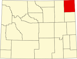
This is a list of the National Register of Historic Places listings in Crook County, Wyoming.

This is a list of the National Register of Historic Places listings in Uinta County, Wyoming.

There are eight properties listed on the National Register of Historic Places (NRHP) in Linn County, Kansas. Two of the sites are the location of historic events. The Marais des Cygnes Massacre Site is the location of the Marais des Cygnes massacre, an 1858 event during Bleeding Kansas in which pro-slavery advocates kidnapped 11 anti-slavery settlers, killing five of them. John Brown temporarily used the site as a fort, and the property was listed on the NRHP in 1971. The Battle of Mine Creek Site preserves the location of the Battle of Mine Creek, which was fought in 1864 as part of Price's Raid during the American Civil War. Confederate general Sterling Price's army was retreating after being defeated at the Battle of Westport and was attacked by pursuing Union troops. Price's Confederate lost heavily in men and supplies. The site was added to the NRHP in 1973.

This is a list of the National Register of Historic Places listings in Chippewa County, Wisconsin. It is intended to provide a comprehensive listing of entries in the National Register of Historic Places that are located in Chippewa County, Wisconsin. The locations of National Register properties for which the latitude and longitude coordinates are included below may be seen in a map.
This is a list of the properties and historic districts in Stamford, Connecticut that are listed on the National Register of Historic Places. The locations of National Register properties and districts for which the latitude and longitude coordinates are included below, may be seen in an online map.
This is a list of the National Register of Historic Places listings in Greenwich, Connecticut.

The East Putney Brook Stone Arch Bridge is a historic stone arch bridge in eastern Putney, Vermont. Built in 1902, it is a rare statewide example of a 20th-century stone bridge, and one of a number of such area bridges built by Townshend farmer and mason James Otis Follett. It was listed on the U.S. National Register of Historic Places in 1976. The bridge is located just west (upstream) of the present alignment of River Road, which it formerly carried.

The Follett Stone Arch Bridge Historic District encompasses a group of four stone arch bridges in southwestern Townshend, Vermont. All four bridges were built by James Otis Follett, a local self-taught mason, between 1894 and 1910, and represent the single greatest concentration of surviving bridges he built. The district was listed on the National Register of Historic Places in 1976.

The West Townshend Stone Arch Bridge carries Round Hill Road across Tannery Brook in the village of West Townshend, Vermont. Built about 1910, it is one of the few surviving bridges of a group built by local mason James Otis Follett in the early 20th century. It was listed on the National Register of Historic Places in 1977.

The Mill Brook Bridge is a historic stone arch bridge, located just north of Lower Blissville Road in Lisbon, Connecticut. With a plausibly estimated construction date of the 1790s, it is probably the oldest surviving stone arch bridge in the state. It was listed on the National Register of Historic Places in 1997. Since then, it has deteriorated and is partially collapsed.


